NOTE
This page is an abbreviated version of this writeup, and is narrowly focused on the choice of layout for the main intersection and why the “Alternative C” design merits another look. The full version is both broader in scope and contains much more detail, including plots of the most recent traffic speed/volume data, ways to make MassDOT’s 2 designs a little better if they really won’t consider other alternatives, and arguments for narrowing Mem Drive on either side of the main intersection.
Background
On August 6th, MassDOT held the first public meeting for the Reid Overpass project since January to reveal their final 2 design options, from which they will select a single “preferred concept” (based on public comments and additional traffic simulations) to take into the formal design process. Here they are for reference:
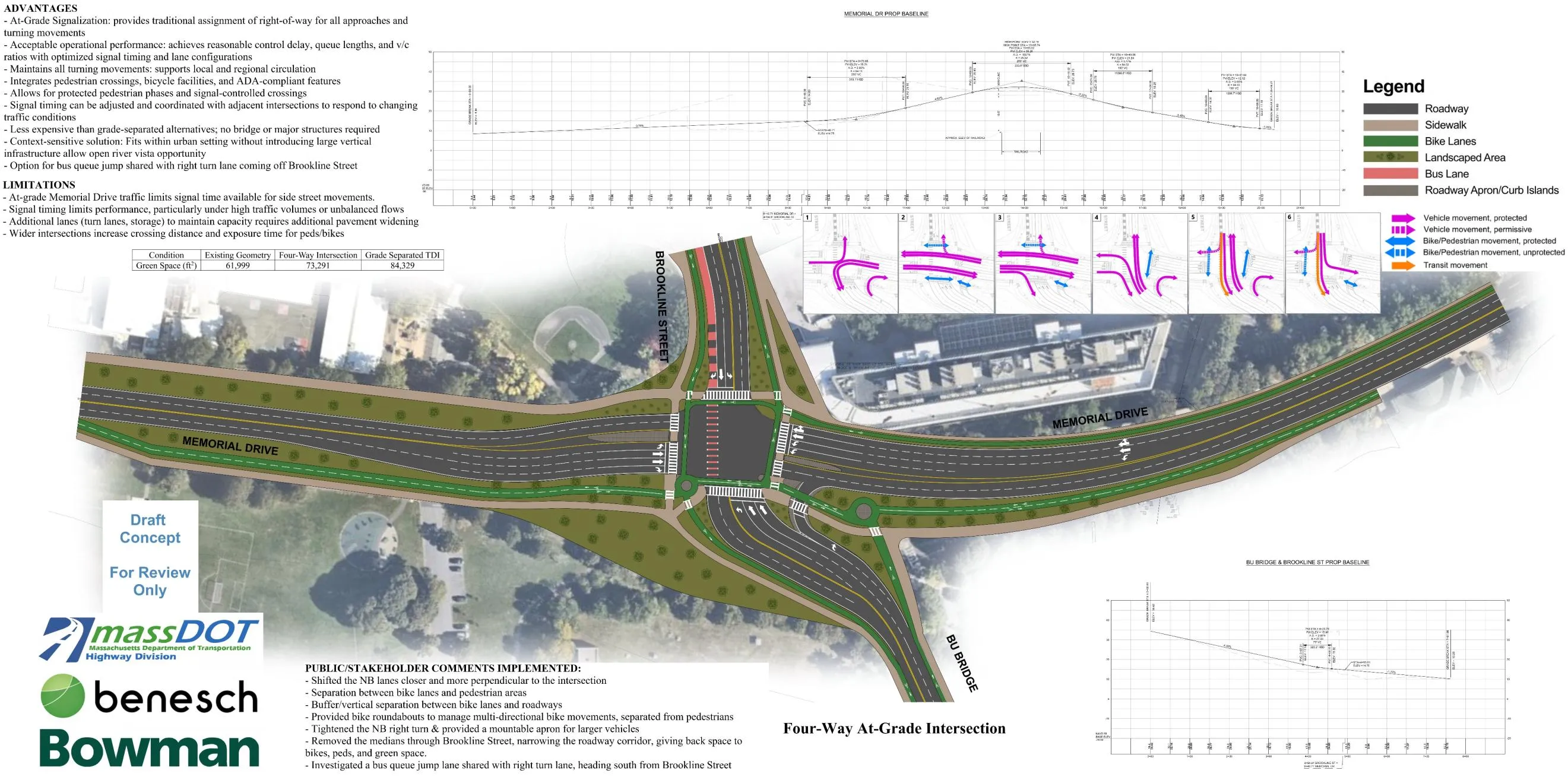
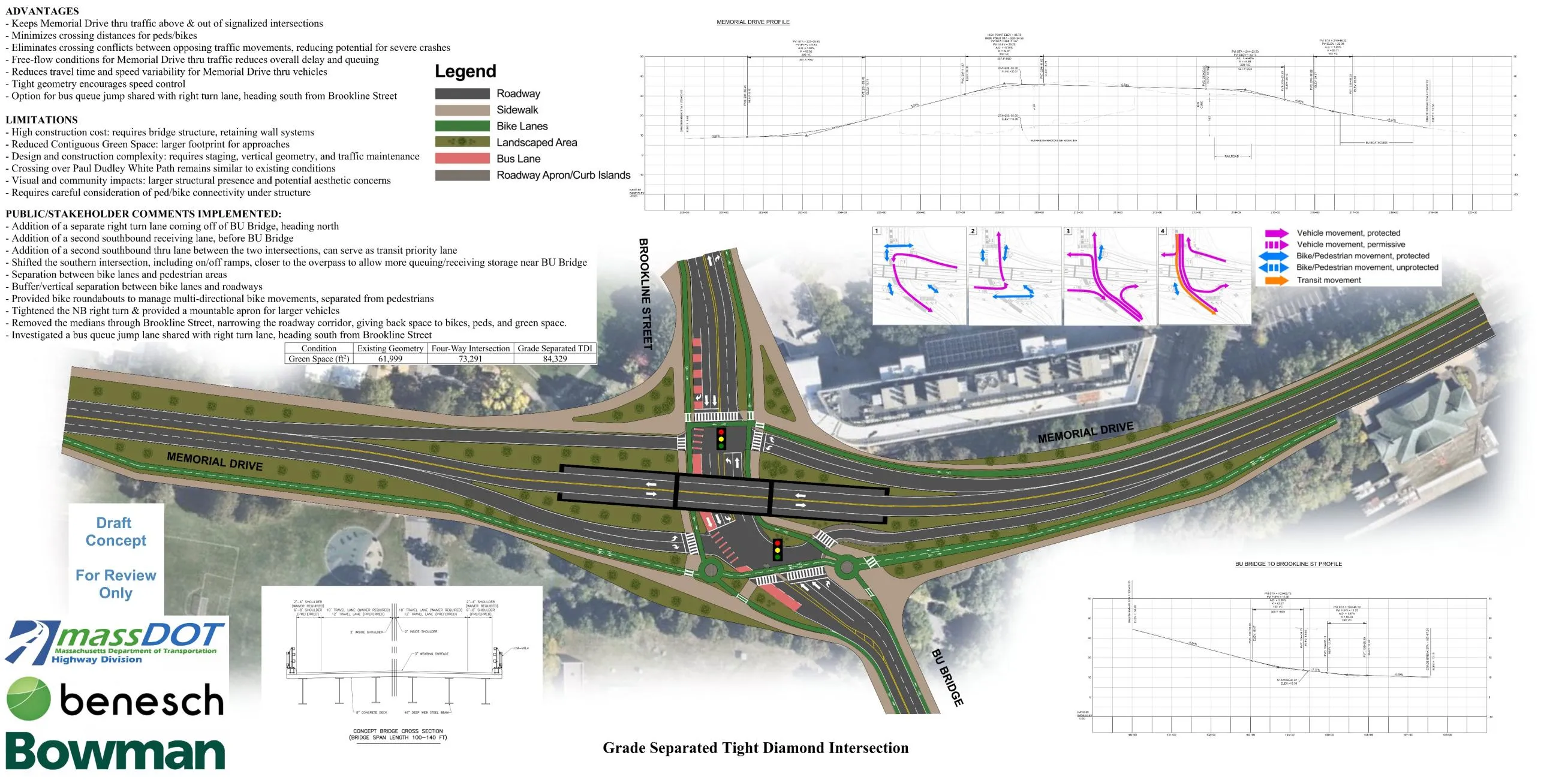
While minor design improvements have been made, MassDOT has not really budged at all on the most important advocate asks:
- Overall roadway footprints and crossing distances are pretty much the same as what was presented in January - in fact, the four-way design has actually lengthened the river path crossing from 4 to 6 lanes!
- And both options increase crossing distances compared to existing conditions today.
In other words, these designs still fall short of the mark in terms of addressing safety issues, improving the pedestrian/bicycle experience, and restoring the area to be a riverfront rather than a highway.
Of particular concern is that both of MassDOT’s options are similar in design to other known high-crash intersections nearby along the same corridor. For example:
- The four-way option is similar to the Land Blvd/Gilmore Bridge/Rt 28 at the end of the Memorial Drive corridor, both in terms of size and being adjacent to a traffic bottleneck. That intersection is the site of constant red-light running and blocking the box/crossings, is ranked in the top 200 crash clusters in the entire state, and is also a top 5% bicycle crash cluster and a top 5% pedestrian crash cluster in the Boston MPO.
- The TDI option is the same layout as Mass Ave/Mem Drive, a top 200 crash cluster in the entire state as well as a top 5% bicycle crash cluster in greater Boston, which was recently the site of a fatal cyclist crash where an MIT professor riding his bike was struck by a truck. And 3 consecutive TDIs on the parkway across the river, Soldier’s Field Road, are also TDIs that all currently are or have recently been in the top 5% high-crash intersections in the Boston MPO.
This only further emphasizes that neither of MassDOT’s options are suitable - which is why I’d like to push for Alternative C one more time. AltC remains significantly better than MassDOT’s options in terms of safety, ped/bike-friendliness, and minimizing roadway footprint by the riverfront. And analysis using the most recent traffic April 2026 traffic data shows that it might actually have the best traffic performance as well! In light of this, I believe that AltC is a win-win solution that merits further analysis by MassDOT.
What is Alternative C?
To briefly summarize for those who haven’t seen the previous March writeup: Alternative C/AltC is an advocate proposal that was created in reaction to MassDOT’s oversized, highway-like January design options. There have been some minor edits since then, including some simplification in response to MassDOT’s comments, and below is the latest sketch of what it looks like.
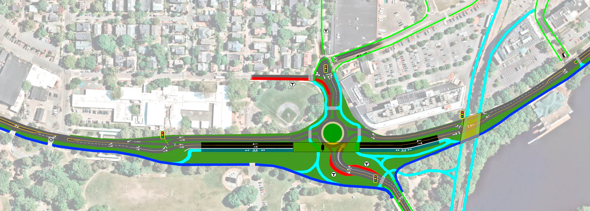
At its core, it consists of a compact single-lane roundabout (90-120 ft diameter), together with an overpass carrying 2 lanes of Memorial Drive thru traffic plus a 3rd lane exclusively for pedestrians, cyclists, and other users of the Charles River paths. Simple 2-phase crossover intersections to the east and west allow the roundabout and overpass to be combined in a way that minimizes the overall footprint and keeps the roundabout compact (and therefore slow and safe).
There are additional features/changes (some seen in the sketch) that would be great but are ultimately optional, so will not be discussed here - see the more detailed proposal in the full writeup instead.
AltC (still) outperforms other options
Comparing footprint
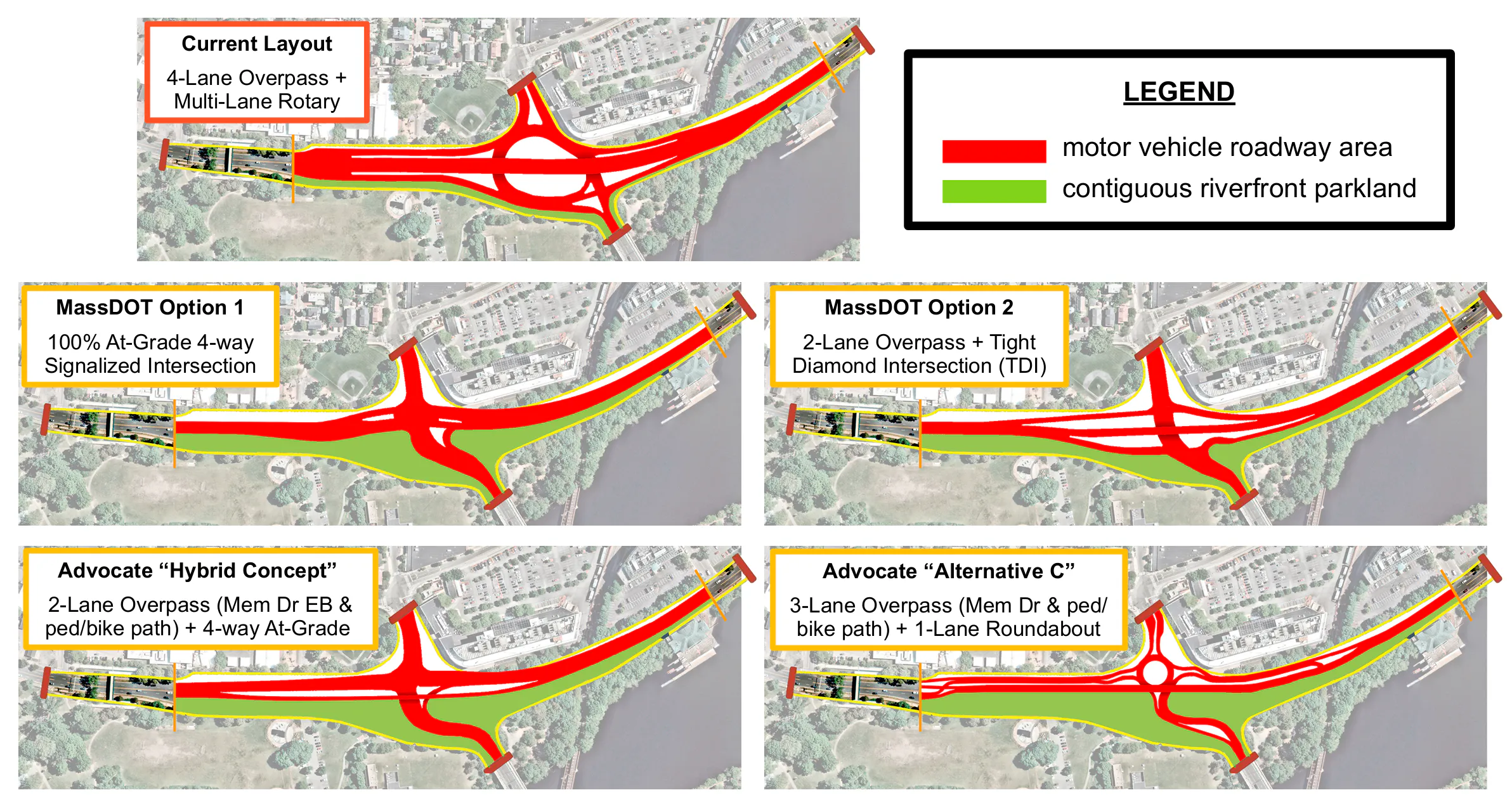
Even after MassDOT’s design revisions, AltC still does better all around. Below is a visual comparison of the footprint of different designs, both looking at the roadway area in red, as well as how much riverfront parkland is reclaimed. For completeness, this comparison also includes another advocate proposal, the “Hybrid Concept” put forward by Ari Ofsevit last month.
Comparing key quantitative metrics
In addition, below is a table showing how the various designs compare in terms of several key metrics:
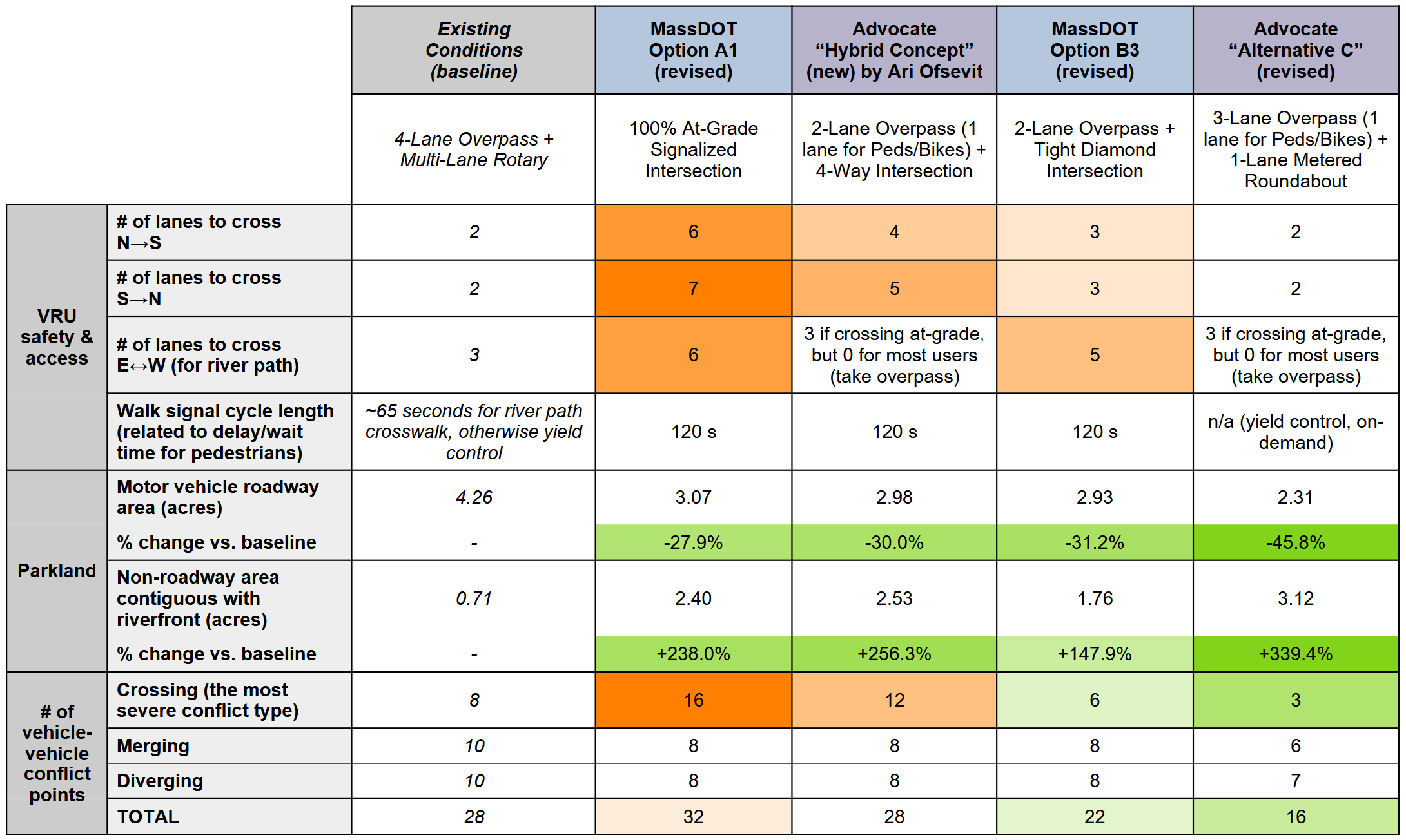
Concerningly, MassDOT’s 4-way option has double the number of crossing conflicts compared to today. This is the most serious kind, associated with angle/T-bone crashes. Meanwhile, a single-lane roundabout has zero crossing conflicts, so as a result AltC has the fewest of these even after including the crossover intersections. This is one of the reasons why roundabouts are provably much safer than signalized intersections, with MassDOT’s own roundabouts page stating that converting the latter to the former can reduce fatal and injury crashes by 78%.
Both of MassDOT’s options have significantly increased ped/bike crossing distances and wait time. Even though they would be single-stage crossings, 5-7 lanes is still very large. Some examples to help visualize what that might look/feel like:
- standing at the intersection corner by the Morse School field and looking across 6 lanes of Memorial Drive towards Magazine Beach/the river might look something like this street view from Charles St, looking across 6 lanes of Storrow Drive towards Lederman Park/the river
- below is a street view showing a 6-lane crossing from a different state road, with some pedestrians in it for scale
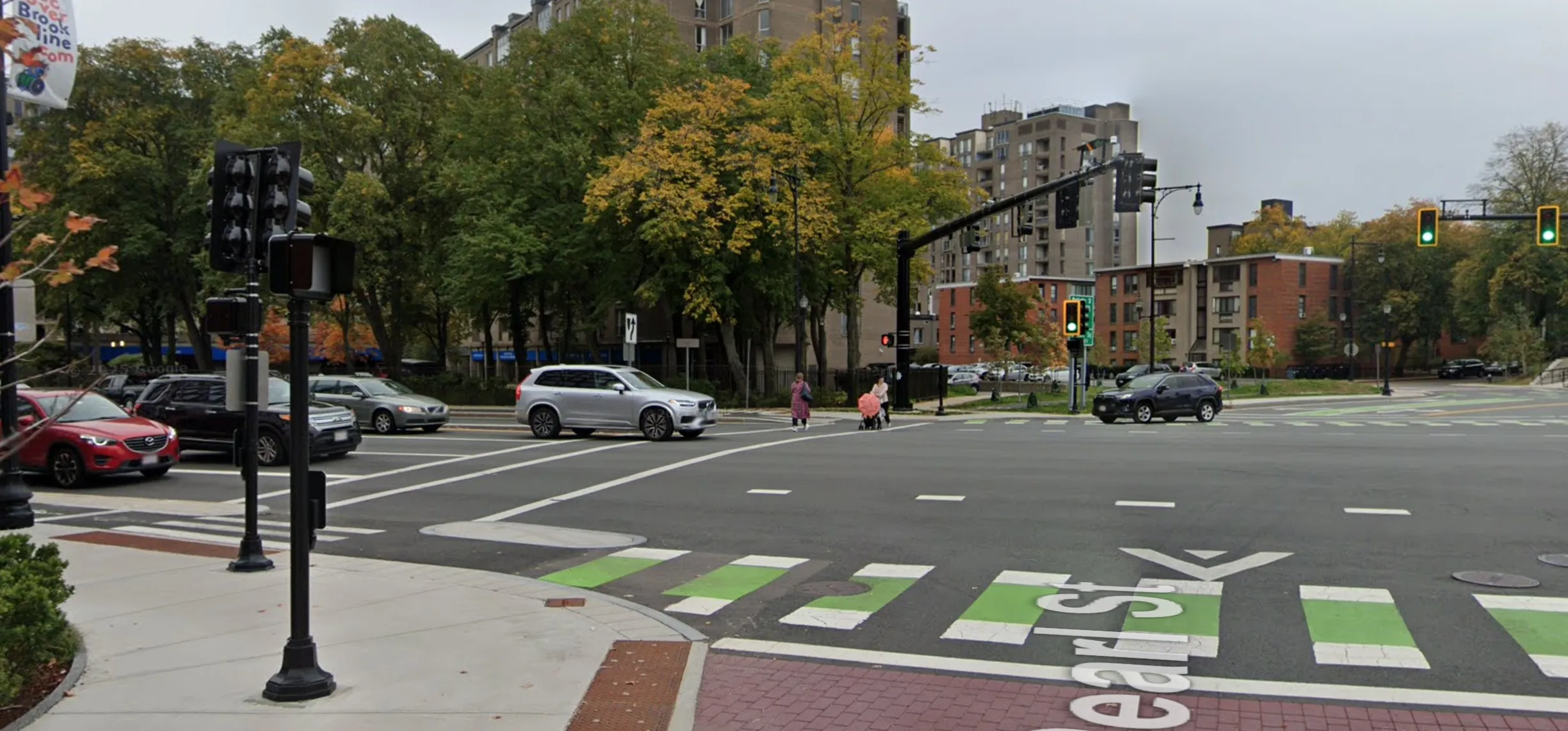
Something like this is NOT appropriate for the riverfront parkland context of the Reid Overpass project area.
Better traffic performance as well
Finally, even by the metric that MassDOT gives the highest priority, which is minimizing delay for drivers, AltC seems better: the roundabout has a LOS of C, while MassDOT’s designs have a LOS of E. Below is the output of a roundabout analysis tool using the latest April 2026 traffic count data.
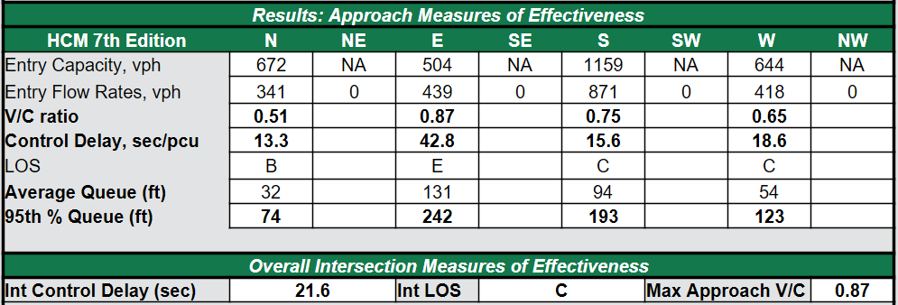
This may seem surprising given the heavy traffic at this intersection today, but the presence of a bypass lane for BU Bridge to Mem Drive EB right turns makes a big difference, and the fact that the heaviest exit (to BU Bridge SB) is right before the heaviest entry (from BU Bridge NB) also helps:
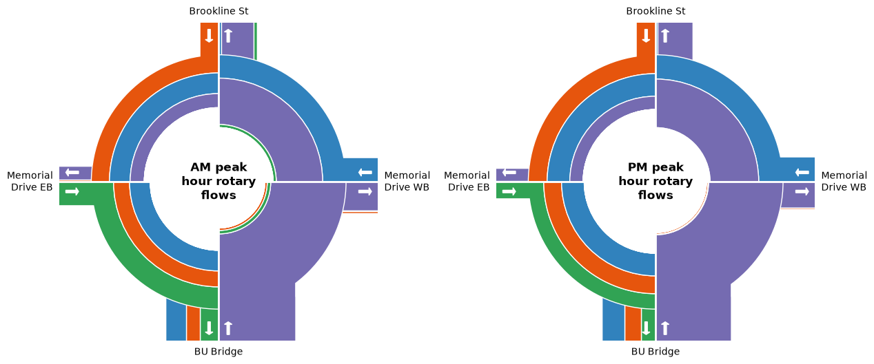
One thing that’s important to acknowledge, given that people will understandably draw comparisons between the rotary that exists today and the proposed AltC roundabout, is that a standalone roundabout does have the potential to seize up if one of the exits backs up (similar to what happens today when the BU Bridge lane heading into Boston backs up). However, AltC has traffic signals on all 4 approaches that would safeguard against this risk through metering, where the amount of traffic flow allowed to enter the roundabout is dialed back until the backup on the exit leg subsides. So while lines may still form at times, they will be organized and orderly on Mem Drive rather than in the middle of the intersection blocking other traffic movements - something MassDOT’s designs are not immune to, given the box-blocking behavior regularly observed at the Land Blvd/Gilmore Bridge/Route 28 intersection at the end of this same corridor (see this recent video showing rush-hour conditions there).
The other main traffic components of AltC besides the roundabout are the 2 crossovers. These are very simple two-phase intersections. Looking at the worst-case scenario, the eastern crossover in the AM peak:
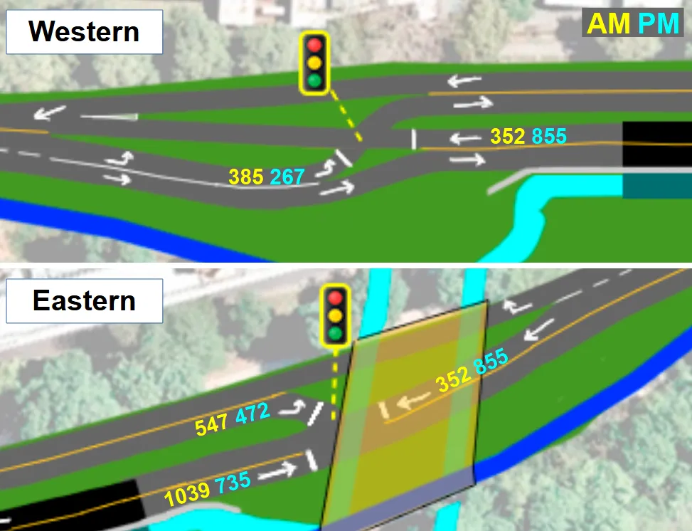
If 2/3 of the crossover signal’s green time is given to overpass thru traffic & 1/3 to the roundabout outflow left turn, and assuming an ideal saturation flow rate value of ~1900 cars/hour/lane (as per this FHWA page), that yields a capacity of 1266 & 633 vph, respectively. Which is higher than the measured peak volumes shown above; to be exact, the counts are 86% and 82% of these rough capacity numbers. So the crossovers seem feasible as well! In the worst case scenario, a queue might form on Mem Drive EB for a few minutes, but that’s hardly the end of the world.
Of course, these are back-of-the-envelope calculations and there are many other considerations (dead time/startup loss switching signal phases, roundabout-crossover interactions that can only be evaluated through simulations, etc.) that would need to be accounted for in a full traffic evaluation. But the point is that AltC is feasible enough to merit such an analysis, rather than being dismissed for tangential reasons.
A backwards order of operations
MassDOT’s large and overly highway-like designs, which might even be a downgrade from existing conditions in some respects, are the unsurprising outcome of MassDOT continuing to use peak 15-minute volumes for their traffic analysis, despite repeated requests from advocates to use peak hour volumes instead. This is a reflection of their prioritization of motor vehicle traffic above all else.
It is unacceptable to base the roadway design upon data representing literally the worst 1% of the day, especially for a project that is supposed to be multi-modal. If accommodating peak 15-minute flows is treated as a core requirement of the design, it becomes impossible to achieve any semblance of balance when it comes to addressing the many other needs for the project area. That additional roadway capacity comes at the expense of safety, the riverfront, and accommodations for people outside of cars. Using a single peak data point also ignores the normal day-to-day variation in traffic patterns, as well as the fact that traffic is malleable: drivers can and will seek alternate routes if needed, or start their trips slightly earlier or later.
But MassDOT’s approach tries to decouple the roadway design from safety issues. The focus is on accommodating spikes in traffic, while safety is treated as something that can be addressed later with some add-on features once a base design is selected. However, this decoupling is not actually possible: the excess capacity used to deal with those spikes means an overly wide and heavily underutilized roadway that will only worsen the rampant, dangerous speeding observed today.
The data show that the current wide roadway design, which the latest designs do not change (or in the case of the 4-way, even widens), essentially encourages more than half of Memorial Drive drivers to go faster than 35 mph, and many significantly faster (including a few hundred vehicles daily going over 50 mph). According to the IIHS, at 35 mph there’s a 52% chance of serious injury or death for a pedestrian struck by a car, or 91% if struck by a pickup.
| Vehicle speed | Median-height car | Median-height pickup |
|---|---|---|
| 20 mph | 16% | 27% |
| 25 mph | 25% | 52% |
| 30 mph | 37% | 75% |
| 35 mph | 52% | 91% |
| 40 mph | 66% | 97% |
| 45 mph | 78% | 99% |
| 50 mph | 86% | 100% |
| 55 mph | 92% | 100% |
| 60 mph | 95% | 100% |
No amount of safety band-aids can fix this problem, because it is inherent to MassDOT’s current design approach. Rather paradoxically, MassDOT’s designs will only be safe during the brief periods of the day that there’s traffic congestion. The lack of any crash analysis further highlights how safety is taking a back seat throughout this process.
Alternative C takes the opposite approach: it starts with a design that is safe 24/7, independent of traffic levels, and then has additional features that can kick in to manage traffic spikes as needed. This is the order of operations that should be followed when redesigning a high-crash location like this one!