Overview
NOTE
A set of slides summarizing the key points of the alternative proposal can be found here. However, the longer writeup below contains important background/context for the proposal, particularly discussion of the issues with the current intersection as well as the designs MassDOT presented in January.
The Reid Overpass, which carries Memorial Drive over the unsafe and often-gridlocked rotary at the Cambridge end of the BU Bridge, is nearing the end of its service life and needs to be addressed. MassDOT is currently in the design process for a project that not only touches upon the overpass, but could potentially reconfigure the broader intersection as well.
Goals
This project presents a once-in-a-lifetime opportunity to overhaul a critical, currently dysfunctional node of the local transportation network. Any redesign must achieve the following:
- Address long-identified safety issues with this high-crash intersection, particularly for vulnerable road users (VRUs) such as pedestrians, cyclists, and people using mobility aids:
- Prevent speeding and improve sightlines
- Ensure organized and clear movements for all users
- Minimize vehicle-VRU conflicts/exposure by reducing crossing distances
- Prevent intersection traffic from backing up into the adjacent neighborhood and causing gridlock that impacts Cambridgeport residents, the Morse School community, and others.
- Incorporate bus priority elements so key MBTA buses, particularly the 47 bus (soon to become a high-frequency bus route), no longer get stuck in traffic here.
- Reclaim as much green space as possible — particularly riverfront parkland.
- Raise and widen the bridge over the Grand Junction railroad to accommodate critical future transit service and new connections for the regional off-street path network.
Review of MassDOT’s initial proposals
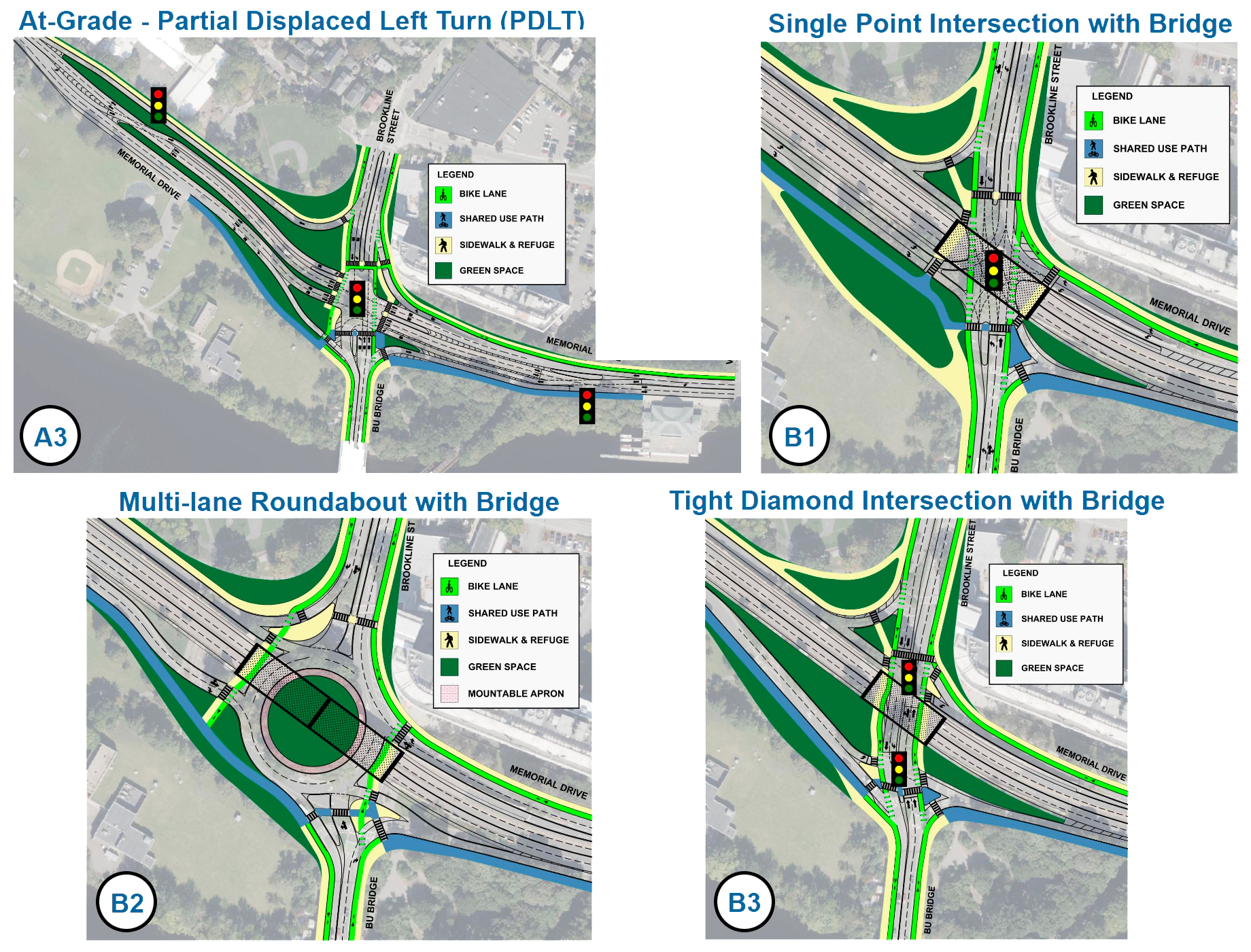
At the first public hearing for this project on January 6, 2026, the MassDOT project team unveiled the following 4 “conceptual alternatives” to be advanced for further analysis and development:
Unfortunately, these proposals fall far short of the above goals. Every single option trades pedestrian/cyclist safety and accessibility for more vehicle lanes, in an attempt to relieve congestion — but these roadway expansions won’t even improve the situation for drivers, because the real traffic bottleneck lies elsewhere. If anything, the large intersection designs risk replicating the congestion and box-blocking issues of the Land Boulevard/Charlestown Ave/Route 28 intersection at the end of this corridor.
Nor do any of the proposals address, let alone acknowledge, the severe bus delays through this intersection. And the only nod to Cambridgeport gridlock appears to be a new slip lane by the Morse School field, present in all 4 designs, which will provide very little relief for drivers while worsening safety for everyone else.
The full post contains a more detailed look at the various issues with MassDOT’s proposals, but here is a brief overview of each alternative:
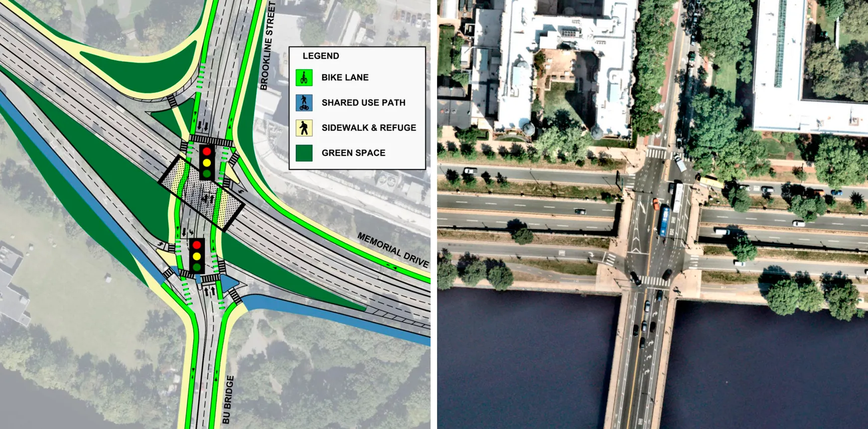
- A3 turns the existing 2-stage/3-lane river path crossing for pedestrians and cyclists into a 3-stage/6-lane crossing, and the shallow crossovers for the displaced left turns create a significant risk for wrong-way driving and head-on crashes.
- B1 is a single-point interchange (SPUI), which is explicitly contraindicated when there are high pedestrian/cyclist volumes parallel to the overpass and when the intersection has a skew angle > 30 degrees, both of which are true here.
- B2 recreates the existing 2-lane rotary, so it will have the same traffic issues as today, with even worse VRU safety by removing the signal-protected crossing for the river path. Instead, path users will have to wait for drivers in the 3 BU Bridge lanes to voluntarily yield. In addition, expanding multiple entry and exit ramps to 2 lanes will create new double-threat crash risks.
- B3 takes the design of the Memorial Drive/Mass Ave intersection a bit further east on this same corridor, which is the 37th-ranked high-crash intersection in the entire state, then makes it even bigger, more complicated, and with worse sightlines.
A compact “Alternative C” to consider
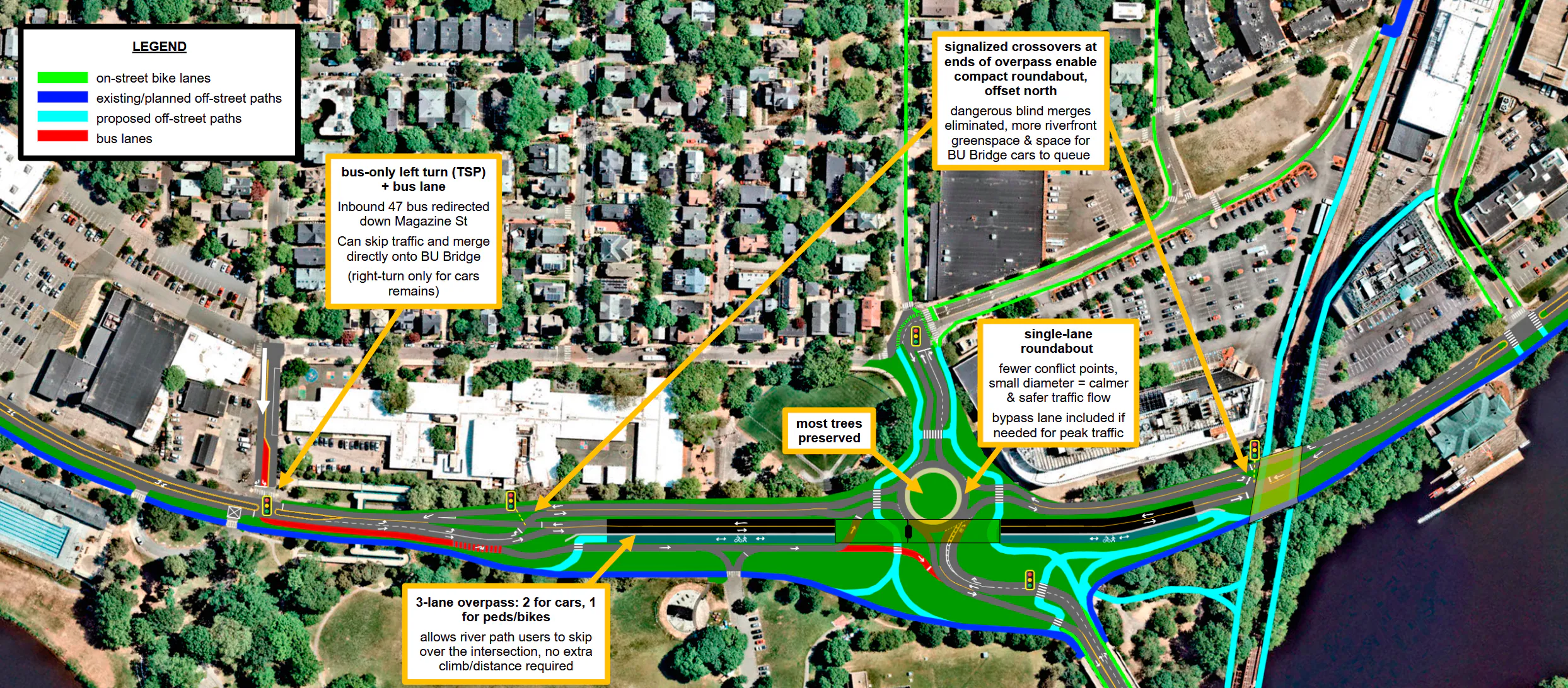
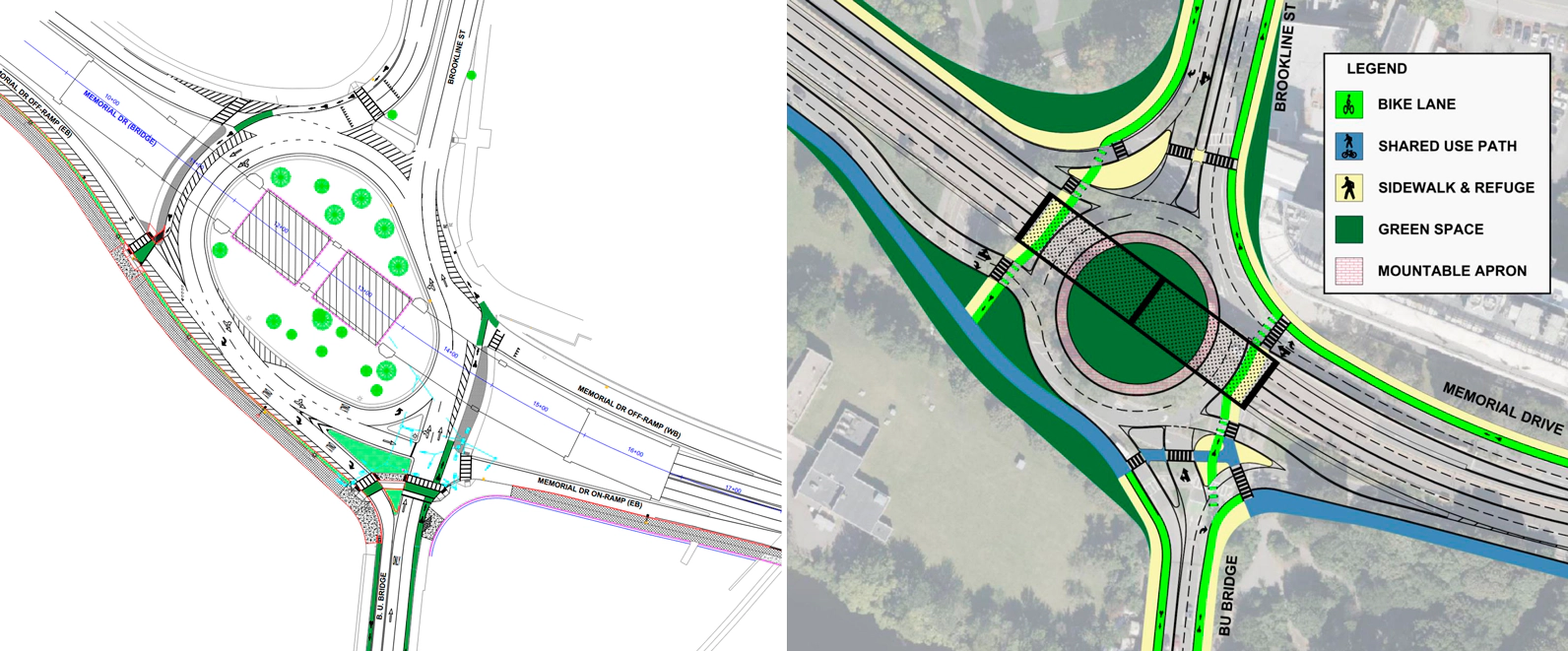
Here’s a different approach that would achieve the above goals, in a much smaller footprint: a single-lane1 roundabout, combined with a narrowed overpass carrying 2 lanes for motor vehicles + 1 lane for pedestrians/cyclists.
Prioritizing safety
The most important consideration for this design was safety for all road users: pedestrians, cyclists, drivers, and others. And the safest form this intersection could take while achieving all other goals is a single-lane roundabout.
Going from the oversized, high-speed multi-lane rotary that exists today to a compact single-lane roundabout eliminates dangerous crossing-type conflict points that are associated with more serious crashes, and significantly reduces conflicts overall. The 1-lane width and tightly-controlled curvature naturally keeps speeds low, which reduces crash rates and crash severity, as well as increases the rates of yielding to pedestrians. Traffic flows are well-defined and predictable; all users only need to worry about 1 potential conflicting movement at a time.
The safety advantage over conventional signalized intersections is even more significant: according to MassDOT’s own materials, “converting an intersection with traffic signals to a roundabout can reduce property-damage-only crashes by 48% and fatal and injury crashes by 78%.”
Making a single-lane roundabout feasible
By diverting Memorial Drive thru-traffic onto an overpass, and adding a bypass lane adjacent to the roundabout for one of the heaviest traffic flows (right turns from the BU Bridge onto Mem Drive eastbound), the amount of traffic that will actually be in circulation falls within the feasible operating range for a single-lane roundabout.
The slow and steady flow of traffic in a roundabout moves cars more efficiently than the stop-and-go of a signalized intersection, without needing excess roadway space for cars to line up and wait during the red light phase. The reduction to a single lane will prevent drivers from cutting in line and stopping the circulation, as happens in the existing rotary.
Finally, the roundabout is shifted north of the overpass using crossover signals to the east and west, which are a smaller and safer version of the crossovers in MassDOT’s option A3. This allows the roundabout to remain compact and frees up a significant amount of green space adjacent to the riverfront. The crossover signals could also be used to meter roundabout entry flows as needed, ensuring it keeps flowing during peak traffic times.
Other key changes and features
- The number of motor vehicle lanes on the overpass is reduced from 4 to 2, and 1 lane is added for pedestrians/cyclists, allowing river path users to skip over the entire intersection just like Mem Drive car traffic already can today.
- This plan proposes reversing the direction of Granite St (at least the section west of Pearl St). While this would of course require broader neighborhood discussion first, the idea is it would address the issue of Cambridgeport residents and Morse school buses and families getting caught up in rotary-bound cut-through traffic.
- This reversal also enables faster and more reliable bus service: if the main intersection is backed up, a bus-only left turn from Magazine St (using bus-actuated transit signal priority that minimizes waits) into a dedicated bus lane provides an alternative route for the inbound 47 bus to skip the traffic and merge directly onto the BU Bridge.
Additional benefits
- This plan avoids the need for costly eminent domain and/or encroaching further onto the riverfront — unlike several of MassDOT’s designs which are too big to fit in the existing roadway envelope.
- With fewer lanes, construction staging becomes less complex and the required width and maximum load rating for the bridges are also lower, further reducing costs.
- It eliminates opportunities for misbehavior like box-blocking and off-peak speeding to occur.
…and so on.
While this alternative design certainly has its own tradeoffs, it’s an example of how bigger intersections aren’t the only path forward, and how the opposite approach can actually avoid a lot of problems. And though it’s still a rough concept that will of course require further traffic analysis and conversations with stakeholders, it’s being shared in the hopes of opening up the conversation and encouraging new design approaches that step outside the highway engineering box.
A side-by-side comparison of designs
The following table2 compares MassDOT’s design options and this “Alternative C” proposal against the baseline of the existing conditions.
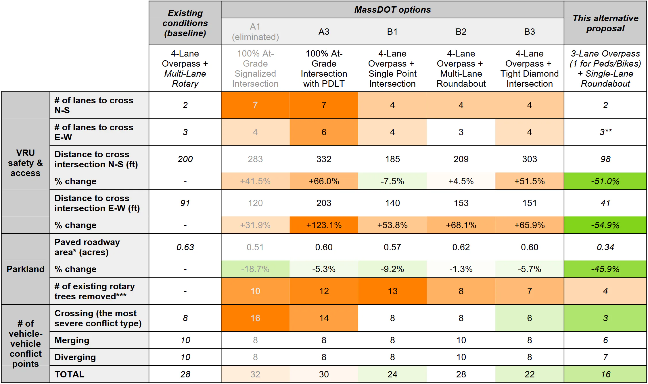
These quantitative measures confirm the visual impression of MassDOT’s designs: added lanes and increased crossing distances throughout will make this intersection less accessible than it already is for vulnerable road users, and rather than improving their safety, will instead increase their exposure to conflicts with cars.
The only reason paved roadway area doesn’t also register as an increase is because the existing rotary is so large it could fit 3 lanes. The proposed intersections are still oversized and what little roadway area they “reclaim” is distributed across many traffic islands that are unusable as parkland. This is also reflected in the number of tree removals each option would require.
On the other hand, the alternative proposal does NOT increase the number of lanes to cross, halves the current crossing distances, reduces roadway area by ~45%, and retains most of the existing trees. It also has the fewest conflict points out of all the options, both total and crossing, in a significant reduction from the existing conditions.
Next steps
Of course, the above metrics don’t capture the whole picture; they are limited to what is measurable from the information provided in MassDOT’s presentation. However, MassDOT would ideally use this kind of quantitative framework where possible when evaluating their designs and presenting them to the public. It was concerning that the project team’s evaluation of their own proposals made almost no mention of several safety issues baked into every design. More generally, the evaluation did not seem rigorous, with comparisons made against some unspecified baseline rather than existing conditions, and certain pros/cons applied inconsistently to designs. Putting some actual numbers to things will hopefully lead to a more objective and transparent design process.
MassDOT should also consider taking a step back to generate additional design concepts besides the 4 that were presented, taking a truly “multimodal” approach this time. The project team should ensure that access and safety for pedestrians, bicyclists, other path users, and transit riders are integrated from the beginning of the design process, rather than treating them as punch-list items to be dealt with at the end of a design process that is focused on “solving” driver delay first.
Overview/summary version ends here
Below is the full version of this post, which probably has more detail than most people need. Feel free to use the table of contents to jump to specific sections of interest.
To skip straight to the section about the alternative proposal, including more detailed background/rationale and a high-level traffic analysis, please click here.
Project background
The intersection currently consists of a large rotary with a 4-lane overpass carrying Memorial Drive thru traffic over it. This project was actually spurred by the need to take down that overpass, which is reaching the end of its service life3. But this is a once-in-a-lifetime opportunity to address the broader intersection — something that the community and various advocacy groups have been requesting for years, if not decades.
It’s not just Memorial Drive traffic that’s impacted by the design of this intersection: the Dr. Paul Dudley White (PDW) path, a heavily-used/popular multiuse path that loops around the Charles River Reservation and a key piece of the regional network of off-street paths, also passes through here. People traveling along the path need to cross traffic coming on/off the BU Bridge, and this is also a significant interchange for pedestrians and cyclists going between Cambridge and Boston.
Pretty much everyone agrees the current layout isn’t working for anybody, regardless of whether you’re on foot, in a car, riding the bus, or on a bike. And it isn’t just unpleasant and frustrating, but outright dangerous - this is a high-crash location, and in particular has been flagged by the state as a top 5% HSIP bicycle crash cluster for at least a decade4.
There’s been some previous discussion of reconfiguring this intersection, most notably back in 2019 as part of the planning for Phase III of DCR’s Memorial Drive Greenway Improvements, before that project was scaled back to only modify the section west of Harvard Square. This post will reference some of the traffic data that was presented then, as MassDOT has not yet shared the results of its more recent data collection. MassDOT has also done some preliminary public engagement as well, including attending a Fall 2024 community meeting hosted by the Cambridgeport Neighborhood Association (CNA).
However, MassDOT’s actual first official public meeting on this project was held earlier this year on January 6th, 2026 (here are links to the video recording, the presentation slides, and the meeting transcript). Things initially seemed promising: in the first part of the presentation, MassDOT correctly identified the various problems with the intersection that they’d gathered from community input, and stated their commitment to improving safety and supporting multimodal transportation.
Unfortunately, the presentation took a sharp turn with the reveal of the proposals: every single one of the concepts that MassDOT has selected for advancement is a roadway expansion, adding more lanes than currently exist today. Some of them *might* improve traffic flow under the assumption of idealized driver behavior — but realistically, these will turn into a nightmare of blocking the box, recreating a mess similar to the intersections of Western Ave/Memorial Drive or Land Blvd/Gilmore Bridge/Rt 28.
Even more critically, these are a significant downgrade in safety and connectivity for VRUs traveling between Cambridge and its riverfront, as well as along the river itself. The fact that thousands5 of pedestrians and cyclists pass through here daily, despite the cramped and heavily deteriorated river path leading up to the bridge and the unprotected bike lanes on the bridge itself6, highlights just how crucial this connection is for everyone, not just drivers — yet MassDOT’s proposals show little consideration for anyone outside a car.
None of the designs contain any transit accommodations, either, even though key buses often spend significant amounts of time stuck in traffic here. This includes the 47 bus, which will be upgraded to a high-frequency route in the near future as part of the MBTA’s Bus Network Redesign.
In other words, all the preamble about safety and multimodal transportation was not reflected in MassDOT’s proposals at all. It is clear from the excess capacity built into every design that “traffic operations” is being weighted above all else, fundamentally warping the design process to the point of actively preventing any other goals from being met.
Side note: the Grand Junction bridge replacement is also critical
Before diving deeper into all that, though, let’s look at a piece of the project that’s flown under the radar: the replacement of the bridge over the Grand Junction railroad tracks.
(if you want to skip straight to discussion of the main intersection, click here)
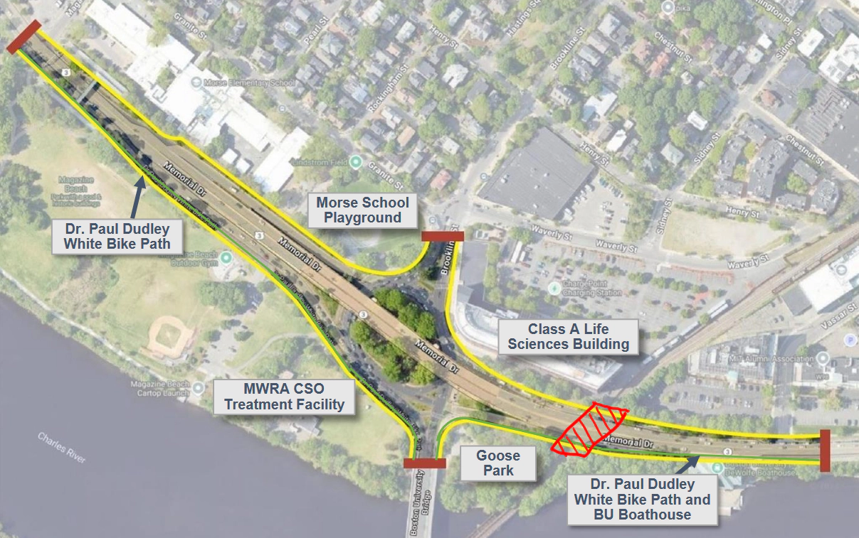
Located immediately east of the Reid Overpass, this bridge is relevant to the project because it essentially determines the highest ground elevation point, which in turn affects all the topography/roadway and sidewalk slopes for a big chunk of the project area.
This replacement will be done regardless of whether the overpass is rebuilt or not, and it is critical that this bridge is both 1) raised to accommodate future MBTA transit service on the Grand Junction railway line, and 2) widened to fit new off-street path segments on either side of the transit ROW. The current configuration of the bridge cannot support either of the above.
There absolutely is strong demand for better cross-town transit routes, if the ridership of cross-town buses is any indication — especially one serving the major employment hub of Kendall Square. But this goes beyond just filling in one gap in the network: the way that the radial “hub-and-spoke” layout of the MBTA subway system routes all trips through downtown Boston means that the downtown core is overloaded. The Green Line central tunnels are at capacity, with trolley congestion there already regularly responsible for delays in service, and downtown T stations (e.g. Park St and Downtown Crossing) are overcrowded, as are the trains by the time they get there. Circumferential transit is absolutely necessary to maintain the overall mobility of the Boston area in the future.
Regardless of whether a future transit line here is implemented as heavy rail (electrified Commuter Rail) vs. light rail (Green Line-style trolleys)7, the current 16’2” vertical clearance is far too low for either. Increasing it to the 22.5’ minimum mandated by current state law for bridges over railroad tracks (or at least whatever clearance the MBTA says would be necessary8 - if less than 22.5’, a waiver from the state DPU is needed) would future-proof this bridge for whatever gets built.
The horizontal clearance is also important: it should be widened enough to accommodate a shared-use path on either side of the Grand Junction transit ROW. This would enable future 100% off-street connections between the Grand Junction multi-use path and the Charles River paths on both sides of the river, opening up access to the full Charles River path network for young kids, seniors, inexperienced cyclists, or anyone else who doesn’t feel comfortable negotiating busy roadway crossings or unprotected on-street bike lanes.
Why have a path on both sides?
- The western side would connect paths on both river banks to each other, as well as allow Grand Junction path users to connect to them directly. Currently, the only 100% off-street, cross-river connection in the area is the Weeks Footbridge, from which getting to any actual destinations requires traversing one of the most unpleasant sections of the Charles River loop, the noisy and polluted stretch immediately adjacent to Storrow Drive and the elevated portion of I-90 (which is itself slated for a massive project to replace the aging viaduct with an at-grade option, among many other things).
- The eastern side would connect from Vassar St and provide a connection over Storrow Drive directly to the Boston University campus, specifically the BU Beach area, which in turn is a great starting point for low-stress bike travel in the direction of Back Bay by way of Bay State Rd. Not to mention, this would create a direct off-street connection between the BU and MIT campuses as well9.
If MassDOT cannot widen the bridge enough for 2 paths, a less-good but workable alternative is to have a single west-side path, but have it extend beyond the southern riverbank connection to cross Storrow Dr, then loop it through a brand-new ped/bike tunnel under the GJ tracks in order to complete the link to the BU Beach. However, this would miss out on the direct connection with the Vassar St cycle track.
It’s unfortunate that the issues around the main intersection dominated the public meeting, because this is an equally critical piece of multimodal connectivity, albeit with a much longer planning horizon. But while it’s understandable for the meeting audience to focus on the immediate impacts the Reid Overpass project would have on them, it’s troubling that the state Department of Transportation categorizes raising the bridge clearance as a project desire, a.k.a. the lowest priority/“nice to have but not required,” in contrast to their listing “equal or better intersection level of service [for motor vehicles]” as a top-level constraint that absolutely cannot be violated.
This is despite the fact that the mode shift Grand Junction transit service could unlock would do far more to reduce congestion on the BU Bridge than any roadway reconfiguration here could possibly achieve. But instead, it’s being treated as a wishlist item from the MBTA and/or the city of Cambridge. This backwards prioritization highlights the need for improved coordination between state agencies, and for more forward-thinking and holistic planning at the state level when it comes to solving our regional transportation issues.
Traffic issues with the existing intersection
Safety should really be the #1 priority here, but as traffic appears to be MassDOT’s primary concern, let’s discuss that first. MassDOT’s proposed road expansions fundamentally miss the key point when it comes to congestion here, namely:
The real bottleneck is the Comm Ave/BU Bridge signal
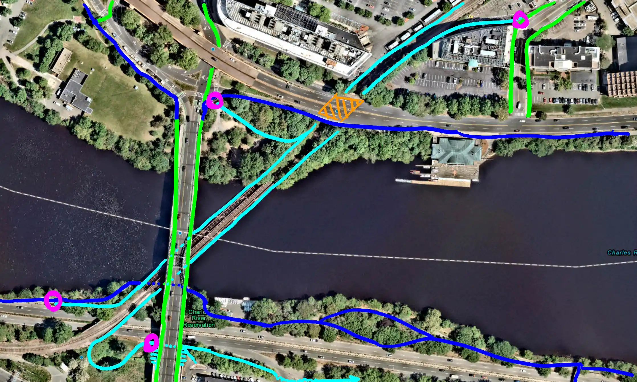
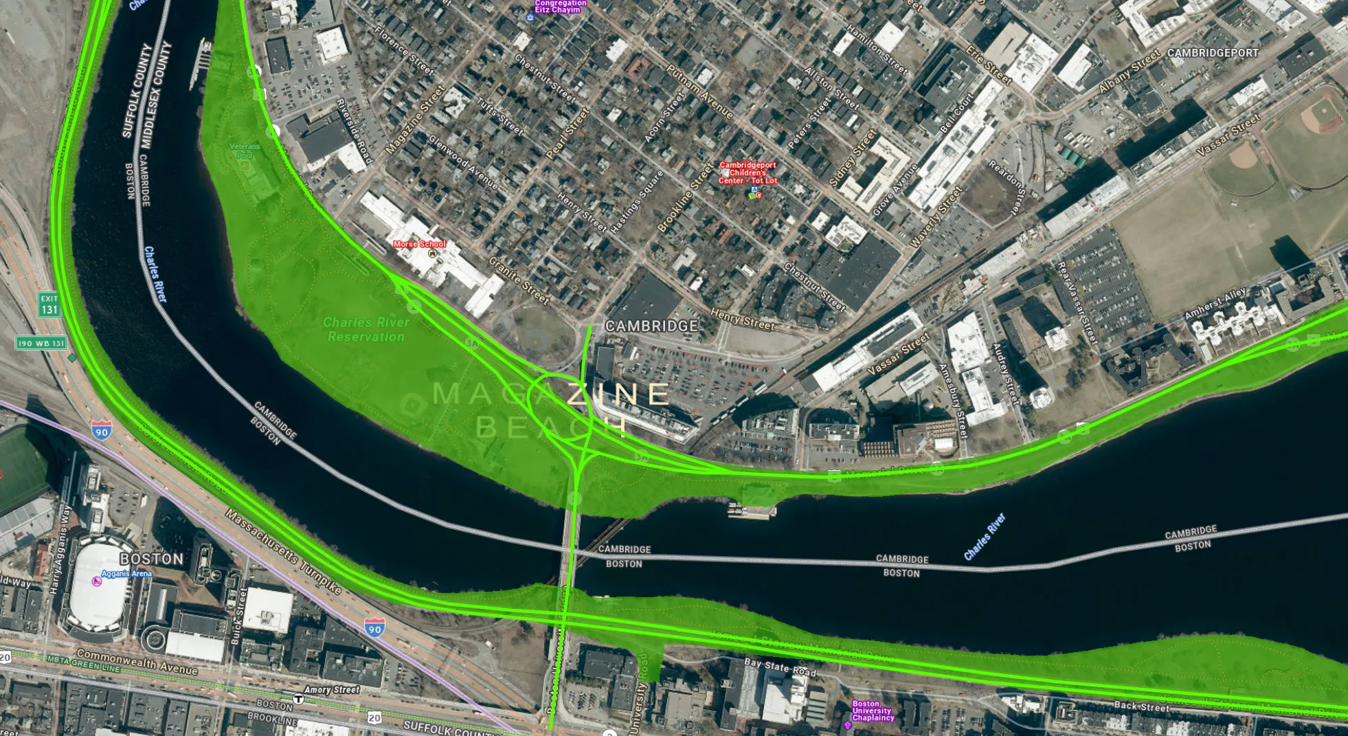
The below aerial view clearly shows the root of the problem: 3 different streams of traffic are all trying to cram into the single southbound lane of the BU Bridge.
And the capacity of that single southbound lane is limited by the signals at the Commonwealth Ave end of the bridge, which is probably around ~1,100 vehicles per hour. That capacity was slightly increased last year10 but is now maxed-out, or at least cannot be increased further without making tradeoffs impacting Comm Ave (not just motor vehicles, but Green Line trains and crossing pedestrians as well).
The roadway expansions MassDOT is proposing for the Cambridge side of the bridge will do nothing to relieve congestion, because the real bottleneck isn’t here but at the opposite end, outside the project area11. In other words, “increasing throughput” is simply not possible within the project scope, so MassDOT should not be proposing additional lanes, full stop — especially when doing so comes at the expense of safety.
This absolutely isn’t to say that there’s nothing that can be done to reduce gridlock here; there’s actually plenty of potential improvements. But the focus shouldn’t be trying to increase the amount of traffic that can be pushed through the intersection in order to shorten/eliminate the lines of waiting cars (because again, that’s a futile goal), but rather figuring out how to organize those waiting cars better, in a way that minimizes knock-on negative impacts such as:
- other important traffic movements being blocked
- chaotic merging that wastes the existing capacity of the intersection
- residents getting trapped in their neighborhoods
- severe bus delays
For example, the above aerial image shows how in the existing 2-lane rotary, traffic piled up in line for BU Bridge southbound means that 60% of the cars coming off the BU Bridge have their destinations (Brookline St or Mem Drive WB during the peak hour) blocked. Same for cars trying to get onto Mem Drive EB from Cambridgeport. We need to make it so that cars queue somewhere that’s not the middle of the intersection.
Rotary backups block Cambridgeport residents from leaving
The network of one-way streets in the neighborhood by the Morse School acts as a funnel that makes Granite St the only outlet for several blocks of streets, which (roughly estimating from the map) amounts to probably ~200 households. Even if a resident’s destination is in a completely different direction, e.g. towards Central Square, they still need to go through Pearl and Granite first, before taking a left onto Brookline St.
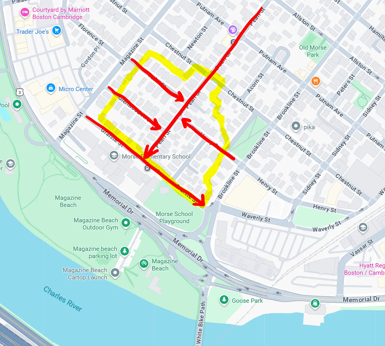
When the rotary gets backed up, this single neighborhood outlet comes to a near-standstill. Granite St does split into 2 lanes for the last 100 ft, one for turning left onto Brookline St and one for turning right towards the rotary, which in theory should allow people not headed for the rotary to skip the line. But there’s often enough cars on Granite St that are headed for the rotary (including cut-through drivers trying to beat the line on Waverly/Sidney) that the left-turn lane is blocked off by the cars waiting to turn right. You can take a 360-degree look around in this street view to observe this exact situation; the rotary is gridlocked, and that left-turn lane is empty — meaning neighborhood residents are stuck in the same slow-moving line as everyone else.
Bus delays destroy the reliability of key routes
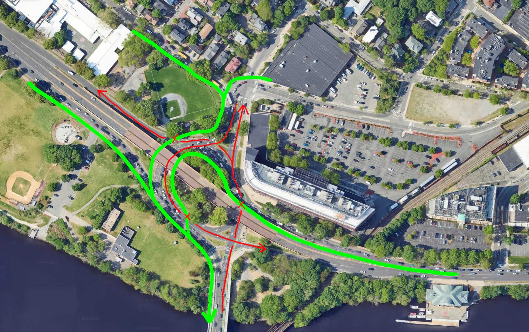
The same gridlock that traps Cambridgeport residents in their driveways also ties up transit, including shuttles, school buses, and the 47 bus. In fact, if you look closely at the above aerial image, you can see 2 school buses and an MBTA bus inching down Granite St onto Brookline St.
Let’s focus on the 47 bus, which on its inbound trip departs Central Sq, goes down Pearl St, turns onto Granite St, then goes through the rotary onto the BU Bridge. This bus is a crosstown route that saw an average weekday ridership of ~5k riders pre-pandemic, and ~3.8k in 2025. The MBTA’s route profile of the 47 bus, released in 2018 as part of planning for their bus network redesign (BNRD), describes this route as follows:
Route 47 is a very high ridership route that provides important crosstown service to major employment centers, and connects to the Red Line, Green Line (multiple branches), Silver Line, and Orange Line, and the many bus routes that serve these rapid transit stations. A major issue is that service is unreliable, particularly on weekdays. Service is also relatively infrequent considering the route’s high ridership.
The route profile mentions that in Fall 2017, only 50% of weekday trips were completed on-time. And while not all of the delay can be attributed to this specific intersection, it is definitely responsible for a good portion of it. We can look at the scheduled vs. actual arrival times for inbound buses at the Mountfort St stop (the 47 bus’ first stop after crossing the BU Bridge into Boston). However, the MBTA also somewhat accounts for traffic delays in their scheduling, so this doesn’t show the full picture. By looking at the MBTA’s 2025 bus data12 for travel times between Central Square and Mountfort St, we can get a decent picture of delays around the BU Bridge rotary:
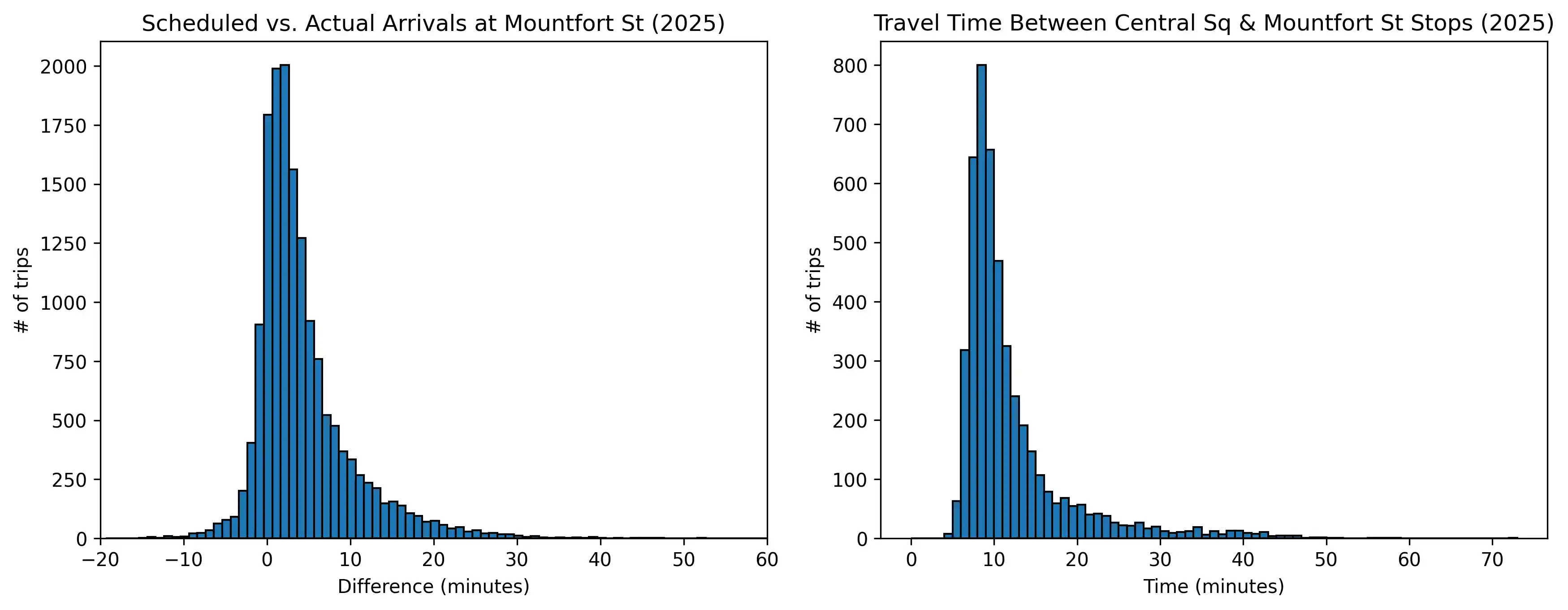
When there’s no traffic, this is a 5 minute drive. But instead, the average travel time between the two stops is 12 minutes, with the median being 9.7 minutes and 90th percentile being 20 minutes. In other words, a significant chunk (10%) of buses get stuck in this stretch for more than 20 minutes, which likely translates to a much higher % of bus riders given peak delay times largely coincide with peak ridership times. During the evening rush (5 p.m. on weekdays), the numbers are even worse: average time is 14 minutes, median is 13 minutes.
In addition, Route 47 is slated to be upgraded to a high-frequency bus route, meaning a bus every 15 minutes or better all day, every day. This will alter the ends of the route (extending to Union Square, truncating at Ruggles), but it will still need to get between Central Square and Longwood via the BU Bridge. And given current conditions, this high-frequency bus route will be unable to hit its service reliability targets, and is basically doomed to fail. How are buses supposed to come every 15 minutes if they frequently get held up at this intersection for 15 minutes or longer?
If the bus gets stuck in the same traffic as all the other vehicles, and is unreliable on top of that, why would anyone take it unless they had no other option? These kinds of delays deter mode shift/push more people to drive, contributing to increased congestion in a vicious cycle. This is something that needs to be addressed now, before the MBTA makes these service changes — which will likely happen sometime within the next 3 years, if not sooner.
Safety issues with the existing intersection
All that being said, the first and foremost issue with this intersection isn’t rush hour traffic, but safety. Below are the statistics13 for crashes within the formal project limits since 2010:
- 371 total crashes (196 within the rotary)
- 105 injury crashes + 1 fatal crash (52 within the rotary)
- 9 involving pedestrians (8 injuries)
- 37 involving cyclists (1 fatality, 28 injuries)
It was extremely telling — and disappointing — that the presentation included ZERO analysis of crashes here, unlike other MassDOT projects dealing with similarly problematic interchanges (see this example in Medford, and this example in Boston). You cannot improve safety without actually examining where and how crashes occur.
The safety of vulnerable road users (VRUs) is a serious problem here in particular. Note of the rates of injury (or worse) for different modes:
- 89% for crashes involving pedestrians
- 78% for crashes involving cyclists
- 21% for the remaining vehicle-only crashes
Let’s dig into some of the contributing factors behind why this intersection is so dangerous.
Deadly speeding
A big chunk of safety issues really boil down to excessive speed as the root cause. High speeds increase both of the following:
- the likelihood of a crash occurring in the first place: speeding = narrowed driver field of vision, longer stopping distance, less time to react, etc.
- the severity of the crash when one does occur
There is a steep relationship between vehicle speed and how serious the consequences are for the struck pedestrian, which is further exacerbated by the growing size of the vehicles on our roads. The below table (data from IIHS) outlines the risk of serious injury or fatality for pedestrians struck by vehicles of different heights at various speeds:
| Vehicle speed | Median-height car | Median-height pickup |
|---|---|---|
| 20 mph | 16% | 27% |
| 25 mph | 25% | 52% |
| 30 mph | 37% | 75% |
| 35 mph | 52% | 91% |
| 40 mph | 66% | 97% |
| 45 mph | 78% | 99% |
The Reid Overpass, along with the stretches of Memorial Drive leading up to it, absolutely has a serious speeding problem. Below is speed data presented by DCR in 2019:
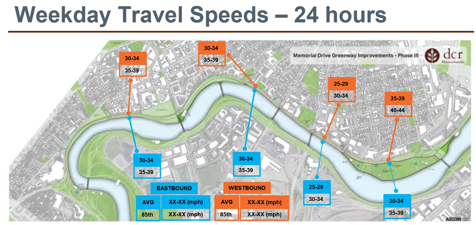
Speeds are clearly very high along the entire Memorial Drive corridor. And these numbers are the average and 85th percentile speeds, meaning that a significant portion of drivers are actually going faster than 40-45 mph. Cross-referencing these speeds with the above table yields serious injury/fatality risk levels that are absolutely unacceptable from a safety perspective.
This is a symptom of the existing road design, which largely consists of straightaways with very long stretches between anything that would require slowing down or stopping. Memorial Drive is also extremely underutilized outside of peak hours, with the wide and largely empty roadway encouraging further speeding. Take a look at this video of driving through the project area on a weekday at 11am - that white car up ahead is definitely going well over the posted 25 mph speed limit.
The worst speeding happens westbound by Magazine Beach, likely due to cars coming downhill off the Reid Overpass. And while the above data collection stopped short of the rotary, similar behavior is likely mirrored east of the overpass as well.
The safety issues in the project area cannot be solved without addressing the speeding issue. It may be tempting to punt that responsibility to the police, but enforcement is both resource-intensive and inconsistent/unreliable. And while a reckless driver certainly doesn’t deserve sympathy, enforcing a 25 mph speed limit on a roadway that fundamentally encourages significantly higher speeds is basically entrapment. Instead, speeding must be mitigated through roadway design that inherently demands slower and safer driving.
Speed was almost certainly a contributing factor in the 2024 death of John Corcoran on the sidewalk-level shared-use path by the BU Boathouse, when a driver lost control of his vehicle as he was coming off the Reid Overpass, jumped the curb, and struck Corcoran head-on. The driver claimed he was distracted by an insect in his car. But if he had been going at a slower, safer speed, such as the 25 mph people have requested as the design speed here (as opposed to a speed limit that’s signed but not actually enforced), it’s incredibly unlikely that such a distraction would’ve had such deadly consequences. Perhaps the driver wouldn’t have lost control in the first place, or the victim might have had time to react.
MassDOT or DCR - frankly, it doesn’t really matter since from the average resident’s perspective it’s a state-level problem - needs to take decisive action to address the speeding/safety issues on the Memorial Drive corridor. Or if not, they need to own up to their unwillingness to do anything that might reduce vehicle capacity, and wall off the riverfront with a guardrail, turning Memorial Drive into another Storrow Drive. This would be terrible, but at least it would be an honest admission of priorities. Kicking the can down the road (such as cutting the Memorial Drive Phase III project short to only touch the “low hanging fruit” portion west of JFK St) just prolongs the current dangerous situation, which is the worst of both worlds: a high-speed roadway that regularly sees 45+ mph speeds that guarantee serious injury or fatality, mere feet away from a busy shared-use pathway.
Disorganized, unpredictable traffic movements
The oversized nature of the roadway includes the main intersection as well: even though the existing rotary is striped for 2 lanes, it’s wide enough for 3 lanes, even 4 in some spots. This causes driving through here to devolve into a free-for-all, with undefined paths of travel and confusion around who has the right of way, and encourages misbehavior like cutting in line at the last minute, sudden swerving/lane changes, etc.
Clarity and predictability are a huge part of being able to safely navigate traffic, and it’s severely lacking here. For example, from a pedestrian’s perspective, the large diameter/shallow turn radius of the rotary makes it hard to tell until the last second whether a car will continue circulating or head straight towards the exit you’re trying to cross at. And misjudging this can have serious consequences.
Another example is the spot where cars make a right turn from the BU Bridge onto the Mem Drive EB on-ramp, turning across the bike lane. With over 500 vehicles/hour turning at peak, this creates a serious right-hook risk, which has been brought up as a major safety issue many times over the years. Once again, lack of predictability is the problem: the combined thru/turn lane makes it ambiguous until the last second whether a car will continue straight vs. turn across the bike lane, especially since very few drivers use their turn signals in a way that would actually give cyclists a chance to react and adjust accordingly.
VRUs are thrown into this mess with little priority or protection
All the above factors create an environment that’s hostile and unsafe for pedestrians and cyclists to navigate. It’s surprising the number of VRU crashes wasn’t even higher; this is possibly due to a combination of:
- pedestrian/cyclist crashes being underreported - for example, this thread alone mentions 2 right hook crashes at the BU Bridge > Mem Drive EB turn since 2023, yet the state crash portal only lists one 2022 crash as the only cyclist crash at this corner since 2015, which seems very hard to believe
- a degree of self-selection - the unsafe conditions likely deter less confident cyclists so that most of the riders through here end up being people willing to tolerate a high level of traffic stress and are highly street-savvy/experienced dealing with Boston drivers - a far cry from the goal of “all ages all abilities” infrastructure
And while the short-term safety improvements that DCR installed in Fall 2024 addressed some problems, such as the narrow sidewalk over by the railroad tracks, many still remain. Rotary entrances/exits remain unsafe to cross for pedestrians. The on-street bike lane sections remain unprotected. Drivers are still preoccupied with navigating around other cars and staking out their spot in the traffic line, and don’t look out for anyone not in a car.
The low position of VRUs in the pecking order is reinforced in many ways by the existing design. For example, the crossings are wide enough to be 2 lanes, despite being striped for 1, which leads to behaviors like drivers trying to go around a crossing pedestrian rather than stopping for them. And critically, the paths of travel for cars across the rotary crosswalks have little to no curvature that would slow them down, making drivers less likely to yield:
- A 2015 study conducted in Boston found that rates of drivers yielding to pedestrians trying to cross sharply decreased the faster someone is driving: “yield rate was 75% at 85th percentile speed of 20 mph compared to 17% at 37 mph.”
- A 2024 study in Minnesota examining several different factors impacting yield rates found that approach speed was very strongly correlated. Study sites with average speeds of ~12 mph had yield rates around ~65-70%, while on the opposite end, those with average speeds of 25-35 mph had yield rates of <20%. At the level of individual crossing events, every 1 mph increase in vehicle speed corresponded to a 21% reduction in the modeled odds that a driver would yield. They also found that “lower yielding rates were noted on wider roads and multilane roads.”
- A 2017 study in Wisconsin (Milwaukee and Madison) also found that “drivers were less likely to yield at intersections with higher traffic volumes and higher posted speed limits.”
In addition, the Wisconsin study looked at yield rates before vs. after a high-visibility police enforcement campaign specifically targeting yielding to pedestrians at crosswalks, and found no statistically significant difference (yield rates went from 40.2% to still-pathetic 42.5%), once again emphasizing this is a problem that needs to be addressed through road design, not offloaded to the police.
Even the tiny sliver of space that is dedicated to VRUs, the 6-12 ft wide sidewalk-level paths (next to the 40-110 ft wide roadway), isn’t safe thanks to the rampant speeding happening right next to it. Again, John Corcoran was on the sidewalk when he was killed. There have been several other incidents where cars on Memorial Drive went careening across the shared-use path, and it’s only pure luck that no path users were struck at those times:
- This Google Street View shows the Magazine Beach fence damaged from a car crashing into it, which went on to hit a tree inside the park. Had there been someone there on the path or even the park at the wrong moment, this could easily have been a fatality.
- When an SUV crashed into the river near Flagg St in September 2021, “the driver narrowly missed hitting a woman and her child who were on the nearby path” - and was just 10 ft away from a student rowing team on the water.
- That was barely a month after a different SUV was knocked into the river by a red-light running pickup truck at Western Ave, with the struck vehicle also spinning out across the (thankfully unoccupied at the time) shared-use path before crashing through the fence and going into the water.
Dangerous high-speed blind merges
While slightly over half of crashes in the project area were within the actual rotary, there are also crash clusters at the merges on either side of the overpass.
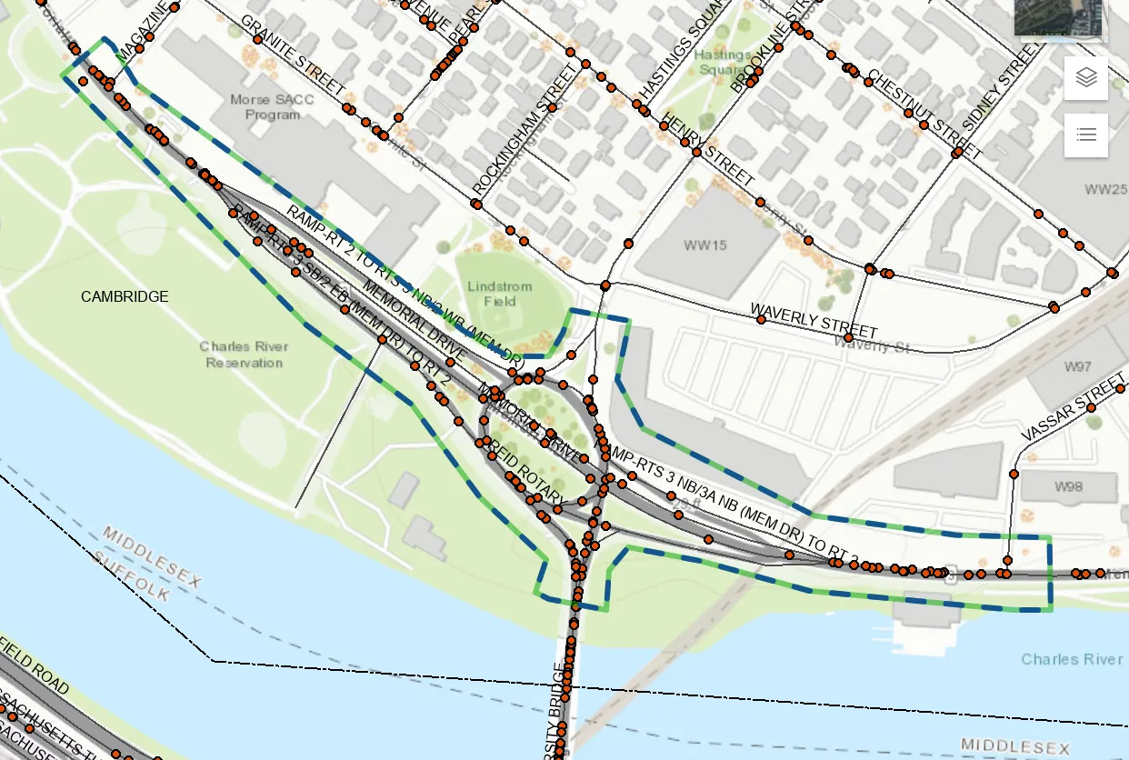
2 different streams of traffic meet here:
- cars coming off the Reid Overpass, speeding because of the downhill straightaway and the excessive roadway width (the overpass has 2x the lanes that would be needed for existing traffic volumes)
- cars driving on one of the Memorial Drive on-ramps, also often speeding thanks the excessive 22-ft width of the on-ramp lane
These speeding cars are hidden from each others’ view due to the overpass structure itself. For example, see this video showing the POV of an eastbound driver on the overpass approaching the merge. Sightlines are even worse for those on the on-ramp. Then following the first point that the merging cars can actually see each other, they have <350 feet to merge. This is fairly short and abrupt: appropriate for 25 mph speeds, maybe, but certainly not for a road with an 85th percentile speed of 40-44 mph. This speed + bad sightlines combination creates crash risks, especially dangerous on the eastbound side because of the higher on-ramp traffic volumes and the fact that the merge is immediately adjacent to a busy sidewalk/shared use path.
MassDOT’s designs vs. these key issues
So with all the above in mind, let’s take another look at MassDOT’s proposed “conceptual alternatives” (higher-resolution versions can be found in the posted presentation):
Once again, all these designs fail to address the aforementioned issues. If anything, they would make passing through here even more unpleasant for pedestrians and cyclists, to the point of deterrence.
A case of backwards priorities
The really frustrating thing is that the state is aware of everything described in the previous section. People have shared their safety concerns for years and years, through so many different channels, and MassDOT even listed several of them in their presentation slides. But the actual designs show a lack of urgency or care when it comes to safety.
This is explicitly codified in the project team’s process: on slide 19 of the presentation, they list out all the project objectives, and sort them into 3 levels of importance. The presenter stated that “constraints are non-negotiable requirements that cannot be violated without significant justification.” One of the constraints listed on the slide is “equal or better intersection level of service (LOS).”
In contrast, he said that “necessities represent what stakeholders expect the project to achieve, so long as those goals stay within established constraints: examples include improving bicycle and pedestrian facilities, and enhancing overall safety and accessibility.”
In other words, motor vehicle throughput is being prioritized over safety, which is the opposite of what should be the case: improving safety should be a non-negotiable component, and it’s the addition of lanes (again, in every single option) that should require “significant justification” from MassDOT for why it’s being proposed despite increasing the risk/exposure for pedestrians and cyclists crossing through here.
No relief for Granite St gridlock
MassDOT’s approach to “fixing” the issue of rotary backups blocking in Cambridgeport residents seems to be to try and increase the overall throughput/capacity of the intersection, and hope that any resulting congestion relief will trickle down to the neighborhood.
For example, all 4 designs add a new slip lane from Brookline St onto Mem Drive WB, with the reasoning likely being that allowing that movement to bypass the rotary will help the line of cars entering the intersection from the north get through faster. But that movement only accounts for 27% of cars from Brookline St in the AM peak hour, and even less (13%) in the PM peak hour, so what’s actually going to happen to that slip lane is the exact same thing that happens to the left turn lane that already exists at the end of Granite St: access to it will be blocked off by the other cars (the overwhelming majority) headed for a different exit, and it will just sit uselessly empty for most of the time.
MassDOT also noted that one of the things they heard from Cambridgeport stakeholders was “separating regional and local traffic,” but they interpreted this to mean only “keep the Reid Overpass.” They overlook the fact that it’s not just Memorial Drive that carries regional traffic, but the BU Bridge as well. Yes, the Inner Belt project was stopped, thankfully, but the north-south travel demand it was intended to address still remains, and not everyone uses Route 28 or I-93 for that: there’s a significant volume of non-local traffic that filters through Cambridge, including cars cutting through Cambridgeport to get to/from the BU Bridge.
The traffic flows here need to be carefully considered to balance local neighborhood access against this regional N-S travel demand, but MassDOT’s designs fail to do that. If anything, increasing the capacity for cars on Brookline St to get into the intersection will only encourage more cut-through traffic in Cambridgeport.
No attempt to address bus delays
There’s another glaring issue with all of these designs: absolutely zero facilities supporting public transit. And when asked about this omission during public comment, here was the project team’s response:
These options do not necessarily advance public transit opportunities, but there are opportunities for us to coordinate with the MBTA to see what their future plans may be. And obviously, if there are any opportunities to enhance public transit facilities, we’d obviously include that in any options as we move forward.
Rather than proactively addressing this problem, MassDOT seems to believe that transit is a separate issue for the MBTA to deal with, and that it’s on the MBTA to let MassDOT know if they need something here. Yet the above quote also implies that at the time of the January public meeting, at a stage of the project where several design concepts had already been eliminated, MassDOT had not even reached out to the MBTA yet. How is the MBTA supposed to comment on a project they haven’t been looped in on?
Even without direct MBTA involvement, the project team should have been aware of the importance of addressing the bus delay through here. It’s a long-standing issue that has been raised through many different channels over the years:
- Was repeatedly brought up during DCR’s Mem Drive Phase III project engagement, before the project scope was cut short to exclude this area
- It almost certainly came up during the 2024 CNA meeting as well, given that the 47 bus runs right down the middle of Cambridgeport and serves many of its residents
- The city of Cambridge has a strong interest in this issue - for example, see this list of priority projects from a Nov 2019 Transit Committee meeting that mentions the need for a rotary bus lane
- The MBTA recently went through a major, highly-publicized engagement process for its Bus Network Redesign - the upcoming high-frequency upgrade for route 47 is not some secret
Discussions with the MBTA, as well as Cambridge and transit advocacy groups, should have been happening already, well before the January meeting. Even if MassDOT narrowly defines the scope of its responsibilities to motor vehicle traffic, the performance of transit is directly linked to vehicle congestion: if the MBTA completely shut down tomorrow, so that its ~million daily trips turned into drives, guess what would happen to traffic on our roads?
But because transit accommodation is still being treated as an afterthought, something to tack on later (if at all), this creates a completely backwards order of operations that lead to dysfunctional outcomes. For example, the team’s current process/prioritization have already led to 3 (out of 4) designs that don’t even fit within the existing ROW as-is, with additional property acquisition likely needed — so then how is a bus lane going to fit in on top of that?
Again, MassDOT’s only “strategy” for improving transit here appears to be hoping for trickle-down benefits from increased overall intersection throughput.
It’s the same problem as the aforementioned low prioritization given to future-proofing for Grand Junction transit: a frustrating lack of coordination and vision at the state level, that blocks regional transportation improvements as well as undercuts Cambridge’s own efforts towards Vision Zero and reducing traffic.
Large intersections induce more box-blocking
Box blocking is when vehicles continue to enter the intersection despite there not being enough room for them to fit on the other side, which then blocks other traffic movements through the intersection and creates gridlock. This is extremely common behavior at several intersections in the area, basically occurring anywhere multiple directions of traffic are competing to get into the same bottleneck. The BU Bridge/Memorial Drive intersection definitely falls into this category.
While traffic would obviously flow best if everyone just followed the rules, there’s enough people who disregard them that every driver then becomes incentivized to block the box: not doing so means missing your turn (sometimes for several cycles on end) and also probably getting honked at by drivers behind you. It’s a real prisoner’s dilemma type of situation.
Larger intersections make the box blocking problem even worse:
- a bigger intersection box means more vehicles can fit in it,
- which means even more time is needed for box-blocking vehicles to clear the intersection after the red,
- which then means increased backups on the blocked road,
- which then makes those drivers more likely to block the box themselves.
MassDOT clearly is aware that box blocking is a problem: they cite “opportunities for the box blocking we observe today” as one of the reasons for eliminating alternative A1. Yet they act like it won’t be a problem for any of their other large signalized intersection proposals, which simply is not true.
And box blocking doesn’t just screw up traffic, it’s a major safety problem for vulnerable road users as well. Box-blocking vehicles are usually also blocking crosswalks (and in the case of big trucks, even blocking the crossing signal from view entirely), making crossings miserable and unsafe for all other road users. For example, take a look through the photo album linked in this post, showing typical conditions for people attempting to cross at the intersection of Museum Way and Charles River Dam Road/Rt 2814.
Dangerous ramp merges made worse
In the designs with an overpass (3 out of the 4 options), these blind high-speed on-ramp merges onto Memorial Drive are pretty much left as-is. Nothing was done to reduce overpass speeds, and on-ramp speeds will in fact increase due to the turns onto those ramps being outright converted into slip lanes.
Even worse - all the overpass designs actually shift the EB overpass ramp towards the river path/sidewalk, sometimes by as much as a full lane’s width, in order to make room for an additional turn lane on the north side.
This aims downhill speeding overpass traffic even more squarely at the spot John Corcoran was struck, and makes these dangerous merges take place even closer to where people are walking and biking.
Safety being traded for throughput…
Every single one of the proposed designs increases the number of lanes in the intersection in an attempt to reduce congestion (which again, is useless because of the BU Bridge bottleneck). And this increase directly reduces safety, particularly for pedestrians and cyclists, in several different ways.
First, it makes roadway crossings longer, even though in some designs this is obfuscated by the crossings being split across multiple “refuges” and traffic islands. These longer crossings mean more exposure for pedestrians and cyclists: every additional lane to cross is an additional opportunity for a conflict with a motor vehicle.
In particular, several of these new lanes are slip lanes. When one attendee raised concerns about the safety issues around making pedestrians navigate the multiple slip lanes present in every single one of the presented design options - concerns informed by real-world experience navigating actual existing ones in the area - the project team simply replied:
Typically those slip lanes are yield control for efficiency and simplicity. And so you are coming in at a slower speed and they should yield. They should be notified, though, if pedestrians are crossing and have the right of way.
“Should” is really doing a lot of work there. Anyone who regularly walks in the area knows that pedestrians having the legal right of way in the crosswalk does little to stop drivers from blasting through them all the time. A design that relies on idealized driver behavior is bound to fail, with vulnerable road users paying the cost of that failure.
Just look at what MassDOT proposes for the previously mentioned cyclist right-hook hotspot:
Rather than implementing anything like signal separation (something other advocates have previously proposed here), physically hardening the turn, or even at least separating out that movement for reduced ambiguity, MassDOT is actually going in the opposite direction: in every single design, they further soften this turn into an outright slip lane, making it so cars no longer have to slow down as much. Then on top of that, the bike lane is routed right across that slip lane with zero warning. The above design is a wrongful death just waiting to happen.
This perfectly encapsulates how little thought or care was given to the safety of vulnerable road users in these designs.
Also, another detrimental side effect of all these slip lanes is the creation of additional traffic islands and curb cuts, which will be filled with plowed snow off the roadways every winter.
Outside of peak hours, the widened roadways will be mostly empty/very underutilized, encouraging speeding. And during peak hours, that extra room in the intersection itself provides more room for chaotic driving. Option B2 (2-lane “roundabout”) will still have cars cutting in, and the other 3 designs will have people abruptly switching lanes, sometimes in the middle of the intersection in the case of B3 (the diamond), when they realize their lane is left turn only instead of straight or vice-versa.
It’s obvious that these concepts were designed with motor vehicle capacity in mind first and foremost, with the intent to throw in a few “multimodal” mitigations after the fact if any concerns are raised. But again, these things can’t be considered in isolation. Putting up more signs and flashing lights cannot fully offset the negative impact road expansions inherently have on pedestrian/cyclist access and safety, especially given local driver behavior…for example, just look at the compliance rates for “no turn on red” restrictions around here, as seen in this recent video (which was incredibly easy to find) from the nearby Memorial Drive/Mass Ave intersection: multiple cars completely ignore the signage to turn across an active crosswalk.
Instead of designing a high-speed slip lane and then having to add an RRFB when drivers inevitably fail to yield, don’t include a slip lane in the first place. Or at least significantly harden the turn to force cars to slow down to speeds that are safe for pedestrians and correspond to high yield rates.
Negligible parkland reclamation, intersection expansion instead
MassDOT probably considers this aspect outside of its responsibilities, but mentioning it anyways the hopes that DCR will advocate more strongly for the parkland in its care: another consequence of MassDOT’s “more lanes” approach is very little riverfront space/parkland gets reclaimed. While their designs do have a small (~3-11%) amount of roadway area reduction, thanks to the extremely low bar set by the massively oversized rotary that exists today, in most cases that area has been replaced with traffic islands. And sure, conversion of asphalt to grassy traffic islands does count as less impermeable surface area, and that 3-11% reduction might lead to tiny water quality improvements for the Charles River watershed…but we can and should aim higher.
Although this is a MassDOT project due to there being bridge structures involved, Memorial Drive is a DCR parkway and most of this intersection sits within DCR-managed parkland - public lands originally intended for conservation and recreation. See the below map. Reducing impermeable surface area by the river is really the bare minimum; the actual goal should be to reclaim/restore green space that is contiguous with the riverfront and supports recreational uses.
Traffic islands do nothing to advance that goal. Just look at the stark difference between the wide Memorial Drive median by MIT vs. the Esplanade on the opposite bank of the river. The former sits nearly empty year-round, with the only time it ever gets foot traffic being the 4th of July when Memorial Drive is closed for the fireworks display. It’s such an incredible waste of what should be vibrant riverfront space. Meanwhile, the latter is full of activity, bordering on overcrowded, the moment the weather is nice.
In fact, MassDOT appears to be headed in the opposite direction, with the overall intersection footprint actually expanding in most cases. For 3 out of the 4 designs, MassDOT’s slides noted they might need to cut further into adjacent properties or parkland:
- Option A3 - “Requires more space - constraints with nearby properties”
- Option B1 - “Additional ROW likely required”
- Option B2 - “Potential ROW impacts near abutments”
Considering how massively oversized the existing rotary is, the fact that these designs are still somehow too big to fit in the existing envelope should be a huge red flag.
It’s already bad enough that the riverfront on the Boston side is severed from the city by the 4 lanes of Storrow Dr + the 8 lanes that Comm Ave swells to at the BU Bridge intersection (not to mention the 8 lanes of the Pike cutting through here). Proceeding with these designs would mean more of the same on the Cambridge side, framing this section of the Charles River between rivers of pavement.
Additional specific comments on individual alternatives
B2: 2-Lane Rotary with 4-Lane Overpass
Let’s start with Alternative B2 as it’s the easiest to compare/contrast with the existing conditions today, and really highlights the disconnects between the stated priorities for this project, the actual designs, as well as MassDOT’s evaluations of them.
Same design, same problems
This design is fundamentally a replica of the existing intersection: the below screenshot of the currently existing lane markings (source) shows that what we currently have is indeed also a 2-lane rotary with a 4-lane overpass.
MassDOT’s “new” proposal B2 merely cleans this up a little so that the rotary is a circle rather than egg-shaped, and shrinks the diameter a bit. But the fundamental form is unchanged, meaning that this would solve absolutely none of the issues that plague the intersection today.
For example, despite increasing the number of entry lanes into the rotary, all those lanes still funnel into that single southbound lane of the BU Bridge. All that 2nd rotary lane will do is exactly what it does today: serve as an additional line for cars queueing to into that lane, with most of them cutting in at the very end. And the dangerous blind merges between the exit ramps and Reid Overpass traffic still remain.
All this makes it extra baffling that MassDOT decided this alternative is one of the concepts worth further investigation.
Still too big and high-speed to be a true roundabout
While MassDOT has labeled this design a “roundabout,” it is still closer to an unsafe high-speed “rotary”: with a diameter of ~215 ft, the proposed circle is too large to effectively slow down traffic to safe levels. Here’s what the FHWA has to say about roundabout sizing:
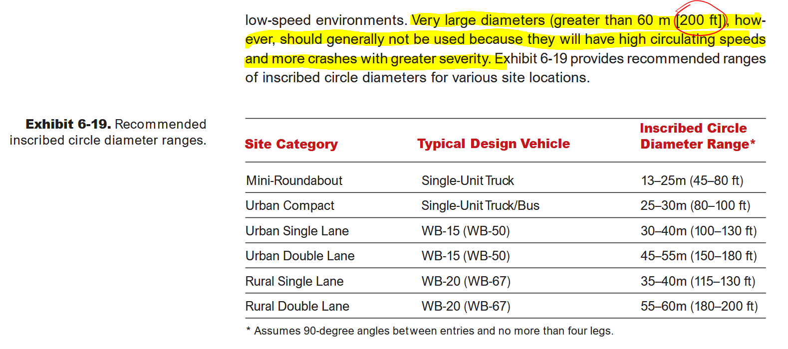
The FHWA is very conservative when it comes to changes that might impact vehicle throughput, so if even they say over 200 ft is too large, and that an urban double-lane roundabout should be in the 150-180 ft range, that should be taken very seriously.
Even worse for peds/bikes than today
The few actual changes this design does make all significantly degrade, rather than improve, the safety of pedestrians and cyclists trying to cross here:
- The existing signal that river path users rely on to cross here is removed. Instead, that crossing has been split into 3 crossings, 2 of them across lanes that will be full of high-speed traffic barreling downhill off the BU Bridge. High speeds = low yield rates for pedestrians waiting to cross, as well as deadlier crashes.
- 2 new slip lanes have been added, facilitating high speeds for turning cars, as discussed above.
- The rotary entrances from Memorial Drive have been increased from 1 to 2 lanes, while still remaining yield-controlled. This is actually very bad for the safety of people crossing.
Creating brand-new double-threat crash risks
That last point is the real dealbreaker for this design option. If vehicle-vehicle crashes were the only consideration, then option B2 would at least be better than the others, which are all different forms of signalized intersection. While a 1-lane roundabout is safest (more on that later), 2-lane roundabouts still have an advantage over standard signalized intersections in terms of efficiency and safety for drivers15. But once again, there are thousands of pedestrians and cyclists crossing through here daily, and their safety is non-negotiable.
The reason why it’s so bad for pedestrians: any crossing of multiple lanes in the same direction that is dependent on driver yield behavior (even if you add a yield sign or flashing yellow lights) is a recipe for a double-threat crash like the one illustrated below (graphic source).
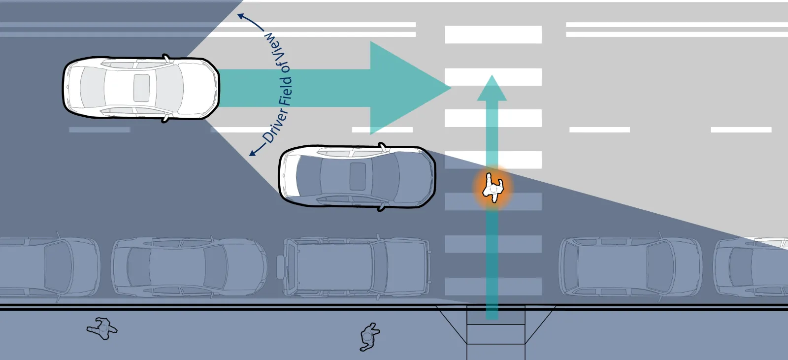
Here is how a double-threat crash happens:
- One car yields at the crosswalk, so the pedestrian starts to cross
- That 1st stopped car creates a blind spot that blocks the pedestrian from the view of drivers in the next lane over
- As the pedestrian and oncoming driver cannot see each other, both continue on a collision course
Such multi-lane yield-controlled crossings have been responsible for several serious pedestrian crashes in the Boston area.
In theory, this safety issue can be addressed by adding a full stop signal for the crossings. For example, the Fresh Pond rotary has traffic signals for pedestrian crossings next to it (a 3-lane one to the west and a 4-lane one to the east), which are definitely appreciated; very few pedestrians and cyclists would be comfortable crossing here if these were merely yield-controlled. However, having traffic signals positioned that closely defeats the efficiency advantages of a roundabout, which MassDOT is unlikely to accept (see the next paragraph, in fact). Alternatively, you could move the crossings further away, but this would be forcing significant out-of-direction travel for pedestrians and cyclists for the sake of driver convenience.
Removal of the PDW path crossing signal
The most concerning change for pedestrian and cyclist safety is the downgrading of the signal-protected crossing for the PDW river path to yield control. Path users continuing along Memorial Drive will have to cross these 3 lanes of the BU Bridge one at a time, hoping that drivers (including the ones barreling downhill off the bridge straightaway) will yield to them.
Yes, a signal immediately adjacent to a roundabout entry/exit is bad for traffic operations, but this is simply not acceptable, especially given the volume of path users that cross here. Again, it would be great if MassDOT shared the most recent count data, but old count data spanning 2009-2014 found that during the weekday evening peak, the Charles River Middle Basin north bank path (west of the BU Bridge) averaged 414 users (all modes, walk/run/bike) in 2 hours, while the Lower Basin north bank path (east of the BU Bridge) averaged 848 users in 2 hours.
Either way, we’re looking at a few hundred people crossing per hour. If drivers yielded every time there’s someone waiting to cross, then that would severely limit the traffic flow on/off the bridge. What’s more likely to happen, though, is that most drivers won’t yield (because again, high speeds = low yield rates), and if path users want to cross in a reasonable timeframe, they’ll have to take risks and dart through too-narrow gaps in traffic.
This design is going to lead to more pedestrian/cyclist injuries, as well as more rear-end crashes.
MassDOT either is unaware of, or is glossing over, these problems
Despite all the above, this is how the project team rated this design (text taken directly from the presentation slide):
Benefits
- Keeps Memorial Drive traffic above & out of intersection
- Reduced conflict points
- Minimizes conflicts & crossing distances for peds/bikes
- Lower idling and emissions
- Efficient local circulation below
- Aesthetic/Landscape opportunities
Limitations
- Complex bridge/ramp design increases cost
- Potential ROW impacts near abutments
- Tight geometry limits large vehicle movement
- Requires careful ped/bike connectivity under structure and at crossings
This raises several questions. Reduced conflicts and crossing distances compared to what baseline? Because it’s certainly not reduced compared to existing conditions. There is no mention of the high speeds and double-threat crash risk discussed above, and MassDOT claims “efficient local circulation” with zero acknowledgement of how the nearly-identical existing 2-lane rotary very much does NOT have efficient circulation.
Also: the inclusion of “lower idling and emissions” in the list of benefits hits on a pet peeve of mine. It’s nearly as bad as the “safety concerns from driver frustration” that was cited near the beginning of the presentation. These points often get brought up in response to any road changes, and basically boil down to: doing anything that might slow down drivers means they will pollute more and/or get road rage, so therefore keeping them moving quickly is clearly the best option for everybody.
Having increases in vehicular throughput be repackaged and sold to us as better for the environment and for our own safety is insulting, to put it mildly. We have decades of evidence that no, there’s no trickle-down environmental benefits and vulnerable road user safety benefits to road expansions, and that actually, the opposite is true. The only actual long-term solution to reduce the injuries/fatalities and environmental harm caused by our over-reliance on cars is mode shift.
B3: Tight Diamond Intersection with 4-Lane Overpass
The tight diamond intersection is essentially a worse replica of another, already-bad intersection just 1 mile away, the intersection of Memorial Drive with the Mass Ave Bridge.
Take a look at that intersection, and then imagine it with the following changes:
- instead of Mem Drive passing under Mass Ave, have it go overhead on a viaduct, blocking several sightlines
- add in heavy volumes of left-turns from multiple new directions (especially Mem Drive WB > BU Bridge SB - the equivalent is prohibited at Mass Ave)
- add 4 new slip lanes, 1 at every corner
- change the river path crossing from a single 3-lane crossing into a 4-stage, 5-lane crossing
That is essentially what alternative B3 is.
The Mem Drive/Mass Ave bridge has consistently been listed in the top 200 worst intersection crash clusters across the entire state, and ranked #37 in the most recently published version (2019-2021). And right across the river, 3 consecutive intersections on Soldiers Field Road (Cambridge St/River St Bridge, Western Ave, and N. Harvard St/Anderson Memorial Bridge/JFK St) are also compact diamond intersection variants that are all in the top 5% high-crash intersections in the Boston MPO.
It’s very difficult to believe MassDOT’s claim that a bigger, more complicated version of these intersections will actually be a safety improvement.
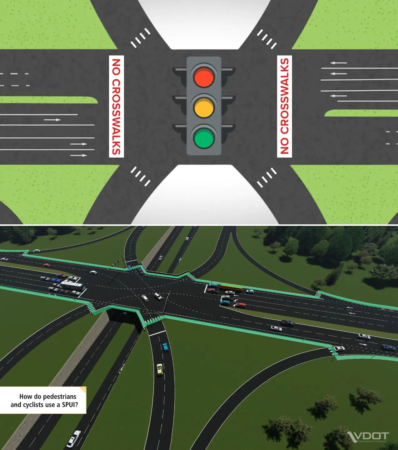
B1: Single Point Intersection with 4-Lane Overpass
B1 is a type of single-point urban interchange (SPUI), which replaces the 2 closely-spaced intersections of a diamond interchange (like B3) with 1 big one that’s controlled by a single set of lights. The advantage of a SPUI is that opposing left turns can go simultaneously without their paths crossing, which makes the intersection more efficient for vehicles and requires fewer signal phases than something like the above tight diamond. However, a SPUI is absolutely not appropriate for this location.
Incompatible with the road geometry here
Memorial Drive and Brookline St do not meet at a standard right angle. The B1 design as shown has the roadways meeting at approximately 56 degrees, meaning a fairly high skew angle of 34 degrees. This is higher than what specified in most design guidance for SPUIs; for example, MODOT states that the absolute maximum allowable skew angle is 30 degrees, and even below that threshold, says “Extreme care should be exercised in planning to use a SPUI when the skew angle approaches 30 degrees.”
MassDOT’s own guide/PDDG states that “SPUIs built with a skewed angle between two roadways increase clear distances and adversely affect sight distance.”
This seems like a pretty explicit and clear-cut contraindication, so why was this one of the options chosen to advance to the next stage of development?
These sightline issues are further exacerbated by the tight space constraints and ground slopes at the BU Bridge. The slip lane coming off the BU Bridge and the left turn lane coming from Brookline St merge quite abruptly, in just 30-40 feet. This is an extremely short distance and not a lot of time for cars to react to each other, especially given fast speeds coming downhill off the BU Bridge and the fast left turn speeds that SPUIs enable. And that’s on top of the fact that the left turning cars will be popping out from the shadowed area below the overpass, making them even harder to see from the slip lane.
And sure, the slip lane cars are “supposed” to yield…but again, drivers often disregard signs/rules, e.g. here’s an example of this exact situation at a SPUI, with slip lane drivers ignoring yield signs and nearly colliding with left-turning cars. And sure, the signal phasing will reduce how frequently this conflict occurs (since if there’s a few cars lined up to go straight north off the BU Bridge, that will block off the slip lane while the left turn is active)…but it’s very much still going to happen.
Demands a large, unstructured intersection box
SPUIs require a certain minimum intersection size to support having all the turn movements going through this one box, in particular the shallow, non-overlapping left turns that are necessary for the design to work as intended. This would likely make any future efforts to reduce the roadway footprint more difficult.
This also leads to a large area of pavement with very limited places to place any kind of guiding curbs/dividers that wouldn’t get in the way of any of the traffic movements. SPUIs can also confuse drivers unfamiliar with this intersection design; for example, here is an example of a left-turning driver assuming they’re supposed to pass to the right of the divider (since that is the norm in most cases), nearly getting into a head-on collision.
The large intersection footprint also makes it perfect for box-blocking behavior. Here is a video showing it happening in a SPUI. It’s all too easy to map this situation onto the Reid Overpass area: the POV is pretty much what you’d encounter when taking a left from Memorial Drive WB towards the frequently-backed up BU Bridge SB lane (the movement that also happens to be the heaviest flow entering that lane during the peak hour). And again, this video wasn’t hard to find, and turned up even without specifically searching for box-blocking; the actual search was for examples of overpass SPUIs to try and find some images/videos that show what it would feel like for people going under the viaduct. Unfortunately, every single example was an interchange between an arterial and a freeway - which should be another major red flag, by the way - the closest in size to what’s proposed being this SPUI in Pennsylvania, which also has a 4-lane overpass (albeit a pretty wide one).
Incompatible with the river path crossing
Various design guides for SPUIs explicitly state that there should not be any pedestrian crossings of the non-over/underpass road at the main intersection - in other words, crossings that run parallel to the overpass, which in this case would be the heavily-used crossing of the PDW river path at the foot of the BU Bridge.
Examples:
- Kentucky’s state transportation department - “Pedestrians use marked crosswalks to safely cross freeway ramps. There are no crosswalks across the main road of a SPUI due to safety concerns.”
- Virginia’s state transportation department - “For pedestrian safety reasons, crosswalks are not provided across the arterial at a SPUI. To safely cross the arterial, pedestrians should use the nearest marked crosswalk, which may be provided at an adjacent signalized intersection.”
This is likely one of the reasons that this 2008 report from Rutgers University (“Bicycle and Pedestrian Safety Needs at Grade-Separated Interchanges,” prepared for NJDOT) outright states that “single-point urban interchanges should be avoided.” The literature cited in/attached to this document is also pretty damning about the inappropriateness of SPUIs for places where pedestrian access is important.
If you watch this timelapse of traffic flow through a SPUI and imagine what the equivalent of the river crossing would be, it would be as if you placed a crosswalk in the lower right of the frame, going across the higher-elevation road. And you can see that there is never a point where the entire crossing would be clear of cross traffic.
So in practice, river path users would need to cross in 2 stages: go halfway, wait in a tiny pedestrian refuge in the middle while cars zip by at high speeds, and then cross the second half. And speeds will be high, even for left turning cars - the large/shallow turn radii for these left turns is actually considered a design feature of SPUIs because higher turn speeds = increased left turn throughput = increased overall intersection capacity. But again, higher speeds are antithetical to safety, especially for vulnerable road users. This is a massive downgrade from the existing crossing conditions.
Now technically, you could halt all intersection traffic to insert a dedicated pedestrian phase that would allow river path users to cross the entire road in one go, but that would undermine all the operational advantages of a SPUI. So then why try to use one in the first place? This self-contradicting output is the result of treating pedestrian/cyclist facilities as something to tack on at the end, only after motor vehicle traffic gets “solved,” rather than incorporating these considerations from the beginning.
And here is all MassDOT’s presentation slides had to say about this design:
Benefits
- Keeps Memorial drive traffic above & out of intersection
- Reduces conflict points and congestion.
- Provides dedicated bike lanes
- Continuous accessible sidewalks and crosswalks with protected pedestrian phases
- Shorter bridge reduces cost and visual impact
Limitations
- Elevated structure creates visual and physical barriers, limiting improvements at street level
- Additional ROW likely required
- Complex construction staging
Once again, there’s zero mention of any of the concerns discussed above. It’s also odd to list dedicated bike lanes and continuous accessible sidewalks as some kind of differentiating benefit when that should simply be the bare minimum for any design…
A3: At-Grade - Partial Displaced Left Turn (PDLT)
A3 is the only 100% at-grade, overpass-free option out of the 4 designs MassDOT is advancing. The project team described it as “innovative and progressive” (the presenter’s exact words). In contrast, design B3 was called “not progressive,” with the slides saying that B3’s “conventional design is inconsistent with Cambridge’s multimodal, context-sensitive vision.” The elimination of an overpass would greatly reduce construction and maintenance costs, which is likely another huge plus in MassDOT’s view. Perhaps the reason the other 3 designs were included despite extremely clear contraindications was that A3 has already been selected internally, but the team needed to toss in some other “options” to create the illusion of choice for the public.
Notably, one of the consultants on the project team was also part of the team for the removal of the Casey Overpass in JP a decade ago (in addition to being on the ongoing McGrath Boulevard/viaduct removal project team - maybe he’s MassDOT’s go-to guy for viaduct replacement projects) and the “magic bullet” for that design to pencil out traffic-wise was a median U-turn (MUT). The PDLT16 is similar in nature - an intersection innovation that appears to be a breakthrough for congestion. But while the out-of-the-box thinking is appreciated, it also really emphasizes that improving motor vehicle throughput is the main concern here.
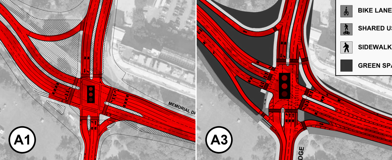
Side note: moving goalposts and comparison to the eliminated A1 option
This emphasis is further reinforced by the rather inconsistent justifications provided for keeping vs. eliminating design concepts.
Option A1 on the left was eliminated with some of the “critical issues” being “opportunities for accessible greenspace are limited” and “cycling/pedestrian crossings long and inconvenient,” yet option A3 on the right, which in comparison has ~17% more paved roadway area and even more lanes that pedestrians need to cross (A1 is 7x4 lanes, while A3 is 7x6 lanes and actually even bigger than that in terms of overall size/crossing distance), is being advanced as the one that supposedly “matches Cambridge community’s vision of innovative forward-thinking infrastructure”? It feels like there might be a thumb on the scale here.
Clearly, the actual reason that A1 was eliminated was traffic throughput: the team cites “Poor overall operations” and “Extremely long queues which do not clear during peak hours.” Yet this seems to conflict with what local civil engineering professor and traffic signals expert Peter Furth found for his signalized intersection design proposal, which is similar to option A1. Is this discrepancy due to using different assumptions, different metrics, or just having different thresholds for what LOS is considered adequate? MassDOT needs to be more specific when communicating their criteria, as discussed at the end of this post.
Setting people up for wrong-way driving
The biggest issue with this design is the risk of potentially deadly wrong-way driving. MassDOT’s presentation noted that a “limitation” of this design is “unfamiliar configuration for drivers,” but that is hugely understating the problem.
Crossovers can work in certain contexts; in fact, the alternative design proposal discussed in the next section includes some. But take a look at the below image showing how the eastern crossover is implemented in MassDOT’s option A3: there is a long 450-ft stretch where 1 westbound lane is sandwiched between 3 eastbound lanes. And the very shallow angle at which this crossover occurs, plus the thinness of the marked buffers/gores separating the different directions, makes it extremely easy for a westbound car that’s trying to use the PDLT to accidentally go the wrong way up one of the eastbound lanes on either side of the “correct” westbound lane entrance.
On top of that, the main intersection also provides several opportunities for wrong-way driving to occur up the displaced left turn lanes, because drivers are used to going to the right of the primary median, and generally don’t expect there to be additional directional flips past that.
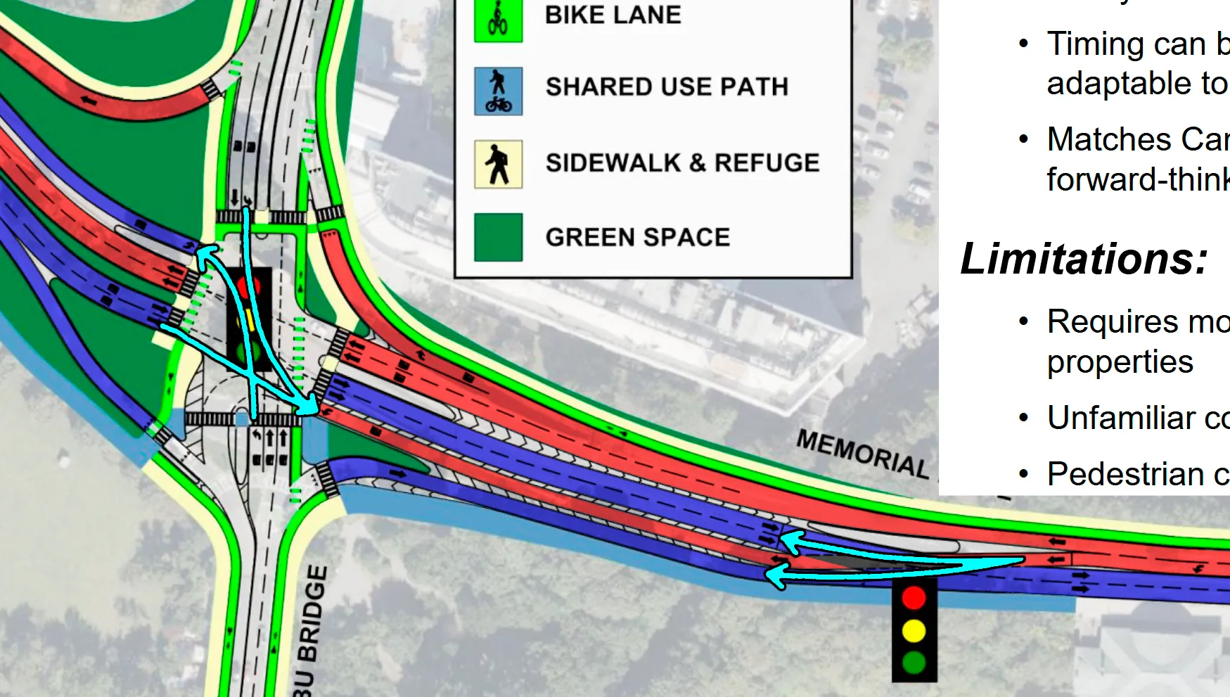
This cannot be “fixed” by simply installing tons of signage: drivers are often distracted, and signs and road markings can be obstructed (by snow, or even road salt all winter). The long length of the intersections further reduces the effectiveness of any posted “do not enter/wrong way” signage, which becomes further away/less noticeable. Again, truly safe designs should make these kinds of mistakes physically impossible, rather than relying on ideal driver behavior and attentiveness.
The solution (to this specific issue, at least) would normally be to make the crossover happen at a steeper angle, build bigger and more prominent buffers, and have that EB lane at the edge merge in much further down from the crossover point. In fact, the western crossover in this same A3 design does all of these things, and is much less risky than the eastern crossover as a result. However, the space constraints on the eastern side mean this is impossible without encroaching onto Goose Park and possibly even the BU Boathouse.
Actually increases conflict points
MassDOT’s slide describes the PDLT as “Minimized conflicts → lower crash potential → enhance safety.” Once again, what’s the baseline for comparison when making this statement? Sure, a PDLT has slightly fewer conflict points vs. a conventional signalized intersection: they both have 8 merging and 8 diverging conflicts, but a PDLT “only” has 14 crossing conflicts, compared to 16 for the conventional intersection. But remember, the existing condition is not a conventional signalized intersection: it’s a 2-lane rotary with an overpass. A 2-lane rotary has 8 crossing conflicts, 8 merging conflicts, and 8 diverging conflicts, then on top of that add 2 merging and 2 diverging conflicts for the overpass merge.
In other words, the PDLT actually introduces 2 additional conflicts compared to today (30 vs. 28), and even more critically, it has significantly more crossing conflicts (14 vs. 8), which are associated with more dangerous crash types (angle/T-bone).
Any design that actually increases conflicts and reduces safety compared to the current conditions is not acceptable, no matter how appealing the traffic flow advantages may seem.
An “Alternative C” design proposal
Can we do better than the above concepts from MassDOT? Many street safety advocates seem to believe so; in fact, several had already drawn up alternative proposals even before the January 6th meeting (likely in anticipation of MassDOT taking a highway-oriented approach, given historical precedent), and there were likely others made afterwards in reaction to the designs that MassDOT presented.
Here are a few that have been published:
- For a 100% overpass-free, at-grade option, there is this proposal from Peter Furth (a Professor of Civil Engineering at Northeastern, who also came up with the signal improvements at the Comm Ave end of the BU Bridge) and one of his graduate students, Nathan David Obeng-Amoako. Their traffic analysis found that a signalized intersection with reasonable LOS can be achieved in a much more compact footprint than any of MassDOT’s proposals, and without inserting excessive slip lanes everywhere.
- There is also this recent proposal from Ari Ofsevit, a Hovenring-inspired design that puts all motor vehicle traffic at-grade while pedestrians and cyclists are routed over the intersection via a series of bridges. However, the author himself acknowledges that it’s very unlikely MassDOT would consider something like this.
- Ofsevit also drew up this quick-build concept for the Memorial Drive Alliance several years ago.
Now there definitely isn’t a single “correct” answer to this design problem, and each of these proposals strike a different balance of priorities. But the common ground they all share is that they all are significantly safer and better for pedestrians and cyclists than any of MassDOT’s proposals.
This section outlines one additional alternative proposal for consideration: a road-dieted overpass (2 MV lanes + 1 ped/bike lane), with a compact, single-lane roundabout on the ground level that is shifted to the north of the overpass by using crossover signals to the east and west. This is actually based off the quick-build proposal linked above, with some additional modifications. It’s a rough concept and certainly has its own set of pros and cons, but hopefully it can serve as an example of how MassDOT’s “more lanes” approach isn’t the only path forward.
The below image sketches out the proposal and highlights the main features, and the next sections go into more detail about the underlying rationale/why this design is both feasible and works better than MassDOT’s proposals.
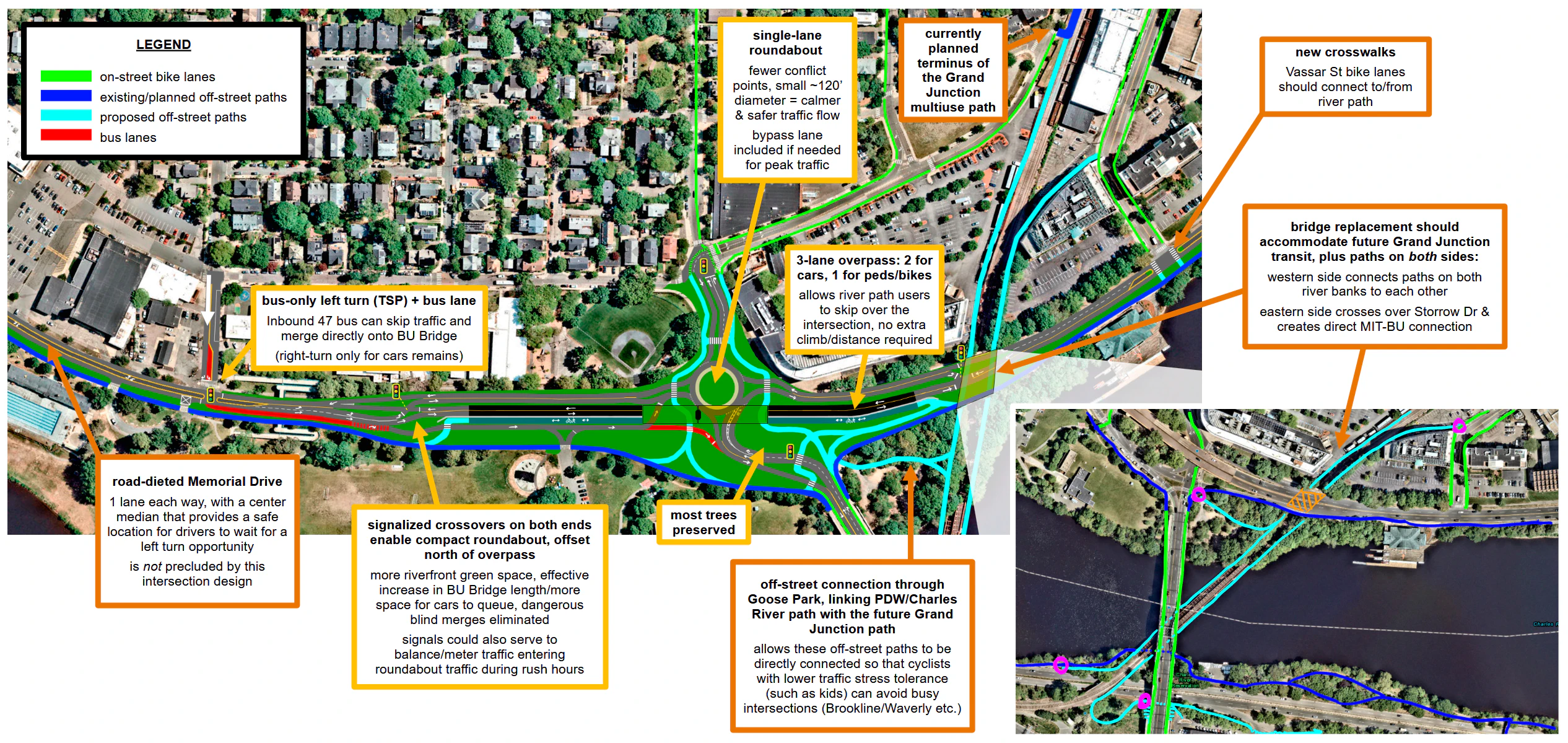
Why a single-lane roundabout?
The #1 priority should be making it safer and more accessible for pedestrians and cyclists to travel along or get to/from the river paths - something that has been long overlooked/neglected here.
Obviously, people will have to cross some kind of intersection here no matter what. So the question is, what form should that intersection take to maximize safety? The answer: a single-lane roundabout.
It’s important to note that a roundabout is different from a rotary, and the latter is definitely not what’s being suggested here. Local examples of rotaries include the one that exists under the Reid Overpass today, the Salem St rotary by Medford Square, or the one where the Arborway crosses Centre St. On the other hand, roundabouts are several times smaller, and as a result have much slower and safer traffic flow, as the below graphic from MassDOT illustrates:
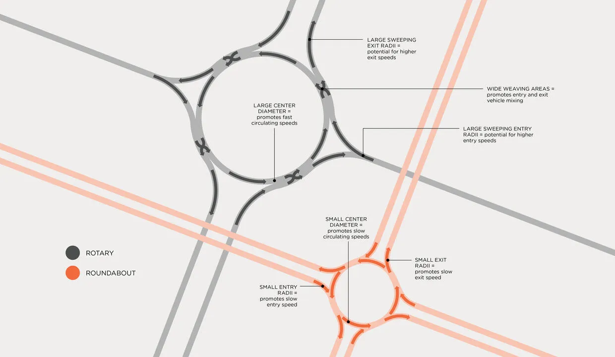
Studies have repeatedly shown that properly designed roundabouts are significantly safer than conventional signalized intersections, with conversions from the latter to the former resulting in large reductions in crashes, particularly injury crashes. MassDOT’s own roundabouts page states:
Converting an intersection with traffic signals to a roundabout can reduce property-damage-only crashes by 48% and fatal and injury crashes by 78%.
This also implies that a conversion in the opposite direction, a.k.a. turning a roundabout into a signalized intersection, would likely cause an increase in crashes. Given that 3 out the 4 options from MassDOT propose this exact type of conversion, this is concerning.
Below are some of the reasons roundabouts are safer.
Fewer potential conflicts, improved clarity
Roundabouts inherently have fewer possible conflict points. The below diagram illustrates all potential vehicle/vehicle conflicts:
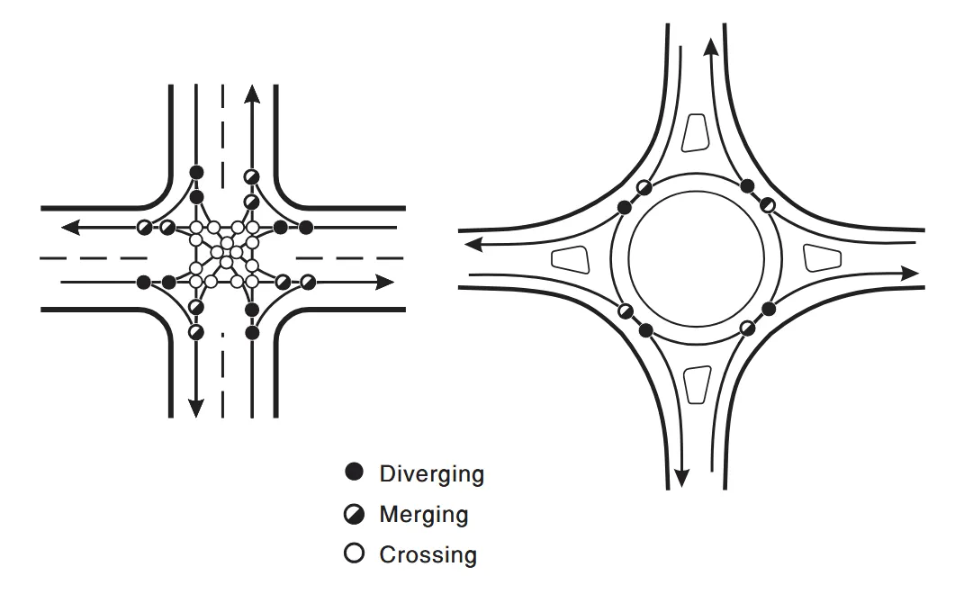
Per the FHWA: “A four-leg single-lane roundabout has 75% fewer vehicle conflict points—compared to a conventional intersection.” And in particular, crossing conflicts (the most severe category, more likely to result in injury or fatality) are completely eliminated.
This reduction in conflicts applies to pedestrians and cyclists crossing as well: they only need to cross 1 lane at a time, worrying about only 1 well-defined vehicular movement at a time. Compare this to a signalized intersection, where you’d need to cross 3 lanes at the absolute minimum (a minimum that all of MassDOT’s proposals exceed) and worry about cars coming from multiple different directions. For example, see this video and this video showing what path users have to deal with just a half-mile down the road from the project area, at Western Ave. Much of the crossing signal phase is spent waiting for thru or left-turning vehicles either blocking the box or running the red to get clear. Then once they can finally start crossing, path users need to deal with right-turning drivers trying to muscle their way through the crossing even though path users have the legal right of way. There’s just way too many potential conflicts to watch out for.17
A single-lane roundabout also solves the disorganization that is one of the main reasons the current multi-lane rotary is unsafe to cross. Careful placement of crosswalks relative to entry/exit points clarifies driver movements and makes vehicle flow clear and legible to all users. This in turn makes it easier for cyclists and pedestrians to predict when it’s safe to cross, instead of the Russian roulette/guessing game that exists today.
Built-in traffic calming
It’s physically impossible to speed straight through a roundabout (even more so if the center island is full of trees), whereas a signalized intersection still allows straight-line speeding (especially during off-peak hours) and is not immune to red-light running.
The speed mitigation can get even more fine-tuned than that: the design speed of a roundabout can be set to precisely fall within a safe range by reducing + narrowing the travel lanes and setting the curvature and cross-slope appropriately.
And for anyone worried that the curve is too tight: in the above sketch, the outer diameter (“inscribed circle” diameter) of the roundabout is ~120 feet, meaning it’s still easily navigable for MBTA buses which have a minimum turn radius of 44 feet. Honestly, the circle could be even smaller: MassDOT’s own Guidelines for the Planning and Design of Roundabouts document lists single-lane roundabouts as having inscribed circle diameters of 90 to 150 feet, and working with entry speeds in the 20-25 mph range (compatible with the 25 mph speed limit that DCR has agreed to here).
To accommodate the rare large truck18, a truck apron can be included around the center island; however, we really shouldn’t be encouraging more large truck traffic through here given that:
- the northbound intersection exit goes straight into a dense residential neighborhood of Cambridge
- the entirety of Memorial Drive has truck restrictions
- the pedestrian bridge at Magazine St, right at the western edge of the project area, has a <12’ clearance
- the next underpass going east has a 9’ clearance
- there have been numerous pedestrian/cyclist fatalities in the Cambridge/Boston area involving trucks
- the state does not have the ability to mandate widespread truck safety measures19
MassDOT should clearly state what their design/control vehicles are and justify their choice for anything larger than an MBTA bus.
In addition to the speed of circulation in the roundabout, the entry/exit speeds can also be controlled via the geometry, setting them to a safe level that can also ensure high rates of yielding to pedestrians and cyclists. The FHWA guide recommends a maximum entry design speed of 20 mph for an urban single-lane roundabout.
Improved efficiency
The really cool thing is that these safety improvements don’t come at the expense of congestion. There are many case studies of converting conventional intersections to roundabouts which led to large reductions in vehicle delay.
This might seem counterintuitive at first, but makes sense when you consider that signalized intersections fundamentally require one of the roads to be fully stopped in order for the other road to flow. And that stopped road will have cars piling up during the red, which need to be stored somewhere - leading to intersection designs that are padded with extra lanes to accommodate peak hour traffic, which then sit mostly wide and empty the rest of the time. This is an extremely poor use of valuable riverfront space in a dense urban environment, and also encourages dangerous speeding outside of peak hours.
Meanwhile, the flow of traffic in a roundabout, while it may be a bit slower, is continuous and steady, and so ends up moving more people through in the long run. It’s a win-win.
But what about traffic capacity?
So yes, a single-lane roundabout would be a big upgrade for safety. But there’s a problem: by itself, it cannot handle the (roughly) estimated20 ~45-50k+ vehicles that pass through this intersection every day. As the roundabouts guide from MassDOT linked above notes, a single-lane roundabout can handle daily service volumes of up to ~25k.
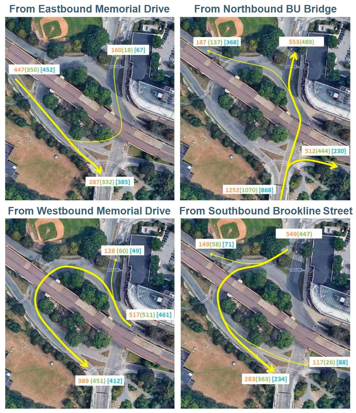
Overpass (+ potentially a bypass lane) makes it possible
Some might suggest that the solution is to switch to a multi-lane roundabout, but as mentioned previously (when discussing MassDOT’s option B2), this would be highly unsafe for the large numbers of people using the crosswalks here due to the risk of double-threat crashes. So instead of increasing the rotary size, an alternative option is to route some of the traffic outside of the rotary:
- have a road-dieted overpass carrying 2 lanes of Memorial Drive thru traffic, plus a ped/bike lane that allows river path users to skip over the intersection entirely
- could also add a bypass lane for right turns from BU Bridge NB onto Mem Drive EB, which is the heaviest turn movement (at certain hours, hundreds of vehicles, nearly ~40% of the cars coming off the bridge, turn right)
By separating the ~20k vehicles/day of Memorial Drive thru traffic onto an overpass, and potentially also diverting ~4k-6k vehicles/day into a BU Bridge SB > Mem Drive EB bypass lane (very rough estimate), traffic volumes for the main intersection fall into the ~20k-25k vehicles/day range. As per the below planning graph from the NCHRP’s 2023 Guide for Roundabouts, this falls within the feasible operating range for a single-lane roundabout. Of course, a more detailed traffic analysis would be needed, using more recent count data (data which MassDOT can hopefully share with the public, for full transparency), but this is promising.
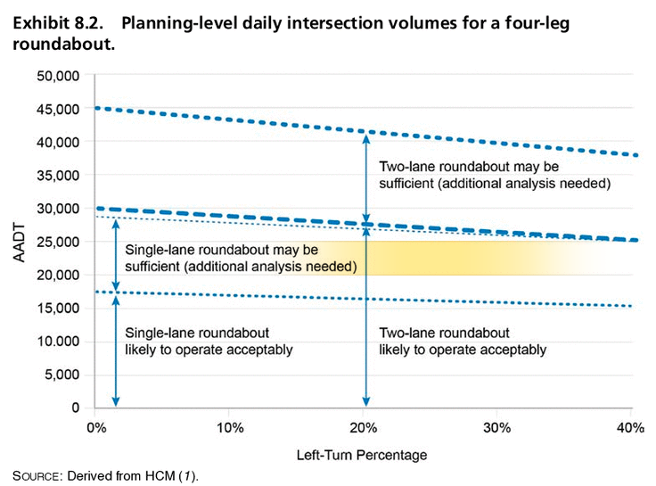
Note: while the alternative proposal drawing does include a bypass lane for now, there’s a chance more detailed analysis will determine it’s not necessary. Again, these traffic counts are old, leading to rough approximations, and the lower end of the range would still fall under the 1-lane roundabout threshold even without a bypass lane. In addition, a big chunk of traffic is taking the BU Bridge SB exit, directly upstream of the BU Bridge NB entrance, creating large gaps for those cars to enter the roundabout without a long wait, no bypass needed.
Let’s look at the worst-case scenario, the AM peak hour data shown in the above rotary traffic counts. The data is displayed again below, also noting total exit flows for each leg as well as circulatory flows (the sum of the vehicles from different movements passing in front of the adjacent upstream splitter island, calculated using the formulas from the FHWA’s guide).
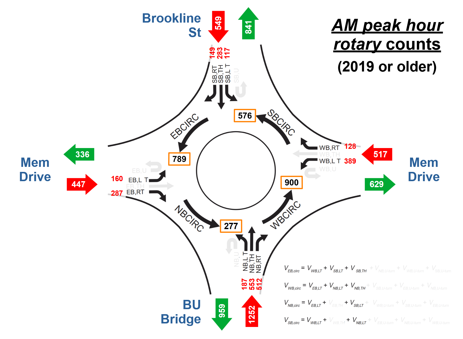
Of the 1513 cars entering the roundabout from the other 3 entrances besides the BU Bridge, 959 are exiting onto the BU Bridge, and only 277 pass through the southeast quadrant of the rotary. 277 cars amounts to only 4-5 cars per minute. That leaves enough space for the 20-21 cars per minute coming off the BU Bridge to get in there (1252 total cars coming from BU Bridge NB in the peak hour).
The FHWA guide also gives the following values regarding the operational limits of a single-lane roundabout between 80 to 180 ft in diameter, which can serve as additional quick checks that one here could work with the above AM peak hour/worst-case scenario counts:
The flow rate downstream of the merge point (between the entry and the next exit) should not be allowed to exceed 1,800 veh/h.
- Basically, if there’s too many cars already circulating in the rotary at a given point, cars at the entrances have fewer chances to get in so entry flow is reduced.
- From the above diagram (combining each entry flow with its conflicting circulating flow), the highest such flow is 1,529 vehicles/hour, immediately after the BU Bridge NB cars merge in. This is below the threshold (85%).
- If that’s too close for comfort for MassDOT, add in a bypass lane diverting the 512 vehicles/hour right-turn from BU Bridge NB > Mem Drive EB. The new highest flow point instead is immediately after the Mem Drive WB cars merge in: 1,417 vehicles/hour (79%).
Exit flows exceeding 1,200 veh/h may indicate the need for a double-lane exit.
- The largest exit flow is to BU Bridge SB, at 959 vehicles/hour.
- This also is below the threshold (80%).
Of course these are general guidelines, and more detailed traffic analysis/simulations with the latest data (which again, MassDOT should publish) would be needed to be certain, but this design isn’t as “out there” as one might assume. The diversion of all “straight”/thru movements to an overpass + a big chunk of the entering vehicles making right turns/exiting immediately rather than circulating makes a big difference.
In other words, a single-lane roundabout with 1 bypass lane seems highly feasible from a traffic standpoint. And there’s actually a good chance it’s still possible without that bypass, too. Honestly, even if further analysis/simulations give borderline results regarding the need for the bypass, excluding it would be preferable: the above looks at the worst-case scenario peak hour counts, but overbuilding an intersection to accommodate a condition that lasts for just 1 hour out of 24 is both inefficient and outdated. Even more so when it comes at the cost of safety.
As for the overpass, there will probably be 2 main objections from 2 very different directions:
- That 2 lanes is insufficient - MassDOT seems to believe this, given that they are pushing 4-lane designs for all 3 of their overpass proposals
- That overpasses = highway infrastructure and that the one here should be removed entirely, with a 100% at-grade replacement
Below are some thoughts on the first point, and the second point will be discussed later.
2 MV overpass lanes is plenty
A 2-lane overpass, with one MV lane each way, would be more than sufficient for the ~20k vehicles/day that use the Reid Overpass. 20k is the traffic volume given during the 2019 DCR meeting, see below image).
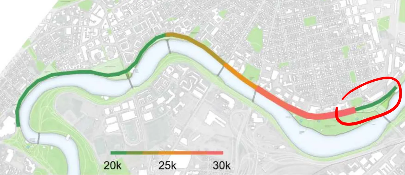
As several people pointed out during the January public hearing, we had a real-life demonstration of this in Fall 2024: the overpass was temporarily road-dieted with traffic cones in order to accommodate construction work on the short-term safety improvements around the rotary, and it was fine.
And currently, sections of Mem Drive immediately east of the overpass are temporarily being reduced to one lane each way due to construction work installing duct banks for the Eversource GCEP project, for a transmission line that will run under Memorial Drive from Ames St all the way to Magazine Beach - and that’s been fine too.
Quantitative data also supports a 2-lane overpass: the next bridge downriver, where Mass Ave crosses the Charles, has carried more than 20k/day vehicles just fine despite being reduced from 4 to 2 lanes in 2021. Boston regularly conducts traffic counts here, and in the ~4 years since the lane reduction, the bridge has averaged ~21.7k motor vehicles/day, with a peak of ~23.6k.
In light of all this, there is zero justification for a 4-lane overpass. The project team needs to explain to the public why they are proposing 4 lanes for all 3 bridge options they plan to advance.
Combining the overpass and roundabout strategically, with a shift + crossovers
While we could just replicate today’s layout and have the roundabout centered under the overpass, so that the overpass is sandwiched between on/off ramps for Mem Drive, those ramps would be nearly tangent with the roundabout, resulting in shallow entry/exit curves that correspond to higher speeds. This could be mitigated by stretching the roundabout to be much bigger that it otherwise needs to be, but this makes it less safe and space-efficient. In addition, having the overpass in the middle could obstruct several important sightlines, further reducing safety.
Instead, we can shift the roundabout to be centered north of the overpass, using traffic signals at the ends of the overpass to facilitate the necessary lane crossovers. This signalized crossover is functionally similar to the PDLTs in MassDOT’s alternative A3, but has a steeper crossover angle and also avoids sandwiching the 1 crossover lane between 3 going in the opposite direction, making it safer and much less likely to result in wrong-way driving (a significant issue with A3, as discussed above). Given MassDOT considers that design feasible enough to be worth further investigation, the crossovers proposed here should certainly be acceptable as well.
This shift would have several benefits:
- It enables the overall design to be more compact, freeing up more green space (~40% reduction in roadway area compared to today) - and in particular, a lot of that reclaimed space is actually contiguous with the riverfront rather than being scattered across a bunch of traffic islands like in MassDOT’s proposals
- As a whole, the roadways (as well as vehicle queues) are moved further away from the riverfront path, for a more park-like experience as well as reducing the likelihood of a crash like the one that killed John Corcoran
- The dangerous blind high-speed merge between the EB overpass lane and the Mem Drive EB on-ramp gets eliminated entirely, replaced with a fully signalized lane crossover
- Extends the effective “length” of the BU Bridge, adding ~300+ ft to the short 1000 ft current length, which provides more space for vehicles to queue in an orderly manner instead of overflowing into the intersections at either end
- That added length contains curves, which in combination with the shifting of the roundabout entrance to a flatter location, helps slow down vehicles coming fast off the BU Bridge before they enter the main intersection
- The signalized river path crossing at the foot of the BU Bridge is no longer immediately adjacent to the rotary/roundabout exit like it is today, reducing the impact of crossing path users on traffic circulation
The presence of the crossover signals can also slow down speeding Memorial Drive thru traffic using the overpass, introducing stop points rather than the uninterrupted flow that exists today. And these more complicated vehicle movements are done well away from where peds/bikes are crossing - again, keeping crossings short and simple, with path users only needing to worry about 1 traffic movement at a time.
Big bonus benefit: a ped/bike overpass for the river path
Investing in a ped/bike-only bridge, such as the Hovenring-inspired proposal linked above, is a tall order given the chicken-and-egg problem of poor existing infrastructure preventing user volumes from growing to levels that could be used to justify such an investment. But if the state is going to build an overpass for motor vehicles anyways, then allocating some width for pedestrians/cyclists suddenly becomes low-hanging fruit. For example, take a look at where the East Bay Bike Path in Providence, RI crosses the Seekonk River - when the I-195 bridge was replaced, a slice of the old historic bridge was converted to a linear park, with a separate pedestrian walkway and 2-way bikeway. And actually, MassDOT is already doing this for the currently under-construction Bowker Overpass replacement project: the new 2nd bridge over the Pike (with a span at least 200 ft long) that connects Boylston St/Charlesgate to Comm Ave will also have a sidewalk, shared-use path, and a dedicated bikeway.
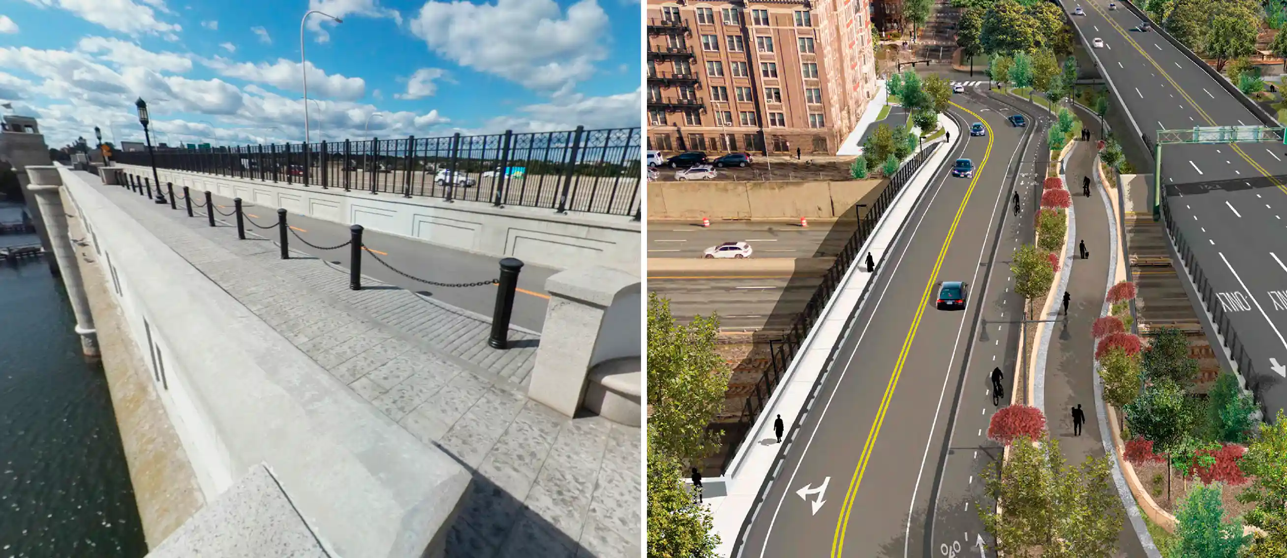
A ped/bike lane on the Reid Overpass would give the hundreds of river path users going east-west a way to avoid conflicts with cars entirely, bringing the river path closer to the ideal of an off-street path, where interaction with motor vehicle traffic is minimal.
This happens to benefit drivers too, because this means the crosswalk at the foot of the BU Bridge - currently the other main traffic bottleneck after the Comm Ave signals - will get activated much less frequently than it does today, since the overpass would be the preferred option for most pedestrians/cyclists (no waiting for the crossing signal, no conflicts with cars, and nice views from up high). This means fewer delays for people driving onto/off the BU Bridge.
Handling rush hour traffic: metering
One potential issue with roundabouts is that when there’s a lot of “left-turning” cars (a.k.a. going 3/4 of the way around the circle), there’s very few gaps in traffic for cars at the “downstream” roundabout entrances to enter the circle, and those entrances subsequently can get backed up. Here is a nice short video illustrating this.
However, the aforementioned crossover signals can mitigate this, by serving a dual function of indirectly metering roundabout traffic (only as necessary, during peak traffic). This can help manage queues and ensure that drivers from all 3 traffic streams headed towards the BU Bridge SB lane have an equally “fair” wait time to their destination.
There aren’t a lot of examples of roundabout metering in the U.S., especially since modern roundabouts themselves are still relatively uncommon here. However, roundabout metering is certainly doable. Here is a video from the Washington State DOT (WSDOT) showing roundabout metering in action, and their presentation in this 2019 TRB webinar indicates it successfully achieved the goal of reducing the queue on the critical approach. The webinar also included 2 additional roundabout metering case studies from Indiana and Florida. If these other states can figure it out, Massachusetts can too!
In addition, such a setup would likely be more balanced/“fair” than MassDOT’s designs. In their options with slip lanes for cars coming from Memorial Drive EB and turning right onto the BU Bridge, those cars basically get priority over the other signalized movements headed for that southbound lane. Yes, technically the slip lane cars are supposed to be the ones yielding, but what will actually happen is they will fill up the southbound lane to capacity, subsequently forcing cars coming from other directions to block the box when it’s their green signal. This definitely applies to designs A3 and B3, possibly B1 also21. The same goes for the 2-lane roundabout option of B2 (which again, replicates the existing rotary) as the shallow entrance for Mem Drive EB cars means that even though they’re supposed to yield to cars already in the circle, they just need to hug the curb and inch forward, making it so that it’s the circulating cars that are forced to merge in.
Additional feature: Granite St changes could solve Cambridgeport gridlock
Reversing the direction of Granite St would provide an outlet for the neighborhood that is independent from the rotary and doesn’t come to a standstill during rush hour. Cars would instead exit Granite St at Magazine St, which is a 2-way street. Note: this suggestion is not a new one, and has been brought up by others in past meetings related to this intersection.
This reversal would reduce the usage of the Magazine St > Granite St and Pearl St > Granite St routes by cut-through drivers, better separating local vs. regional traffic. It could also have the additional benefit of reducing box blocking at the Waverly St/Brookline St intersection, which sometimes impedes northbound traffic going from the rotary to Brookline St. By eliminating the “competing” stream of right turns exiting Granite St, drivers coming off Waverly St have much less of an incentive to engage in box-blocking behavior.
The tradeoffs of reversing Granite St would be:
- Neighborhood residents who are trying to access Mem Drive EB or the BU Bridge would need to take a longer route - for example, using the Pleasant St signal to make the necessary left onto Mem Drive, looping around until Sidney St, or taking neighborhood streets to Mass Ave.
- The existing curbside school bus loading zones would need to be moved, either to the opposite side of Granite St which would mean more students needing to cross the street, and/or to Magazine St which would retain direct curbside boarding but is further from the main entrance.
If that’s too much of a tradeoff, an alternative is to only reverse the section west of Pearl St — in other words, make it so that cars exiting Pearl St on to Granite St can turn either left or right22. This retains direct curbside school bus boarding for the Morse, albeit shifted east of Pearl. It also retains more convenient neighborhood access to the rotary during off-peak hours, though this would also mean that Pearl St remains an attractive option for cut-through drivers, and cars could still back up onto Pearl St on particularly severe traffic days.
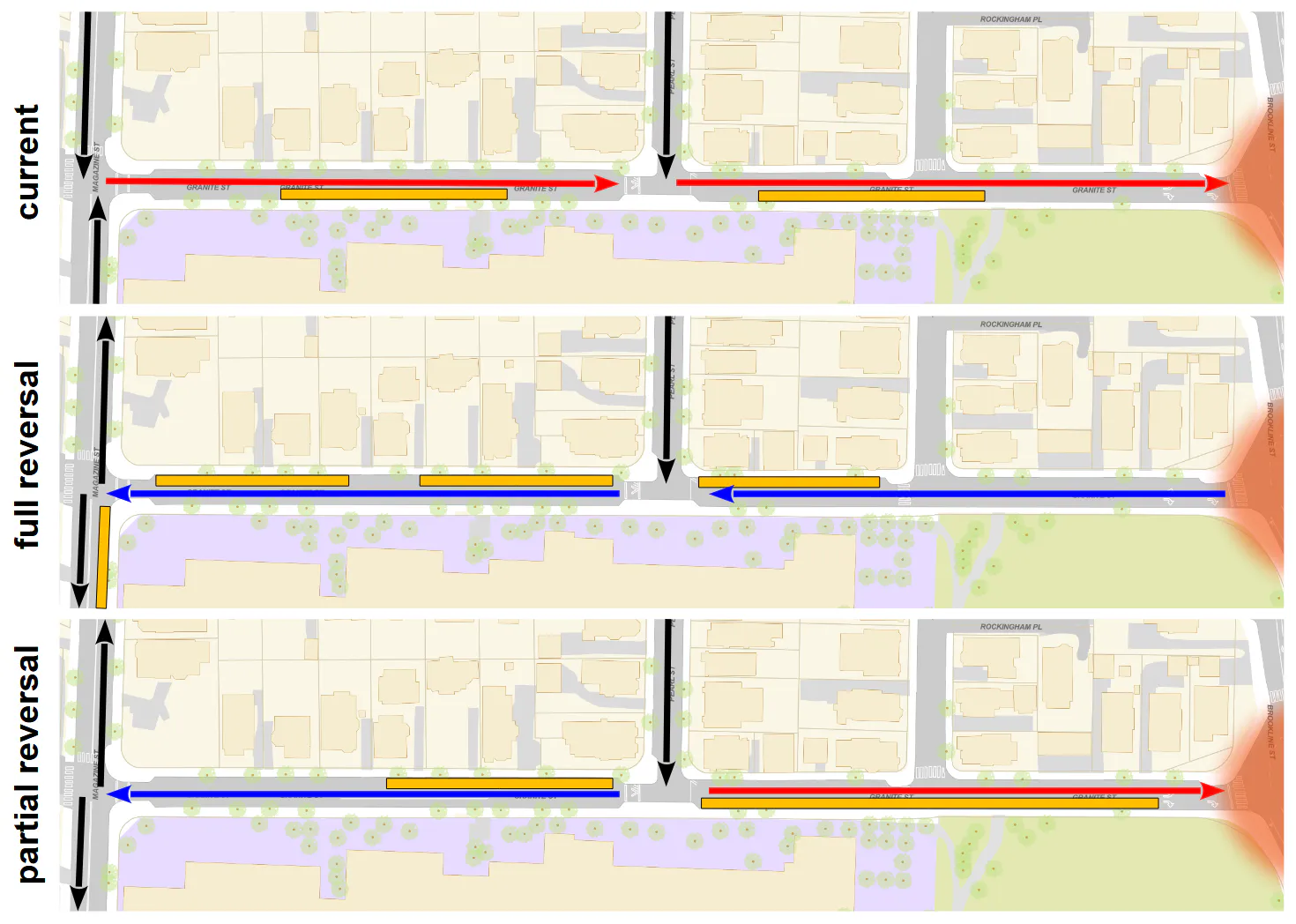
Granite St is Cambridge’s jurisdiction and technically not in the project area, however:
- This directly impacts the main intersection.
- MassDOT should be collaborating closely with Cambridge regardless.
- Cambridge would likely be willing to implement something like this if it had neighborhood support and if the state made the necessary changes on Mem Drive to help facilitate it.
Of course, any changes should be made only after discussion with the impacted neighborhood residents and the Morse School community, who are most familiar with the actual conditions on the ground. These conversations could also touch upon other opportunities to better handle regional traffic filtering through Cambridgeport. For example, Sidney St > Waverly St is currently a major route for drivers who want to cross over the BU Bridge into Boston. See the below map: while most of Sidney St is lined by lab/office buildings, the southern end is more residential, and rotary backups can extend up to these residences. Making Waverly St fully 2-way23, then reversing the Sidney St south of Erie St (even just 1 block), could reroute cut-through traffic away from residential areas. This is a very preliminary idea, and possibly beyond the scope of this project, but is another example of how there are solutions for mitigating traffic impacts beyond pursuing the dead end of increasing throughput.
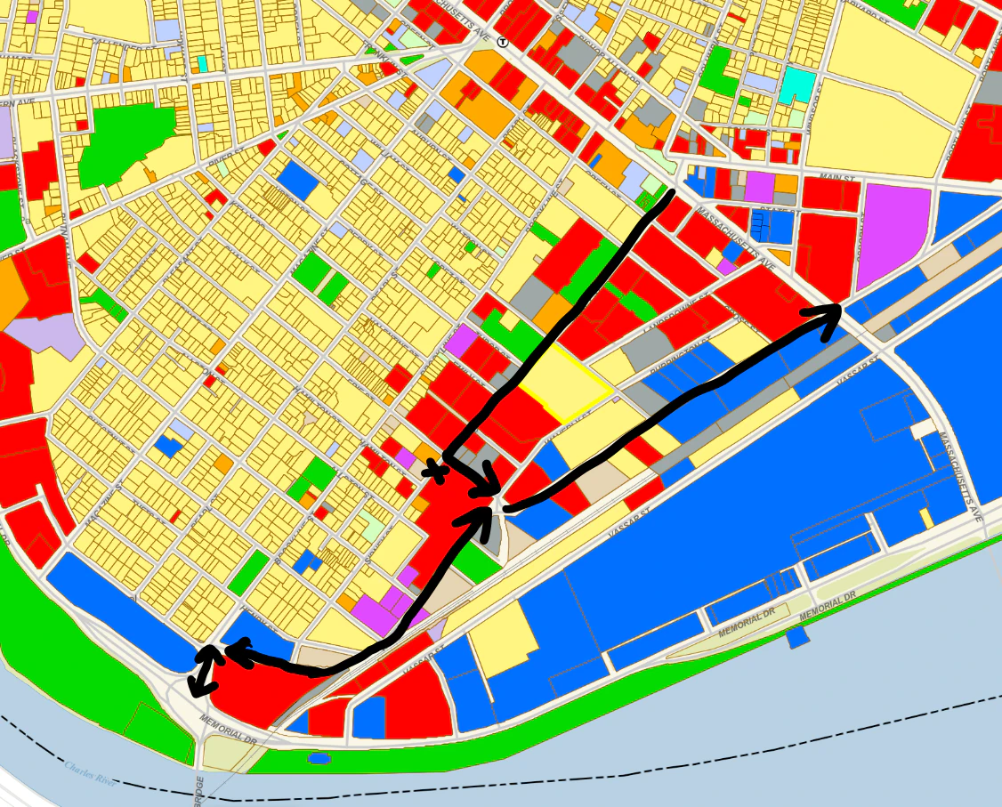
There will probably be differing opinions given different priorities placed on school dropoff/pickup operations vs. direct Memorial Drive access vs. street parking, but hopefully everyone can agree that the status quo — which MassDOT’s designs perpetuate — is untenable.
Additional feature: bus priority
As for transit, the Granite St reversal proposed above would also help buses like the soon-to-be high-frequency 47 bus24 bypass traffic in the main intersection, ensuring more frequent and reliable service for Cambridgeport’s main transit option. Instead of making a right turn from Pearl St on Granite St, the inbound 47 can instead turn left, continue onto Magazine St, then take advantage of transit signal priority for a bus-only left turn from Magazine St onto Memorial Drive25. This allows the bus to access a dedicated lane on the other side of the overpass that merges directly onto the southbound lane of the BU Bridge. Other buses such as shuttles could use this too.
An alternative option, previously drawn up by other advocates as part of a past proposal for quick-build rotary improvements, is to have a bus lane on Granite St, continuing onto a bus lane going around the roundabout itself. However, such a bus lane would definitely be abused by certain drivers to cut in line, because it would be impossible to enforce. The bus lane being immediately adjacent to the regular vehicular travel lane, with no separation between them for the entire length, makes it too easy and tempting for drivers to cut in if the main lane is backed up. Even if a barrier was built, it would have multiple entry points. These line-cutting drivers assume (usually correctly, unfortunately) that they will get away with it. This is super frustrating for the drivers who do follow the rules; in addition, if enough drivers do this, the bus lane will fail to work as intended.
While the MBTA will soon begin rolling out automated camera enforcement on its buses after the relevant state legislation was signed into law in January 2025, they can only issue tickets for stopping or standing in a bus stop or lane. Moving violations still can only be issued by police.
Having significant physical separation (in the form of the overpass itself) between the bus lane and the regular traffic lanes, as proposed in this alternative design, makes this kind of misbehavior much less likely to happen. And it makes it possible to install single-point access control if necessary, e.g. something like these gates that exist at certain MBTA busways.
Other notes
Again, the above is a rough concept sketch and many aspects of it can be tweaked to meet different goals. Below are some additional considerations.
Bypass lane
The sketch includes a bypass lane/slip lane for BU Bridge > Mem Drive right-turning cars, for now. But as previously discussed, it would be safer and potentially feasible to leave that out. In which case, there’s the question of how you handle the 2 NB lanes on the BU Bridge and have them merge without backups. The ideal would be reducing the BU Bridge to 2 MV lanes, and replacing that with a bus lane. This is extremely unlikely to happen, though - there were even some public commenters who wanted the opposite, asking for the BU Bridge to be changed back to 4 MV lanes by removing either a sidewalk or the bike lanes to make that fit.
Dodging trees
Another nice thing about fewer lanes and reduced footprint is there’s a lot more flexibility in the design. The exact placement of the roundabout and the routing of the entry/exit lanes can be easily shifted to preserve as many of the existing trees in the current rotary as possible, particularly mature ones.
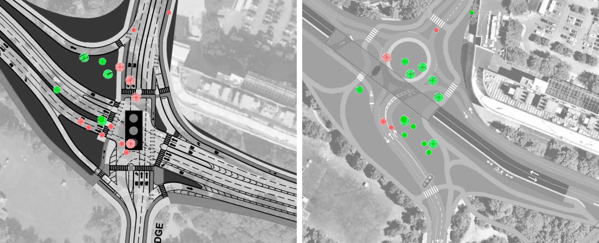
The roundabout could be made even smaller in case that enables preserving additional trees. The above drawing shows a ~120 ft diameter roundabout, but that could go down to ~100 ft and still work for MBTA buses.
Overpass span length
From the presentation, it seems like MassDOT has a preference for shorter bridge spans: for both option B1 (a 150’ span) and B3 (a 120’ span), MassDOT lists “shorter/smaller bridge reduces cost and visual impact” as one of the main benefits.
The claim of reduced visual impact is debatable — the solid wall of an abutment seems like it would be more of a visual obstruction than a bridge span, which you can at least see under/through to the other side. Maybe if there was a planted slope it would look nicer, but in most cases the ground-level roadway is immediately adjacent to the abutment for space reasons, and would therefore require a vertical wall of concrete (though it could be cladded with brick for appearances). Here is an example from Somerville of what such a wall would look like:
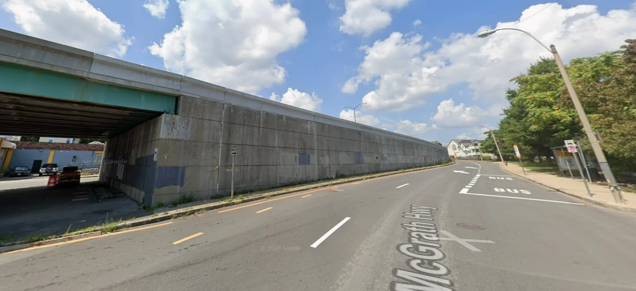
As for cost, it also seems that constructing a taller/longer bridge abutment would be more expensive and require more construction disruption than a longer bridge with piers, though it’s possible long-term maintenance costs could tip that balance.
That being said, the alternative proposal sketch does also include a shorter span with longer abutments, just in case that really is an important consideration for MassDOT. The 2-span bridge is ~270 ft as drawn, but could easily be shortened: if you cut down one additional tree, the shared use path could be routed much closer to the roadway, allowing the eastern span to be shortened and putting it on par with the 2x120 ft bridge in MassDOT’s option B2. Or to go even further, you could remove the exit lane under the overpass for the Magazine Beach parking lot, reconfiguring the design slightly so that cars leave the way they came in (as in the original MDA quick build concept), though this means slightly less parkland. And the shared use paths could tunnel through the bridge abutments. A combination of these changes could shrink the bridge to a single span on par with the 120-150 ft spans in options B1 and B3.
Why is Alternative C an exception to the “overpasses = bad” rule?
“No overpass” is probably the more popular option among advocates in this space. For example, StreetsblogMASS made its stance pretty clear:
One option would be to build another viaduct, in order to continue subsidizing high-speed car traffic along Cambridge’s riverfront. Another option under consideration would re-route traffic into a slower, safer at-grade intersection that could increase public greenspace along the Charles River.
And it’s definitely true that the overwhelming majority of overpasses are highway infrastructure, prioritizing motor vehicle throughput to the detriment of pedestrians and cyclists. In fact, there’s a perfect example of a “bad” overpass right at the western end of the project area by Magazine St: a pedestrian bridge, which turns what should be a quick 38 ft-long flat road crossing into a 655 ft-long diversion requiring a useless 13+ ft up-and-down, all because this originally recreational parkway has been allowed to degrade into a noisy, polluting, and dangerous highway that acts as a barrier between the city and its riverfront.
In cases like that, overpass elimination is a good thing - for example, the nearby “grounding McGrath” project will be a huge improvement26, replacing the viaduct walling off East Somerville from the rest of the city with an at-grade boulevard.
However, grade separation is not inherently good or bad, it very much depends on context. For example, it’s a good thing that the PDW river path goes under the Eliot Bridge via tunnels in the abutments - imagine what a nightmare crossing those intersections at-grade would be. And it would be great if that setup could be replicated downriver at the JFK Bridge. But on the other hand, it wouldn’t make sense for the river path to be elevated over the Western Ave intersection. It’s important to look at the why, rather than just the what, and to separate the symptoms from the root problem.
The terrain here means an overpass won’t actually place extra burden on pedestrians/cyclists
The biggest reason most pedestrian overpasses suck is that they add pointless distance and elevation to a walk, all so motor vehicle traffic below can speed along. Again, going back to the Magazine Beach overpass example:
- it demands a 13-foot climb to get high enough for there to be enough clearance for cars passing under the bridge
- then you need accessible ramps up to and down from that height at no steeper than a 1:20 slope
- this results in the crossing distance being increased by hundreds of feet, ending up seventeen times longer than an at-grade crosswalk
This is not merely an inconvenience, it can be a serious barrier to access for anyone with limited physical ability.
However, an east-west overpass by the BU Bridge would not have this problem, because the ground level here already has a significant elevation gain built in. This is due to the clearance needed over the Grand Junction train tracks: the existing bridge has a 16’2” vertical clearance, putting the ground elevation over the tracks at ~30 feet — see the below map showing LIDAR elevation data from MassGIS. This means that even today, path users coming from Magazine Beach (where ground elevation is ~10 feet) have to make a 20-foot climb regardless.
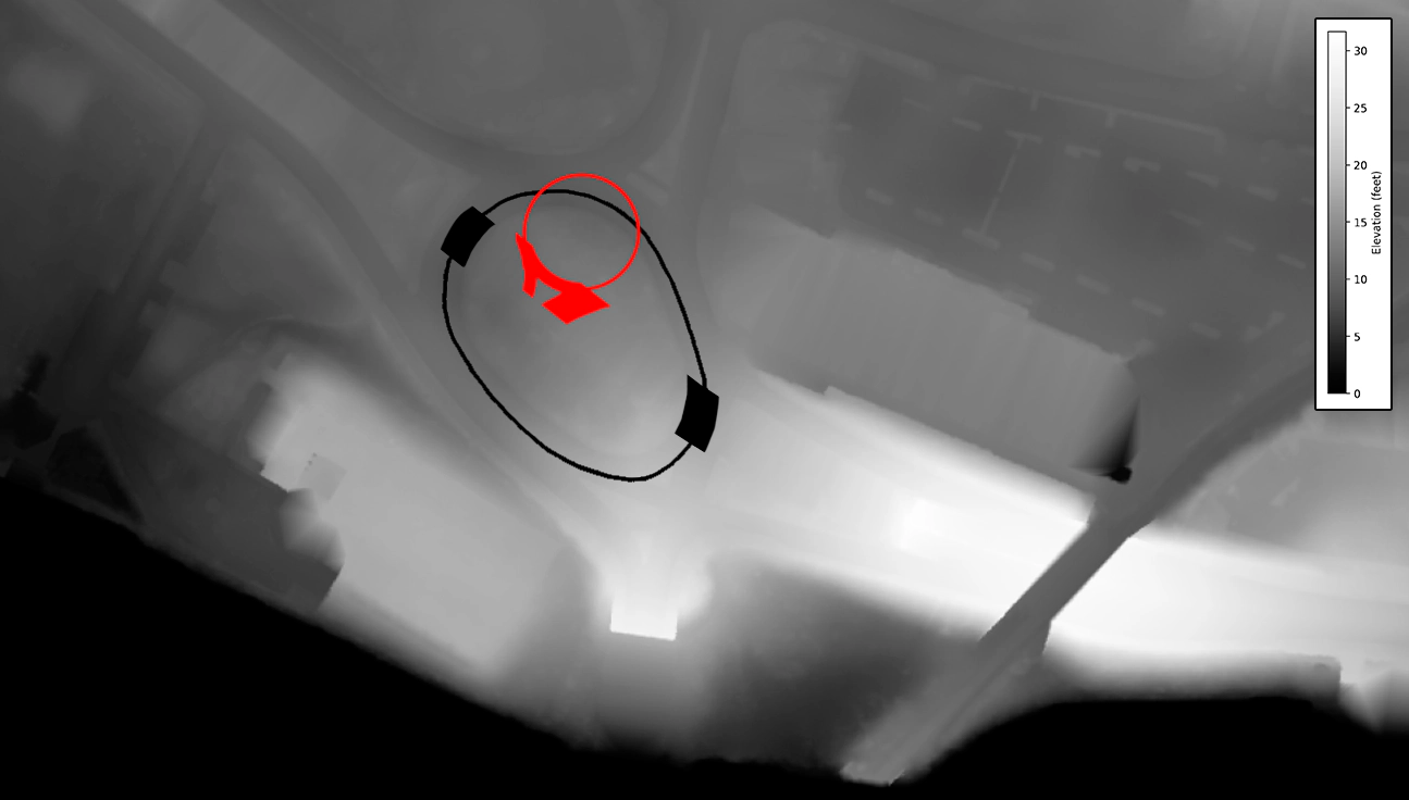
Now, it’s true that the currently existing overpass is higher - there’s clearly a downhill slope from the peak of the overpass down to where the Grand Junction tracks are:
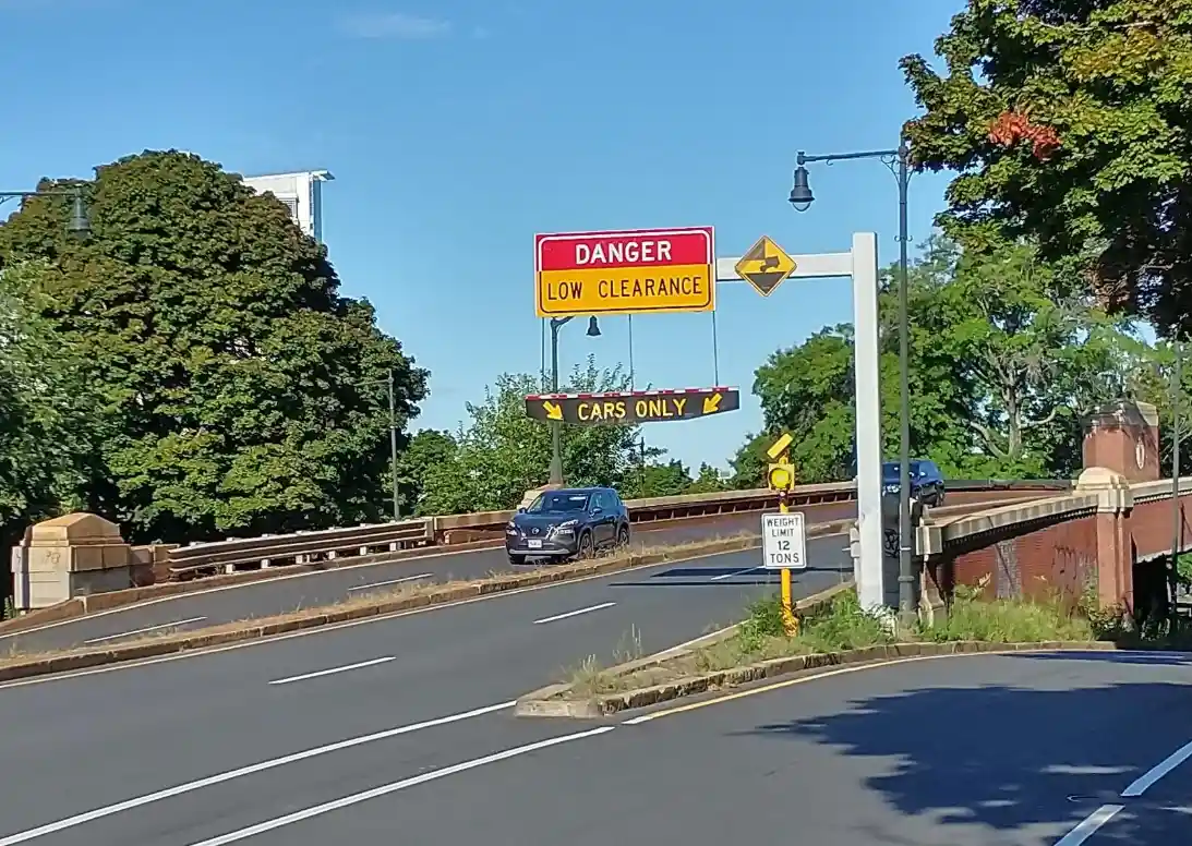
And if the overpass was rebuilt exactly as-is, and we then put the ped/bike path on it, then yes, it would be extra work for path users. But this excess height is due to the fact that the existing rotary is so large that the eastern end sits partway up the hill. That means that the ground elevation under that part of the overpass is already starting high, around 17-18 ft, so once you add the 14’5” vertical clearance for vehicles27 plus whatever the structural depth of the overpass is — maybe 4-5 feet? — the bridge deck ends up being around ~37 ft elevation. This is about 7 feet of additional climb for peds/bikes beyond the 30 ft ground high point by the Grand Junction track bridge.
But by shrinking the roundabout as well as shifting it northwest, to a part of the intersection that’s flatter28 and several feet lower (the section of roadway under the dieted overpass would be around 13-14 ft elevation29), then even stacking up the vehicle clearance + bridge structural depth puts the bridge deck around 33 ft elevation at most. That’s much closer to being on par with the 30 ft elevation by the Grand Junction track bridge. And if MassDOT does the smart thing and raises that bridge a few feet to future-proof for Grand Junction transit, as discussed previously, then the overpass would actually be the lower of the two.
In other words, an overpass here would merely shift the existing 20-foot climb westward, not create any new climbing.
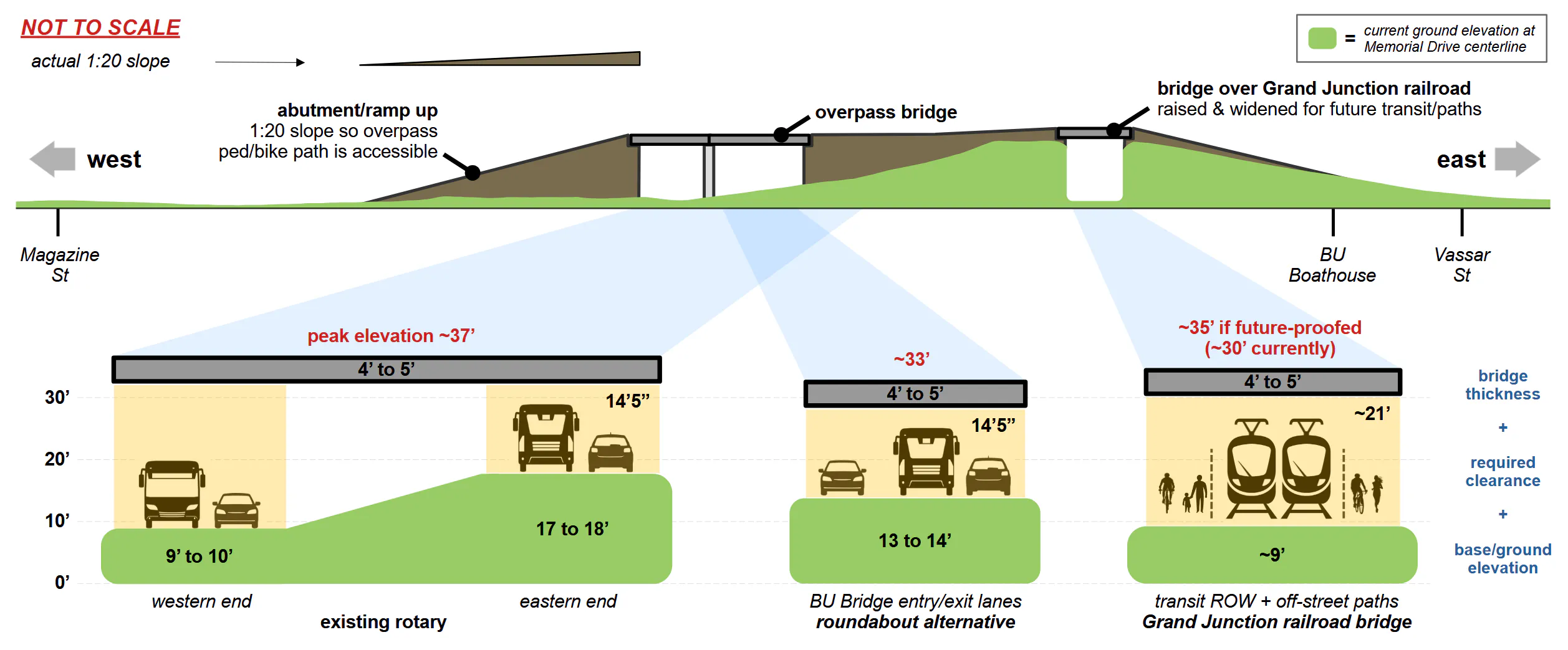
Finally, no path users will be forced to use the overpass - at-grade crossings in all directions will remain. This proposal includes a signalized east-west 3-lane crosswalk near the foot of the BU Bridge, similar to what exists today. However, the overpass will likely be the preferred option for most people traveling east-west on the path, since it lets people avoid all conflicts with cars and skip waiting for the crossing signal, and will also have nice views as the cherry on top. The main users of this crosswalk will be a relatively small subset of people:
- cyclists “turning left” from the WB river path to BU Bridge SB
- cyclists “turning left” from BU Bridge NB to the WB river path who don’t want to deal with the overpass/prefer a more direct route - though with the right path routing, cyclists can preserve their momentum coming downhill off the BU Bridge to reach the overpass quickly with very little effort and most of them would prefer that over waiting for the crosswalk signal
- a few stray pedestrians who walked across the BU Bridge and belatedly realized they actually meant to be on the other side
This would not preserve excess MV capacity
But what about the motor vehicle lanes on the overpass?
First, as discussed above, this proposal reduces the number of MV lanes on the overpass from 4 to 2. Note that 2 (or more) Memorial Drive thru-lanes will exist no matter what, even in a fully at-grade design. The ACTUAL choice here is whether or not those thru lanes are separated out. This isn’t the same as permanently “baking in” excess vehicle capacity. Having them elevated seems preferable, as it means significantly fewer cars (~20k/day) to conflict with the peds/bikes who must cross at grade.
In addition, this overpass does not preclude a road diet of Memorial Drive. In fact, the above concept sketch shows it working with a road-diet already in place, though it’s compatible either way.
The most compelling argument for overpass elimination here is that it would make future lane reductions easier. After all, it’s definitely easier/faster to remove ground-level lanes than it is to take down an overpass. But the absolute best possible signalized intersection after removing an overpass in a low-traffic future is 3x3 lanes - again, there will be 2 through lanes no matter what (1 in each direction), plus a turn lane, at minimum.
Meanwhile, the intersection in the above overpass + roundabout alternative is equivalent to 4x3 lanes, possibly 4x2 if traffic analysis and/or future VMT reduction allows that slip lane to be removed from the design. This is already pretty close to that theoretical 3x3 endgame.
More importantly, MassDOT will not be constructing a 3x3 at-grade intersection design anytime soon, which brings us to the next point:
The tradeoff is actually worse
It’s important to remember that the choice right now is not between an intersection with an overpass on top vs. that exact same intersection by itself. Rather, the overpass-free intersection will be significantly larger, because MassDOT absolutely will compensate for overpass removal by making up that 20k/day thru vehicle capacity at-grade30.
So yes, while removing the overpass and replacing it with a large ground-level signalized intersection/taking a “temporary” step backwards on riverfront access could be pitched as short term pain for long term gain, dealing with an awful 6-7 lane mess for the next couple of decades31 just because it theoretically allows for a 3x3 intersection in the far future does not seem worth it. Why not just build a 4x3 option (that is also way better for peds/bikes) from the get-go?
Of course, if MassDOT refuses to budge on dieting their 4-lane overpass plans, then the math changes and the at-grade options might start looking like the better option. But as discussed above, 4 lanes is truly indefensible.
The downsides, and mitigations
Every option has both pros and cons, and this one is no exception/no one is saying it’s perfect. However, the main concerns can be reasonably mitigated:
Risk of speeding on the overpass
There’s no denying that the currently existing overpass exacerbates speeding on the sections of Memorial Drive immediately next to it. However, the overpass in this proposal has some features that mitigate this so that at the very least, it’s on par with a 100% at-grade signalized alternative.
As previously mentioned, there would be signals upstream of the overpass on Mem Drive stopping overpass traffic, as this is necessary to facilitate lanes crossing over, so it would not actually be uninterrupted flow32 and on par with at grade options in this respect. Cars can blast straight through an intersection just as fast as or even faster than over a bridge, especially during off-peak hours.
However, the unavoidable uphill/downhill (though again, this problem is not unique to an overpass, at-grade options will still have the same amount of elevation change) can encourage speeding, so additional traffic calming measures should be introduced. Some potential options:
- Making the overpass lanes as narrow as possibly allowed (10 ft width)
- Visual narrowing as well - possibly flexible vertical delineators all along the centerline and/or an extra tall barrier (things like planters) separating the cars from the ped/bike lane
- Introducing curvature to sections of the overpass, though this would probably increase cost (not sure if curving the spans vs. the abutments would be more expensive)
Overpasses can be pretty ugly
While actual visual impacts related to safety (e.g. night-time visibility) can be addressed with good lighting, there’s certainly also aesthetic impacts. An overpass is a visual barrier and most have dim and grimy undersides. But the design already partly mitigates this by reducing the width of the overpass from 4 lanes to 3 (2 for cars, 1 for peds/bikes), and it can be further mitigated by good design.
A comparable local example of what this could feel like is one of the Storrow Dr flyovers by Charlesgate (street view), which passes right over/by the PDW river path. See below screenshots - measuring right over that support pillar in the foreground, the overpass is 34’ wide. The posted sign says vertical clearance is 11’.
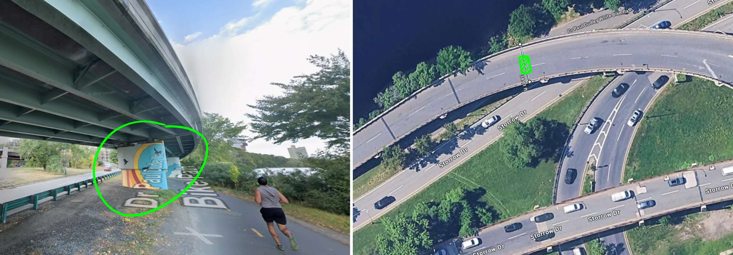
34’ is enough width for 3 lanes plus a safety barrier for the ped/bike lane. As for height, assuming we’re not allowed to reduce the current 14’5” vertical clearance of the Reid Overpass33, it would be slightly higher, letting in more light. This video shows what it looks like from the POV of someone biking under that viaduct during the winter - even on a snowy, overcast day, it’s not that bad. And in this case, paths are routed such that the time spent under the bridge would be just a few seconds at most.
Will it be as pretty as open parkland? Of course not. But it can be made to look nicer than the rusty metal and crumbling brickwork under the Reid Overpass today, and it’s certainly not worse than the wide paved intersections MassDOT is proposing. And the shadowed zone where you can’t plant trees is compensated by major gains in green space elsewhere.
It’s also possible to have the underside actually look nice, though that depends on MassDOT’s willingness to invest in that aspect. There’s lots of different potential directions to go with this:
- recreate the historic appearance of the Reid Overpass with brick
- design the bridge so that it blends into nature more - for example, the Appleton Footbridge has green Y-shaped support beams that mimic the surrounding trees
- lean into the utilitarian aesthetic - for example, the underside of the Zakim as seen from Paul Revere Park, or the underside of new Bill Russell Bridge as seen from the ped/bike underpass
And the underside appearance of the bridge can also be offset by adding an overlook that lets pedestrians and cyclists atop the overpass pause and enjoy the view, similar to the overlooks by the towers on the Longfellow bridge.
Final comparison across proposals
Below are some quick comparisons of the different designs.
First, here are some conflict point diagrams for the different intersection types. These are generic/textbook diagrams (from VDOT & FHWA) that generally assume 1 lane for each movement, and don’t account for the additional lanes and slight design variations in MassDOT’s proposals. In addition, these outline vehicle-vehicle conflicts only, and is just a baseline - some of these are way worse for pedestrians in ways unrelated to the raw # of conflict points.
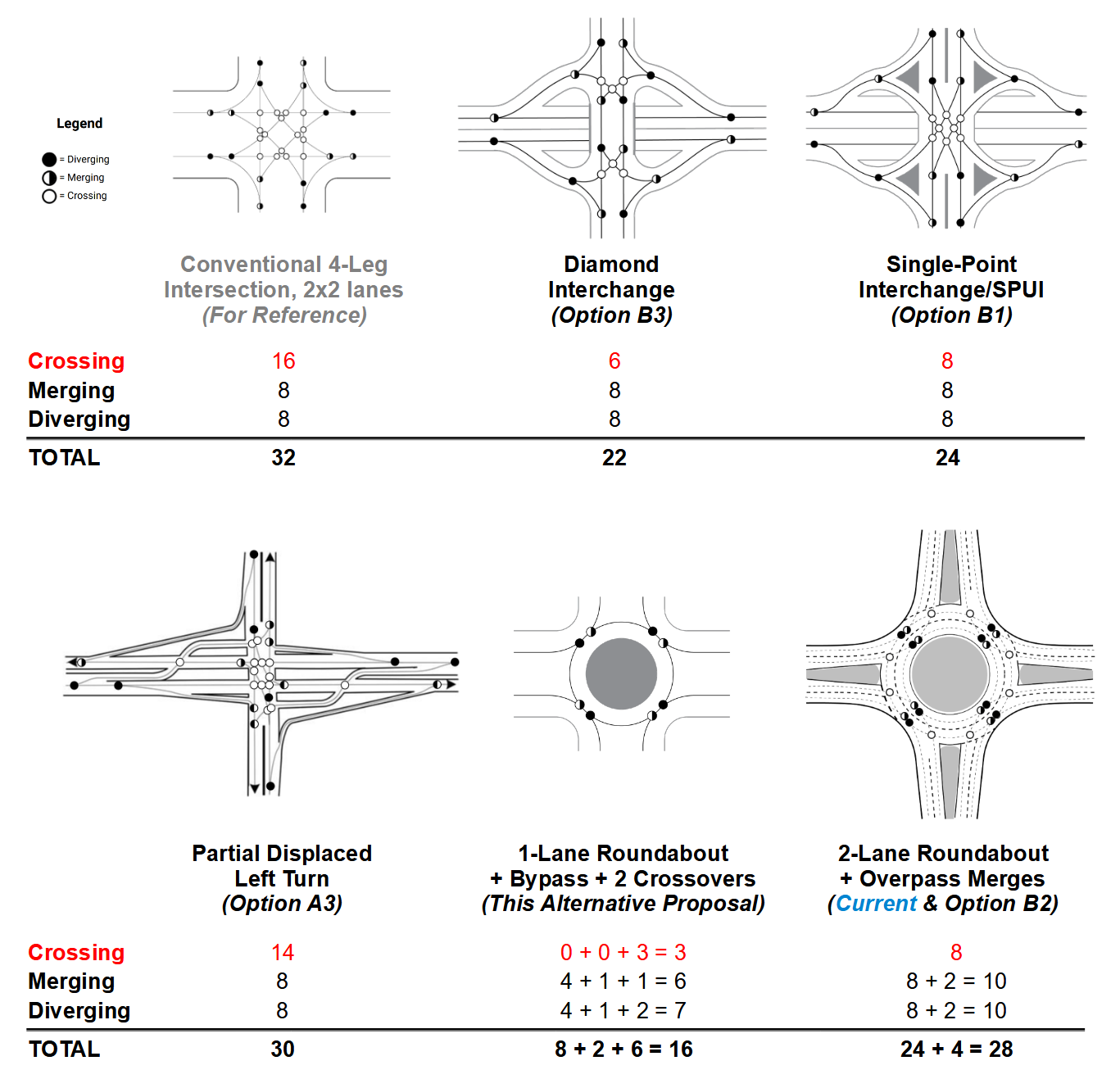
That being said, it’s still a useful exercise for getting a rough comparative idea of intersection complexity and the types of crashes that could occur, including which designs are more likely to have more serious crash types (a higher proportion of crossing conflicts). For example:
- Of all the design options, a PDLT (as in Option A3) has the most conflict points overall, and significantly more crossing conflicts.
- Meanwhile, the 1-lane roundabout alternative has both the fewest number of crossing conflicts, and way fewer overall conflicts compared to all the other options (nearly half of the PDLT)
Next is a visual comparison of the roadway area of the different proposals vs. the current condition, all zoomed/cropped onto the exact same area to enable direct comparison. Unfortunately some of the design screenshots in MassDOT’s presentation were cropped pretty narrowly, so the comparison area is not very big/only covers the portion immediately around the main intersection. Ideally, the full designs would be posted to enable comparison across the entire project area.
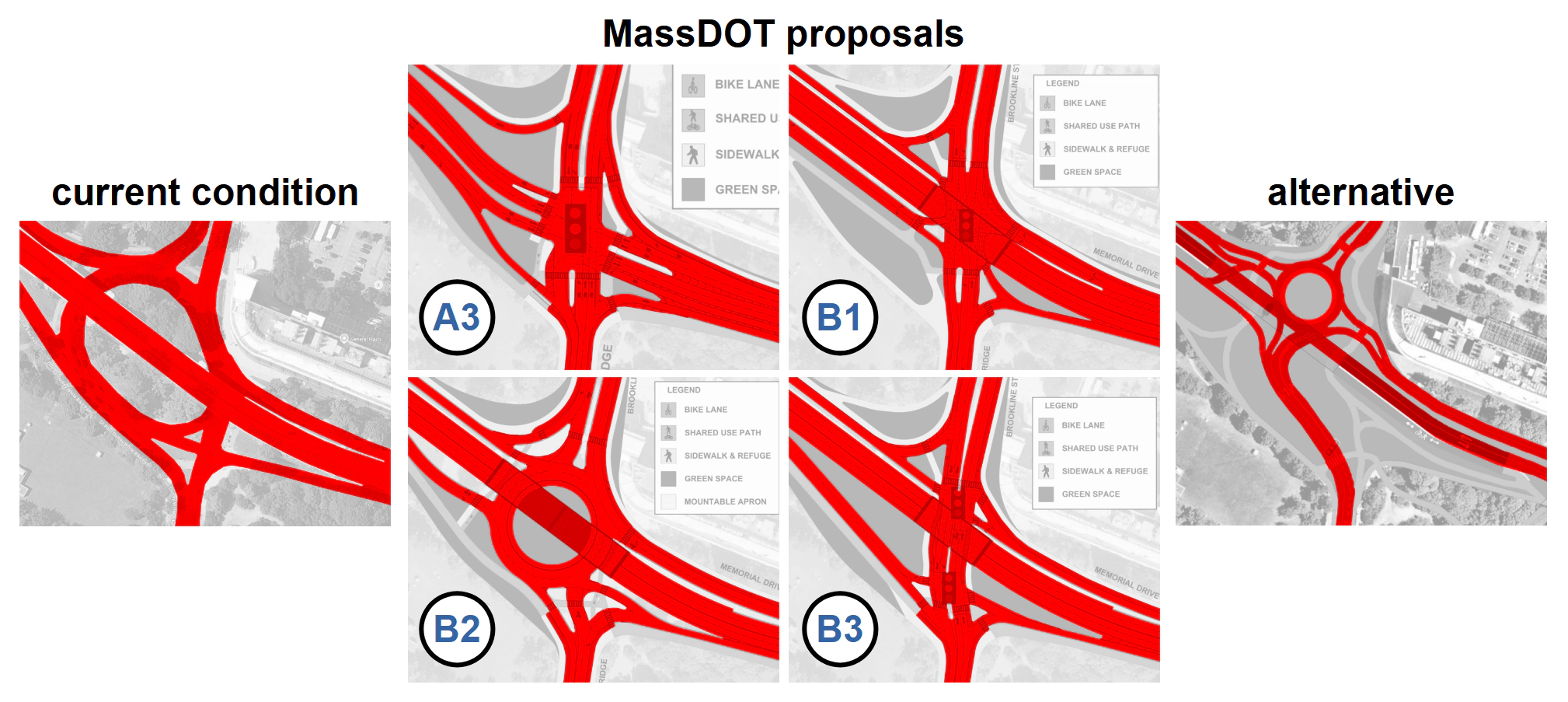
As you can see, none of MassDOT’s proposals make a significant dent in the amount of paved roadway, nor to the distance between the riverfront parkland and the adjacent neighborhood.
And finally, here is the comparison table again, this time including the alternative design proposal as well.
The table includes the following:
- The # of lanes to cross going north-south, e.g. from the Morse playground to the BU Bridge
- The # of lanes to cross going east-west, e.g. along Memorial Drive on the PDW river path
- The distance to cross the intersection (from the start of the first crosswalk to the end of the last crosswalk) in either direction, as well as % change relative to the baseline of the existing intersection
- The approximate area of the paved roadway2, and again % change compared to the current conditions
It’s important to note that these are just the metrics that could be estimated from the presentation materials, and certainly don’t capture the whole picture. For example, this makes alternative B1 look OK, at least compared to the other 3 proposals from MassDOT, since it has the most reduction in roadway area (~11% rather than ~3%) and increases the river path crossing to “only” 4 lanes. But as discussed above, B1 will probably have long pedestrian wait times on a cramped traffic island given the signal operations necessary for a SPI to function effectively.
As the design process advances and details like signal cycles get worked out, additional quantitative metrics should be calculated and shared with the public (e.g. things like pedestrian wait times) to provide a fuller and more objective picture of the designs.
Which leads into the next section…
Requests for MassDOT
The below exchange from the Q&A captured the underlying problem in a nutshell:
Charles River Conservancy representative: I just wanted to reiterate all the comments about slip lanes and pedestrian and bicycle safety and working very closely with DCR to keep Mem Drive a parkway and make it feel like a place that people want to walk along, bike along, just chill out. It would be very interesting to see more investigation if we can reduce the number of lanes as a traffic calming measure, but also reducing impervious surfaces, as we know more roadway equates to more pollution that runs into the river.
Project team member/presenter: Obviously, our intent is to try and limit the impervious areas and reduce the number of lanes. It’s a balancing act, as you may know.
Again: every. single. proposal. has an increase in the number of lanes. This intent is very much not obvious, and in fact did not come through at all in any of the designs. Far from doing any balancing, these proposals clearly weight motor vehicle throughput above all else.
There seems to be a serious mismatch between the publicly stated goals for the project vs. the actual design outputs that were presented, to the point of raising serious concerns about the process itself and whether it can actually lead to an intersection redesign that’s objectively better.
Transparent, quantitative metrics
For that reason, it’s important that the MassDOT project team be as transparent as possible with the public.
One immediate action that can be taken is to publish/share all relevant traffic data (being sure to specify the dates/times of each data collection), including:
- the old traffic counts that were used in the traffic modeling done so far, which were the basis of eliminating some of the earlier concepts (e.g. A1 and A2)
- the most recent traffic counts - the presentation says under “key items completed” is “Traffic count program completed (Includes pedestrian & bicycle counts)”
But more importantly, as the project progresses, any metrics used to compare and rank design options should be quantified wherever possible, also noting the % change relative to the baseline of the existing intersection. This way, members of the public can judge for themselves whether a design truly is an improvement over current conditions, rather than having to take the team’s word for it. And maybe having to think of the designs in more concrete terms will help the project team better translate community input into real and meaningful design outputs, rather than just incongruously-applied buzzwords.
Below are a few metrics that come to mind, but MassDOT should consult all relevant stakeholders to solicit additional measures of success.
Measures of pedestrian/cyclist safety and access
- The below metrics, for both directions: crossing N-S between Cambridge and the river, and crossing E-W along Mem Drive/using the river paths
- Total # of lanes to cross
- Total distance to cross intersection
- Time to cross intersection, taking into account signal phasing and any waiting on traffic islands in the middle
- Pedestrian wait times/signal cycle length - if someone just missed the walk signal, how long do they have to wait until the next opportunity to cross?
- The turn radii throughout the design, and the expected vehicular speeds associated with each
- In particular, highlight the expected range of vehicular speeds approaching any crosswalks - particularly yield-controlled ones, where rates of yielding to pedestrians are directly correlated with driver speed.
- Count and categorize all the potential conflicts between vehicles and VRUs, similar to the vehicle-vehicle conflict point diagrams in the previous section.
- This should also make note of particular risks such as double-threat crashes.
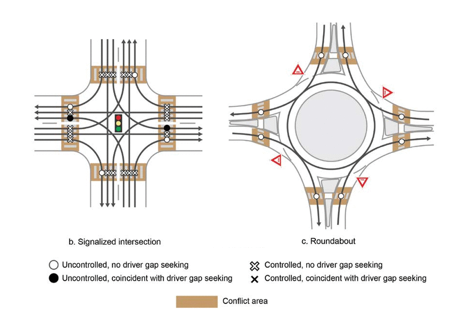
Measures related to traffic operations
As mentioned above, MassDOT eliminated option A1 (an at-grade signalized option that was more compact than the others) due to “Poor overall operations” and “Extremely long queues which do not clear during peak hours.” But these criteria raise a lot of questions:
- What counts as “poor” vs. “acceptable”?
- How long is an “extremely long” queue?
- Are we talking extending so far that it blocks Mass Ave or River St/Western Ave cross traffic? Because less than that seems fine - Memorial Drive is actually very well-suited for queuing cars given it has little local circulation and few cross streets (the only streets that “fully” cross being the river bridges themselves).
- Is the issue that the long queue is actually impeding traffic flow elsewhere? Or is it merely that it “looks” bad? If you take one long queue and halve its length by adding another lane, is that actually an improvement for those drivers if they’re all headed to the same 1-lane bottleneck and will take the same time to get to their destination anyways?
- Is it actually reasonable or even realistic to demand that queues completely clear during the peak hour? Again, the heaviest flows though this intersection are all going to the same bottleneck on the BU Bridge.
So again, here’s some quantitative metrics to publish once more details like signal cycles and more precise geometry get worked out. These would be preferable to the opaque “level of service” letter ratings that the team is currently using in their rubric.
- What is the vehicles/hour throughput of the intersection for traffic in each direction?
- In particular, what is the combined throughput for movements feeding into the BU Bridge southbound lane?
- How does that value compare to the maximum capacity of that lane as set by the Comm Ave signals?
- If the design has additional capacity over that of this bottleneck, justify that excess.
- How “fair” are the flows into the lane? Are they evenly balanced, or are 5 Mem Drive EB cars getting onto the bridge for every 1 car from Cambridgeport? Does this hold up with realistic, not idealized, driver behavior?
- What percent of the intersection’s capacity is used throughout the whole day, not just during brief peak times? Is it sitting mostly empty/severely underutilized for long periods?
- State the design and control vehicles, particularly when it comes to:
- Setting minimum turn radii
- Setting lane widths
- Any increase in the vertical clearance under the Reid Overpass (was unclear from the presentation whether MassDOT is actually trying to do this, but mentioning just in case)
- Anything that’s heavier/bigger/requires wider turns than an MBTA bus needs significant justification, given trucks aren’t allowed on Mem Drive (with strict height restrictions of 9’ and 12’ on either side), and directly north of the intersection is a dense residential neighborhood
- Total time to get through the intersection, for every movement
- And generally less important/informative than time, but just for completeness: queue lengths
- More accurately catalogue the numbers/types of potential vehicle-vehicle conflict points, reflecting the actual design (since again, the above diagrams are generic/textbook ones)
There’s likely more technical metrics out there that aren’t really informative for laypeople, but those should still be shared as there’s quite a few advocates out there with traffic engineering expertise.
Measures related to parkland
- The overall roadway surface area (meaning curb-to-curb area dedicated to motor vehicles, not things like sidewalk-level paved paths), calculated for the whole project area
- Net change in parkland area that is contiguous with the riverfront
- Number of existing trees that need to be removed, particularly mature trees
- The buffer distances between the roadway and the river path, which correspond to the expected noise and pollution levels along the path
More general asks
- For options with an overpass, the overpass should not have more than 2 motor vehicle lanes. If more, a thorough justification needs to be given.
- The traffic models MUST account for realistic local driver behavior, particularly box blocking. Validate the accuracy of any models against existing intersections in the areas that see these behaviors (e.g. Land Blvd/Gilmore Bridge/Rt 28), before using any of their outputs to justify design choices. Otherwise, these models give signalized intersection designs an unfair advantage.
- Account for induced demand, and consider whether a design will remain viable for congestion relief in the long term.
- Include dedicated bus facilities:
- At the very minimum, the soon-to-be high-frequency 47 route must be accommodated.
- The revised 85 route should be considered as well.
- Designs should be safe 24/7/365, rather than relying on the presence of traffic to modulate roadway speeds, or even to indicate traffic flows (e.g. how likely is it for someone to drive into the PDLT lane across the intersection from them, if there isn’t an oncoming car waiting in it?)
- Wherever possible, separated walking trails and cycling paths are preferable to shared use paths. The river paths have always had a mix of recreational vs. commuter use, and combined with a widening mix of micromobility devices, this means a broad range of user speeds that requires extra care in path design to accommodate safe passing behavior. If separated paths are not possible, the shared use path should be at least 14’ wide to accommodate the peak volumes of path users seen here.
- The construction phase of this project would be a perfect opportunity to pilot test a road diet on Memorial Drive, down to 1 travel lane each way with a center turn lane.
- One can be implemented inexpensively and adjustably using quick-build methods like road restriping and jersey barriers.
- The 4th lane can be turned over to pedestrian and cyclist use, providing more space for river path users without needing to increase pavement area on the riverbank itself.
Show, don’t tell…
If MassDOT really insists on pursuing the 4 intersection concepts they presented in January, they should:
- indicate what steps they are taking in the design (rather than relying on enforcement) that would prevent the issues observed at other, similar intersections in the area
- implement those interventions at analogous intersections in the area first, to demonstrate that they are actually effective
For example, if MassDOT solved the box-blocking issue at the notorious Land Blvd/Museum Way/Rt 28 intersection, then it would be much more believable that their designs would not induce those same problems at the BU Bridge.
Or if they were able to implement changes at Mem Drive/Mass Ave that reduced crashes to the point that it was no longer in the top 200 high-crash intersections in the state34, option B3/the tight diamond design could be worth consideration.
But as it stands currently, the public has been given very little reason to trust that the state will actually prioritize safety, given the failure to address long-standing issues at other locations under its jurisdiction. This includes several along this very same corridor:
- Memorial Drive/JFK Street
- used to be in the top 5% bicycle crash clusters in MPO35
- Memorial Drive/Flagg St
- top 5% intersection crash cluster in MPO
- Memorial Drive/River St
- top 5% intersection crash cluster in MPO
- has also been in the state-wide top 200 in past published clusters
- Memorial Drive/Western Ave
- top 200 crash cluster, state-wide
- Memorial Drive/Mass Ave
- top 200 crash cluster, state-wide
- top 5% bicycle crash cluster in MPO
- Land Blvd/Gilmore Bridge/Route 28
- top 200 crash cluster, state-wide
- top 5% bicycle crash cluster in MPO
- top 5% pedestrian crash cluster in MPO
That’s a lot of top-ranked crash clusters on a short 3.5 mile stretch of road in a single city, considering it’s out of an MPO spanning 97 cities/towns and 1,360 square miles, with ~3 million residents. And again, these problems have been on the radar for decades. State roads and intersections are some of the highest-crash locations in Cambridge, yet the city is unable to address them due to lack of jurisdiction. The state needs to step up to enable cities like Cambridge to meet their Vision Zero goals.
MassDOT should demonstrate that they can get it right and do quick-build fixes at these other locations first, before expecting us to believe that despite all appearances, their presented plans for this intersection (which requires major construction due to the overpass, and therefore will be cemented for probably the next century) are actually an improvement.
SPUIs and PDLTs are trickier as they are relatively uncommon in the Northeast. It does look like another ongoing MassDOT project, the Columbia Road and Kosciuszko Circle at I-93 roadway reconstruction36, may possibly implement a displaced left turn design. Not clear if that project will break ground before this one, but if it does, it could be a good opportunity to observe if DLTs are compatible with the local driving culture.
Footnotes
-
Depending on further traffic analysis, the design may or may not include the bypass lane shown in the diagram, which would technically make a very short segment of the roundabout be 2 lanes wide. However, in either case there is only 1 circulating lane. ↩︎
-
Table notes:
- * Within a rectangular area around the main intersection (as in this image). While this ideally would’ve been calculated for the entire project area, the way MassDOT’s concept design images were cropped meant using the most zoomed-in boundaries in order to have a fair/equivalent comparison between different designs. This also does not include shared-use paths.
- ** Technically 0, given that pedestrians and cyclists can use the overpass, but this is the number of lanes for the at-grade crossing.
- *** Based on tree locations noted in DCR’s fall 2024 construction plans.
-
The William J. Reid Overpass was built in 1940, meaning it’s now 86 years old. And despite repairs, including a full closure for several months back in 2013 to address structural issues found during an inspection, it continues to deteriorate and needs replacement. ↩︎
-
The rotary is included in the 2006-2015 HSIP Bicycle Clusters, which was the earliest published online. It’s possible there may be older clusters, given the federal Highway Safety Improvement Program/HSIP was established by a 2005 act of Congress. ↩︎
-
“Thousands” is probably a surprise to many people, so sources are as follows:
- Boston’s annual bike counts have a count location on the BU Bridge itself. Counts exceed 2k daily bikes most years, with 2.7k bikes counted one day last summer.
- The number of pedestrians is typically 2-3 times the number of bikes, as per counters MassDOT has on the bridge.
- These are just bridge counts, which don’t even include all the people going east-west on the Paul Dudley White river path. While all-day counts aren’t available, past evening peak counts from 2009-2014 found the river path segments on either side of this intersection had several hundred users in just a 2-hour period.
-
MassDOT actually recently (on Dec 21st) installed flexposts on the BU Bridge after years of advocacy from the BU Bridge Safety Alliance, but these were 100% knocked over by Jan 6th. This really highlights just how unsafe the bike lanes on the bridge are: every knocked-over flexpost could have been a close pass/sideswipe of a cyclist in the bike lane. ↩︎
-
Discussions around some form of “urban ring” transit have been going on for decades (the first-ever such proposal was made 2 centuries ago, in fact), although stymied by lack of leadership and funding at the state level. Not all proposals route this ring along the Grand Junction, but most do. And interest is still alive and well: for example, there was a study released in Fall 2024, commissioned by the Cambridge Redevelopment Authority (which primarily deals with Kendall Square, and as such has a vested interest in transit upgrades serving the area), on the feasibility of future MBTA transit on the Grand Junction Corridor.
This study recommended trains that were shorter than “standard” commuter rail trains but still compatible with CR tracks and stations. Other people much more knowledgeable about rail transit have written about why this is a bad idea and why Green Line-style light rail trolleys would be better; to try and summarize:
- The aforementioned trains would be an absolute unicorn, requiring a high level of customization that would make procurement and maintenance a nightmare.
- The Grand Junction tracks cross several busy major arterials in Cambridge (Mass Ave, Main St, Broadway), and the delays caused by having railroad-mode transit (requiring gate arms coming down for several minutes at a time) would screw up travel along those corridors to unacceptable levels - necessitating extremely costly and disruptive construction to implement grade separation. On the other hand, light rail would not need gates, and would simply be able to cross in sync with parallel car movements.
-
The MBTA actually requested an exemption to the 22’6” rule from the DPU back in 2023 for the reconstruction of a pedestrian bridge over commuter rail tracks at Back Bay station. In that request they stated that the requested 21’1” minimum clearance “will not interfere with any future plans for electrification of the commuter rail system.” For light rail e.g. Green Line trolleys, the preferred vertical clearance is apparently 21’6” over top of rail, though lower may be possible if MBTA grants a waiver. ↩︎
-
Highlighting this in particular as a thin slice of the parking lots on one or both sides of the tracks may be needed to fit these connections, and those abutting properties belong to MIT. But MIT stands to benefit from facilitating these connections/it would be a good deal for them too. ↩︎
-
Recent upgrades to the traffic signal pattern and lane assignments there improved pedestrian/cyclist safety and increased vehicle throughput by 13%. These changes were first proposed by Professor Peter Furth of Northeastern University/the BU Bridge Safety Alliance in 2023 and eventually implemented in 2025 by MassDOT & the city of Boston’s Transportation Department. More recently, Furth has also proposed an alternative design for this intersection. ↩︎
-
Now if MassDOT’s plans were coupled with a total reconstruction of the BU Bridge and/or Comm Ave intersection to somehow increase the southbound capacity, then they’d make slightly more sense (despite still being unsafe for peds/bikes)…but that’s not happening anytime soon given both went through extensive construction relatively recently. The 2.5-year, $19 million BU Bridge rehabilitation project substantially wrapped up by the end of 2011, and the $110 million replacement of the Comm Ave bridge over the Pike wrapped up in 2018. ↩︎
-
A significant chunk of 2025 data for the Central Square stop is missing/NaN, likely due to River St/Carl Barron Plaza construction work requiring the usual Central Square stop to be relocated. This missing data means travel times between the 2 stops cannot be calculated for all trips. However, this does not affect the Mountfort St data/plot, and the remaining 2025 data is still informative (and shows similar patterns to 2024). ↩︎
-
From querying the MassDOT IMPACT Crash Data Portal. ↩︎
-
Crossing here is necessary since given the missing 4th crosswalk across Rt 28 at the adjacent intersection with the Gilmore Bridge/Land Boulevard. ↩︎
-
A conventional 4-leg intersection has 32 conflict points, 16 of them crossing conflicts (the most dangerous kind, angle/T-bone crashes etc.). A 1-lane roundabout has 8 conflict points, 0 crossing. A 2-lane roundabout has 24 conflict points, 8 crossing. Finally, there are the (relatively) newer turbo roundabouts, which are basically 2-lane roundabouts but with additional channelization/dividers between the inner and outer lanes that reduces it back down to 14 conflicts, 4 of them crossing. ↩︎
-
Displaced left turn/DLT seems to be the most commonly used name, but it is sometimes also called a continuous-flow intersection. ↩︎
-
This unsafe mess could be solved by changing the traffic signal phasing to eliminate conflicts between crossing path users and turning vehicles, but of course “traffic operations” are given priority. ↩︎
-
MassDOT does seem to be hinting at a desire to accommodate larger vehicles through here - for example, they highlighted the current 8-ton weight limit of the current overpass as one of the main issues, and for concept B2 listed one of the cons as “tight geometry limits large vehicle movement.” ↩︎
-
Road safety advocates are currently pushing the state legislature to expand truck safety regulations that were previously enacted in 2022. However, even if that expansion passes, MA state rules can only be applied to trucks leased/owned by the state, its municipalities, and associated contractors, not touching the many privately owned and operated trucks and out-of-state trucks that drive on our roads. Federal action would be needed for that, but does not seem likely anytime soon. ↩︎
-
This is a ballpark estimate since again, MassDOT has not publicly shared the relevant data. City of Boston traffic counts since 2024 show total BU Bridge traffic volumes (NB + SB combined) hovering between 25.3k-31.4k MVs per day. And old Memorial Drive counts presented by DCR in 2019 (though the counts themselves may have been conducted earlier than that) show ~20k MVs per day using the Reid Overpass - it would be interesting to see whether this has changed in the wake of the pandemic and the rise of remote work. Summing those together is probably a decent estimate of total traffic volumes through this interchange. This does miss movements going between Memorial Drive and Brookline St, but only a small portion of cars make those specific turns. ↩︎
-
B1 is unclear, as standard SPUIs have yield-controlled/not-signalized right turns, but in this case the pedestrian crosswalk goes across both the right turn lane and the signalized left turn together… ↩︎
-
Technically, there is a 3rd option of making the whole street 2-way, but this could create a safety issue given this is right in front of an elementary school. While this would enable retaining the current curbside boarding for kids who get to/from school via car or bus, it would also be one more lane to cross for kids who walk to school. A 2-way setup would also likely require significant street parking removal: as one of the travel lanes needs to be 11 ft wide for buses, the street width falls just short of being able to accommodate a lane of parking. ↩︎
-
This would require removing the existing (unprotected) bike lane on the one-way section of Waverly, as the street is only 18’ wide in some spots which is barely enough for even just 2 car lanes. But if the Grand Junction path is executed well, with good neighborhood connections, it could more than compensate for this removal. The question is whether the project timings will align, as the Grand Junction ↩︎
-
Ari Ofsevit’s original quick-build concept also had bus priority for the CT2 as well. The CT2 is actually being merged into route 85 this April, and this revised service largely follows the same route (including the relevant portion of Vassar > BU Bridge), and will continue to be weekdays-only, with infrequent service outside of peak times. While this sketch proposal does not include bus priority for that route (the soon-to-be all-day every-day frequent service route 47 was the higher priority), it could be possible to have a median u-turn west of the overpass that allows the CT2/85 to access the 47’s bus lane as well. Alternatively, there might be room for a bus lane on a short segment of Mem Drive, though this would reduce parkland. ↩︎
-
As drawn, this proposal retains the existing “no left turn” restriction that prohibits drivers from turning left from Magazine St onto Mem Drive eastbound. This left turn would only be allowed for buses, which would have a transmitter that activates the traffic signal as they approach.
While the signal could potentially be modified to facilitate left turns for cars as well, removing this turn restriction would likely turn Magazine St into a major cut-through route and undermine the bus priority here. In the past, this might have been able to function as a shortcut that only locals knew about, allowing Cambridgeport residents to bypass rotary traffic, but the advent of navigation apps like Google Maps and Waze means this kind of thing is no longer possible. ↩︎
-
That being said, MassDOT’s design for that project could be much better as well, and suffers from the same issue of large intersections and reclaimed space being wasted on traffic islands/medians. ↩︎
-
During the presentation slide about the existing conditions of the Reid Overpass, the presenter said: “The vertical clearance below is 14 feet 5 inches, and does not meet modern standards and can create challenges for larger vehicles.” It was unclear if these were intended as separate points, or if MassDOT actually wants to increase the clearance? Hopefully it’s not the latter, which would make no sense given the BU Bridge itself has a 14’ vertical clearance and Memorial Drive has 9’ and 12’ vertical clearances to the east and west of this intersection, respectively. ↩︎
-
This would also address the “complications for grading of the circle” that MassDOT lists as a con for a 2-lane roundabout (the eliminated A2 alternative, and presumably this is an issue for alternative B2 as well). ↩︎
-
Feel free to check these numbers for yourself - this online tool is useful for getting elevations. ↩︎
-
In an ideal world, it wouldn’t be this binary choice between an overpass and massive at-grade intersection width; there could theoretically be a 3rd option where MassDOT designs a compact 100% at-grade option suitable for a future where VMT has been greatly reduced thanks to improved transit and multi-modal connectivity. But that is incredibly unlikely to happen. ↩︎
-
Realistically, “decades” is the timescale of the things that can actually enable the level of mode shift needed to reduce lanes here, e.g. Allston multimodal/I-90 reconstruction, or the MBTA doing another transit expansion via the Grand Junction. Think about how long it took for the GLX to be completed - first mandated in the 1990 Big Dig settlement, but planning didn’t start until 2006, construction began 2014, and finally was finished in 2022, technically 2023 if you count the redo of the incorrectly installed rails that were discovered after the fact. ↩︎
-
“Without interruption” isn’t always a bad thing, either. Again, the actual problem is speeding and lack of gaps/opportunities to safely cross. A slow but steady flow of cars is what makes roundabouts efficient yet still (by virtue of low speeds improving driver yield rates and reducing crash severity) safe and crossable. ↩︎
-
The likely answer is it can’t be reduced, but it’s just good to make sure design choices like this are justified (e.g. state the control vehicle), rather than just going with something simply because that’s how it’s always been. ↩︎
-
It’s possible that the Mass Ave Bridge road diet (first piloted in November 2021 with traffic cones) reduced crashes here - again, the most recent crash cluster report available is for 2019-2021. When the road diet was made more permanent a year later with flex posts, this included some changes within the diamond intersection itself. A preliminary glance at IMPACT portal data shows that in 2021 vs. 2022 (bridge-only traffic cone road diet), there was a marked drop in the proportion of injury crashes. And then in 2022 vs. 2023 onwards (flex post installation and road diet extended to intersection), total annual crashes dropped by more than half. In which case, seems like there’s some obvious lessons to be learned here. ↩︎
-
It was in 4 consecutive clusters, from the 2006-2015 cluster to the 2009-2018 cluster, before dropping out. Potential related factors: reconstruction of the Anderson Memorial Bridge from 2012-2016, and construction of the Quincy/Dewolfe protected bike lanes at the end of 2020 providing an alternative N-S route across the river. It’s possible this intersection might rejoin the top 5% though, given increased development in and around Harvard’s Allston campus has driven (and will continue to drive) increased traffic of all modes through the intersection. It remains to be seen whether the Memorial Drive Phase III road diet can offset/prevent this from increasing crashes. ↩︎
-
The design process for that project appears to have been much more thorough than this one. The presentation includes a crash analysis breaking down location/type/VRUs, actually has a section looking at paths/protected bike facilities, and examines the local transit network. To be fair, it is a significantly larger and more complicated project, with double the funding. And the proposals are still not great for pedestrians and cyclists, though that’s at least understandable given this is an interchange with an actual highway, I-93, as opposed to a riverfront parkway like Memorial Drive where there’s simply no excuse for subpar pedestrian and cyclist infrastructure. But it shows that MassDOT does have the ability to consider these things early on, but didn’t this time for some reason. ↩︎