NOTE
A shorter summary of this writeup, focusing on the key points that are most relevant to the selection of the main intersection design/layout, can be found here.
Summary
While the latest design options for the Reid Overpass project are a slight improvement over what MassDOT presented in January, they still fall short of the mark in terms of addressing safety, improving the pedestrian/bicycle experience, and restoring the area to be a riverfront rather than a highway. In fact, both of MassDOT’s options are concerningly similar to other nearby crash cluster intersections along the same corridor (including ones that rank in the top 200 state-wide), one of which was very recently the site of a fatal crash that resulted in the death of a cyclist.
MassDOT’s approach tries to decouple the roadway design from safety issues. The designs are focused on accommodating the peak 15-minute traffic volumes, a.k.a. the worst 1% of the entire day, while safety is treated as something that can be addressed later with some add-on features once a base design is selected. But the end result of this approach is oversized roadways that retain the highway-like feel of Memorial Drive today, and enable (or even exacerbate!) the rampant, dangerous speeding that underpins most of the safety issues in the project area. Rather paradoxically, MassDOT’s designs will only be safe during the brief periods of the day that there’s congestion.
I ask that MassDOT reconsider design options beyond the 2 they have selected. This includes community proposals, such as the recent “Hybrid” proposal by local advocate Ari Ofsevit. I’d also like to make one more pitch for Alternative C, which is the single-lane roundabout + overpass + crossovers design described in my previous writeup from March (with some recent minor edits to address comments from the project team).
AltC takes the opposite approach from MassDOT: it starts with a design that is safe 24/7, independent of traffic levels, and then has additional features that can kick in to handle traffic spikes as needed. As a result, it remains significantly better than MassDOT’s options in terms of:
- SAFETY - roundabouts are proven to be much safer than signalized intersections (converting the latter to the former can reduce fatal and injury crashes by 78%)
- PED/BIKE EXPERIENCE - river path users get a car-free route over the intersection, while all other movements only require crossing 2 lanes
- RIVERFRONT RESTORATION - AltC reclaims ~0.7 more acres of riverfront-contiguous greenspace vs. MassDOT’s 4-way option, and ~1.3 more acres vs. their TDI option
In addition, it might even perform better traffic-wise: plugging the latest April 2026 traffic counts into a roundabout analysis tool shows that not only can the AltC roundabout handle current traffic volumes, it has a peak hour LOS of C vs. the LOS E of MassDOT’s options. I believe that at the very least, AltC merits further analysis by the project team.
That being said, the AltC pitch accounts for only the last 25% of this writeup (here is a link to jump straight to that section if needed), so whatever happens, I hope the project team will still take into account the feedback/ideas in the remaining 75%, which are generally applicable to any design. Even if MassDOT insists it’s too late to consider anything except the 2 design options that they have selected, this writeup goes over several ways MassDOT could improve upon them/mitigate the harm.
Background
MassDOT’s Reid Overpass project is a once-in-a-lifetime opportunity (quite literally) to fix the unsafe (consistently flagged as a HSIP crash cluster), chaotic, and often-gridlocked intersection of Memorial Drive and the Cambridge end of the BU Bridge. Much more detailed background about this project can be found in the previous writeup, but in short:
- The overpass bridge carrying Mem Drive over the BU Bridge rotary is nearing the end of its service life and needs to be taken down
- All options are (were?) on the table for what will replace it, including rebuilding some version of the overpass, or eliminating it altogether - reconfiguring the intersection entirely, no matter what
- The project area (shown below) extends from Magazine St to Vassar St in the east-west direction, and Granite St/Waverly St to the foot of the BU Bridge in the N-S direction
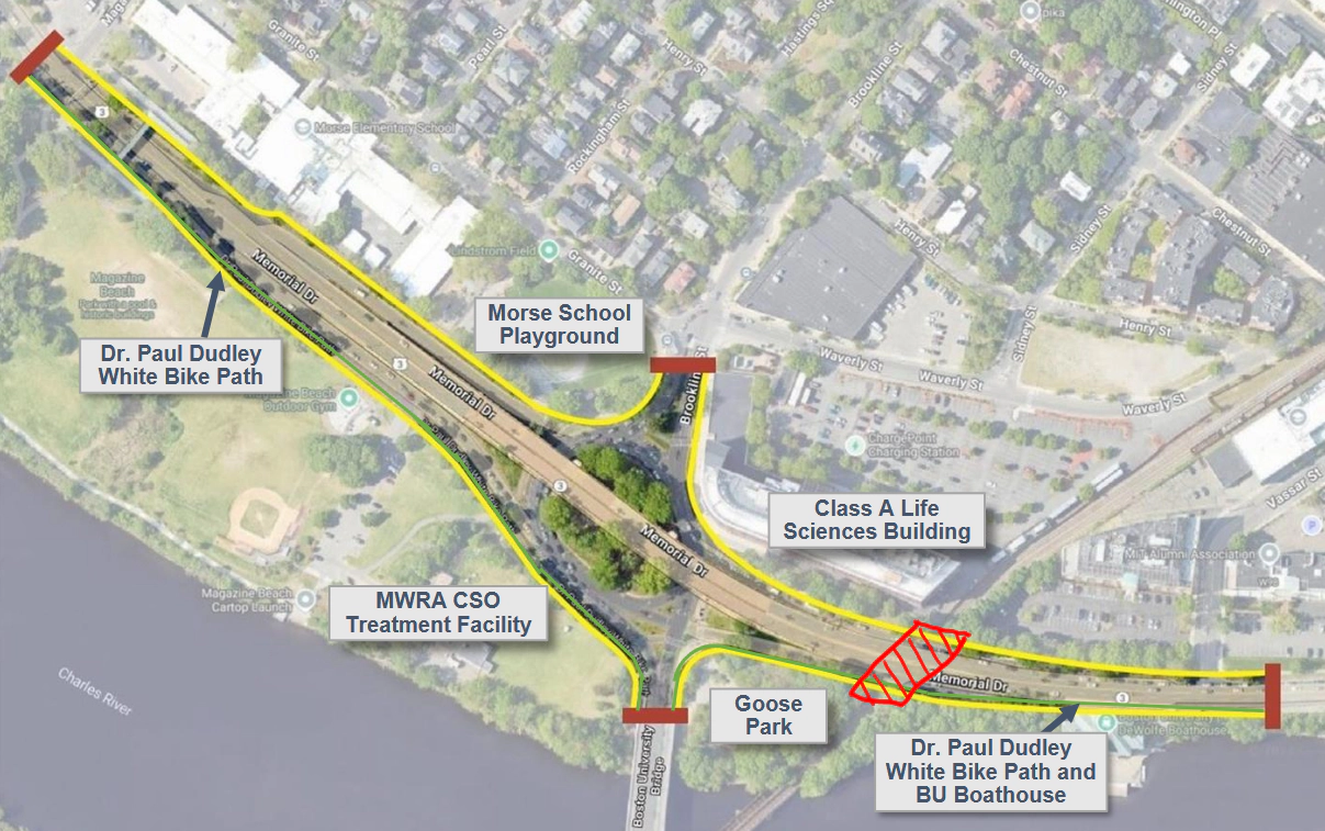
The process
I wrote the March post in reaction to the design options MassDOT presented in January, which were heavily criticized across the board for being oversized, highway-style interchanges that were completely inappropriate for the riverfront/parkland context, prioritizing traffic throughput while not actually solving the many safety issues that exist here for vulnerable road users (VRUs), and in some cases even exacerbating them.
MassDOT has since been working to revise the designs, and a month ago on August 6, they held an in-person open house where the final 2 options were revealed to the public (down from 4 options in January):
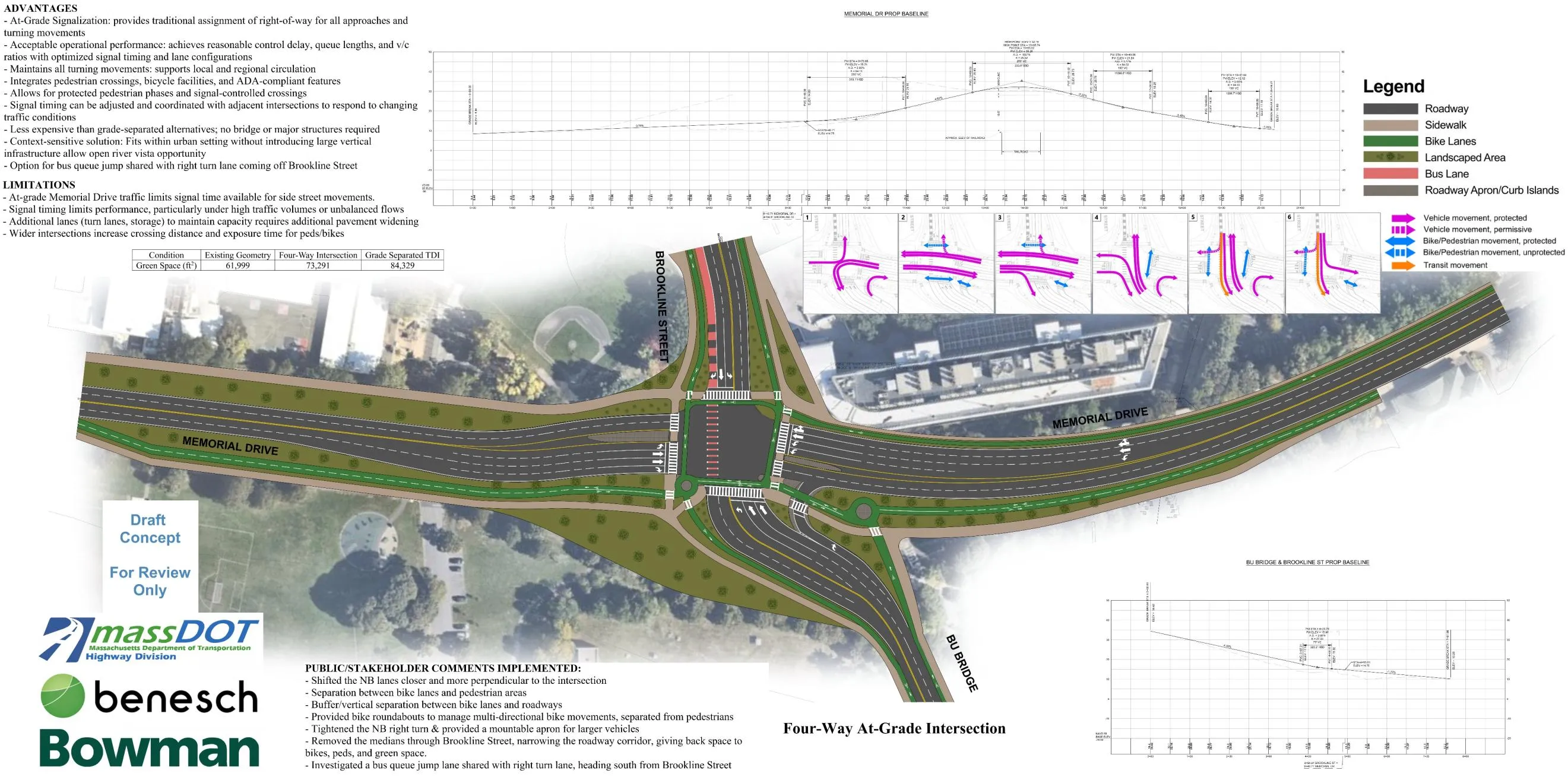
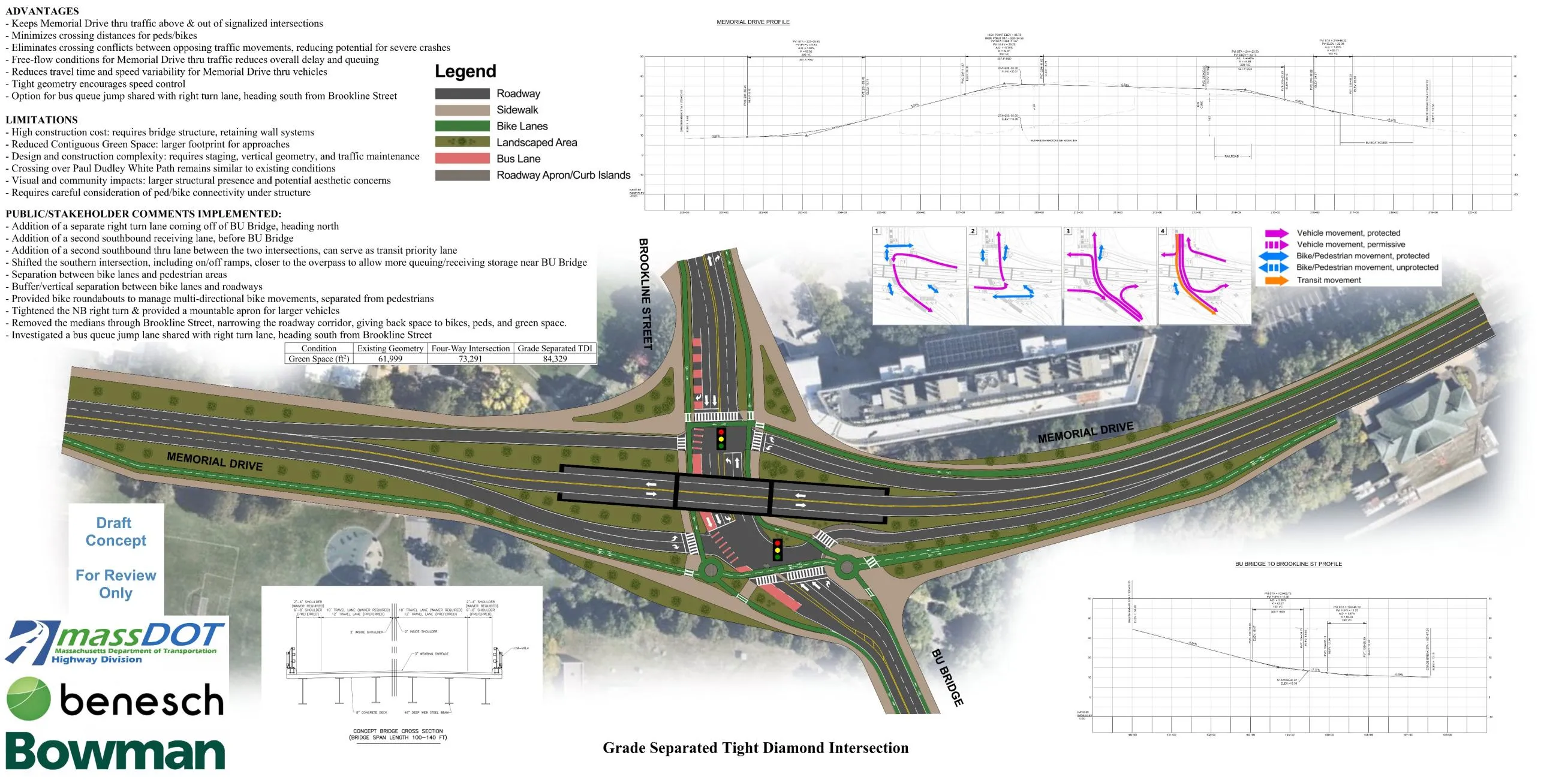
After this latest round of public comment, MassDOT is aiming to pick one of the 2 options as the “preferred concept” so they can finally launch the formal design process. While the project timeline is technically TBD, the status page currently lists a Summer 2029 start date for construction, which does not leave a ton of time for design.
Past this “preferred concept” point, the overall layout of the intersection will be pretty much solidified, though of course there will still be opportunities for public input and some minor design tweaks. But this is essentially the last chance for actual transformative change here - and I’m afraid that neither of MassDOT’s 2 options qualify.
Incrementally better, but still fails to address advocate concerns
First off, I acknowledge and appreciate that MassDOT has done more early engagement for this project than for almost any other project I can remember, such as meeting way back in fall 2024with residents of the adjacent Cambridgeport neighborhood, who regularly deal with intersection traffic backing up into their streets. And of course, a lot of credit is due to the elected officials who pushed for these early conversations to happen, such as the Cambridge City Council, state Senators Brownsburger and DiDomenico, and state Representative Connolly. In between the January and August public meetings, MassDOT also hosted an April workshop inviting a broad range of advocacy groups to provide early feedback on designs. I’m also grateful for the project team’s responsiveness to advocate requests when it came to sharing the traffic data.
But despite these improvements in engagement processes, there still appears to be a significant disconnect between collecting feedback vs. meaningfully incorporating/acting upon that feedback. This is evident in the design progression over the past ~7 months, from the initial January reveal, to the work-in-progress drafts shown at the April workshop, and finally to the August revised design options that the public is supposed to pick a single “preferred concept” from:
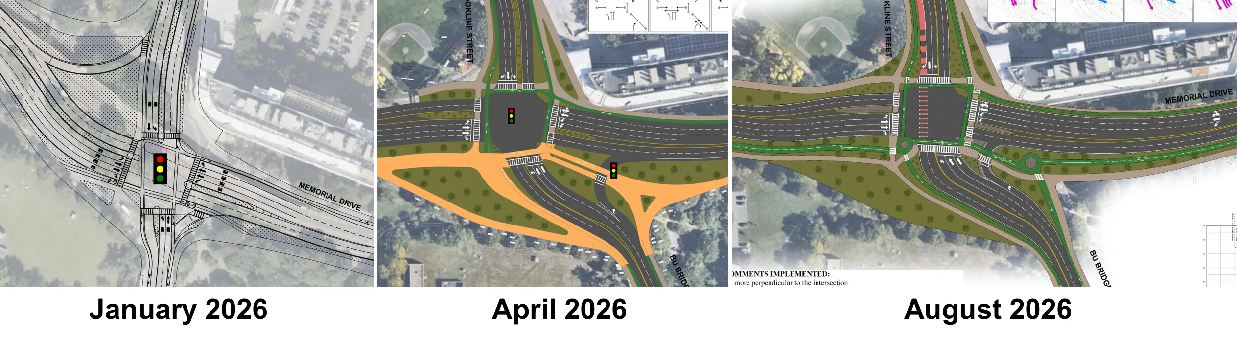
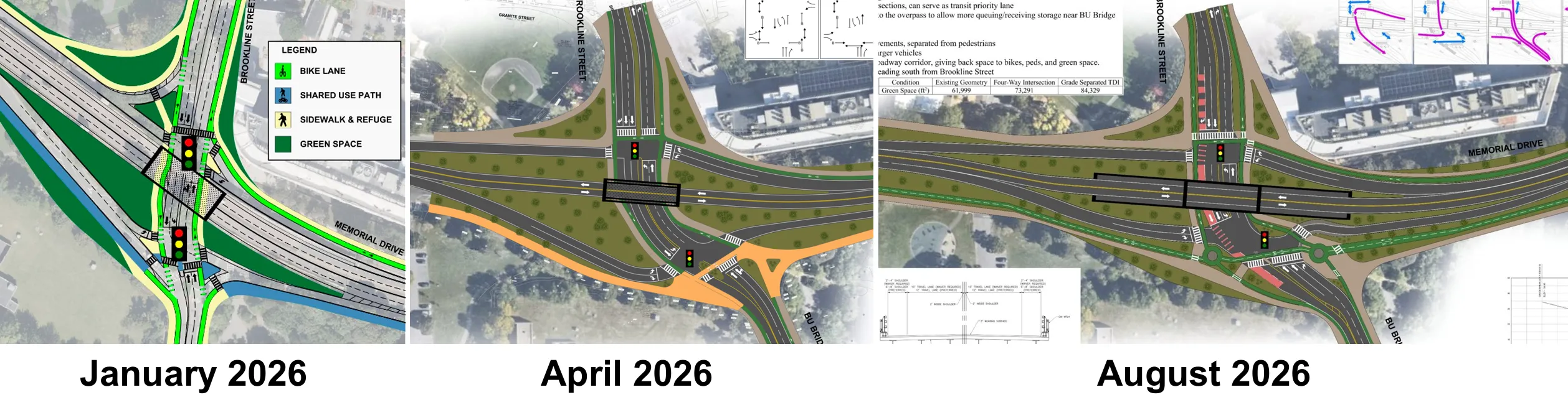
This side-by-side comparison makes it clear that while there indeed have been changes, they are all relatively minor. For example:
- Slip lanes were removed and replaced with regular turn lanes - but those should never have been proposed in the first place.
- Geometry was tweaked so there’s a bit more riverfront parkland reclaimed, and in some cases better routing of paths/crossings.
- In the overpass option, the # of lanes on the bridge was reduced from 4 to 2 - but as previously discussed, it was known from the start that 2 lanes were sufficient, based on multiple rounds of traffic counts and from observing the actual real-life effects of lane reductions during construction in the area.
- A right-turn lane with extremely low usage was converted into a queue jump benefiting the inbound 47 bus.
- Ped/bike placeholder space was fleshed out into separated sidewalk vs. shared-use pathways, with new bike roundabouts
- The latest design documents do provide one of the requested quantitative metrics, the square footage of green space - but do not differentiate actually-usable space contiguous with the riverfront vs. space that is locked up in traffic medians and is only decorative at most. And other metrics that I’d suggested in the previous writeup (the goal being more transparent design comparison and selection) are still absent.
In other words, MassDOT has addressed several low-hanging fruit items, but really has not budged at all when it comes to the core tension throughout this design process: the intersection’s peak capacity for motor vehicle traffic vs. all the other demands on this space, including safety/accommodations for VRUs and the restoration of Memorial Drive into something that belongs to the riverfront rather than tears through it.
Case in point: the biggest advocacy ask has consistently/from the start been for a smaller intersection footprint with fewer lanes, both for safety reasons (reduced crossing distances/pedestrian exposure, reducing vehicle speeds to slow and safe levels) and for reclaiming the riverfront for its originally intended parkland purpose. See the bundle of letters submitted by a range of organizations in response to the January designs, as well as some of the comments from the April workshop1.
MassDOT has since completed the first stage of traffic analysis, and concluded no lanes would be removed (other than the aforementioned easy concession of 4 > 2 overpass lanes). In fact, the TDI has added lanes since the April workshop! This outcome is likely due to MassDOT using peak 15-minute traffic flows for said analysis, rather than a more-reasonable peak hour as advocates have repeatedly requested. More on that later.
So then actually looking at what’s different from January:
- For the TDI option, the number of lanes to cross remains largely unchanged. While the slip lane consolidation mentioned above resulted in N-S crossings being reduced from 4 to 3 lanes total, there are still 5 lanes to cross for river path users.
- For the 4-way at-grade design, it has actually increased in size. The Memorial Drive crossing remains oversized, at 6 lanes (7 if you count the additional slip lane that northbound cyclists need to cross), and the river path crossing has gone from 4 lanes to 6 lanes.
Side note: back in the January presentation, an at-grade design was only mentioned as an alternative that MassDOT had already eliminated, primarily due to “poor overall [traffic] operations” but also citing reasons such as “cycling/pedestrian crossings long and inconvenient” and “lends itself to off-peak speeding”2. But then the concept was brought back, made even larger to address the traffic operations issues, and now is being presented as one of the best 2 options despite the fact that the other listed drawbacks still remain unaddressed! This quiet moving of the goalposts is exactly why I’d requested that concepts be compared side-by-side to each other and to the baseline of existing conditions using concrete, quantitative evaluation metrics.
In addition, it’s not just the physical crossing distances that are long. The signal cycle for both options is 120 seconds long, which translates to long wait times for everyone - pedestrians, cyclists, drivers.
This quote from the “about” page on the project website encapsulates the problem (highlight mine):
We hope to be able to select a preferred concept to take into the formal design process by the end of 2026 so that we can begin addressing the range of safety concerns and accessibility challenges noted by our own team and raised by community members.
In other words, designs are drawn up and decided upon based on traffic considerations first, then safety is “dealt with” afterwards - despite the fact that these things cannot be simply decoupled in this way. This problem was pointed out in January but frustratingly, it seems that it’s still the current mindset.
In a followup email after the August 6th open house, the team mentioned that they were beginning more detailed traffic modeling with Vissim in order to determine "whether either concept performs better for any particular mode of travel" and that the modeling results + public comment would be used. There was no mention of safety.
Does Vissim account for realistic local driving behavior, such as:
- the box blocking constantly observed at Land Boulevard/Rt 28 and other busy intersections of similar nature to the proposed 4-way option?
- the ~50% compliance with “No Turn on Red” restrictions, like what has been observed at the Mem Dr/Mass Ave TDI?
- speeding up on wide roadways when they are emptier during off-peak hours?
Because if not, it will likely overestimate the traffic performance and simultaneously underestimate the downsides these designs have for vulnerable road users.
A comparison with quantitative evaluation metrics
In my previous writeup, I directly compared the January designs to each other as well as to the baseline of the existing intersection, plus an alternative advocates’ proposal. Let’s repeat the exercise with the 2 revised design options from MassDOT, alongside the previous “Alternative C” design from last time (more on that later), as well as a late-game “Hybrid Concept” recently put forth by another advocate.
First, let’s look at vehicle-vehicle conflict points in each design. This provides a rough comparative idea of intersection complexity and the types of crashes that could occur, including which designs are more likely to have more serious crash types.
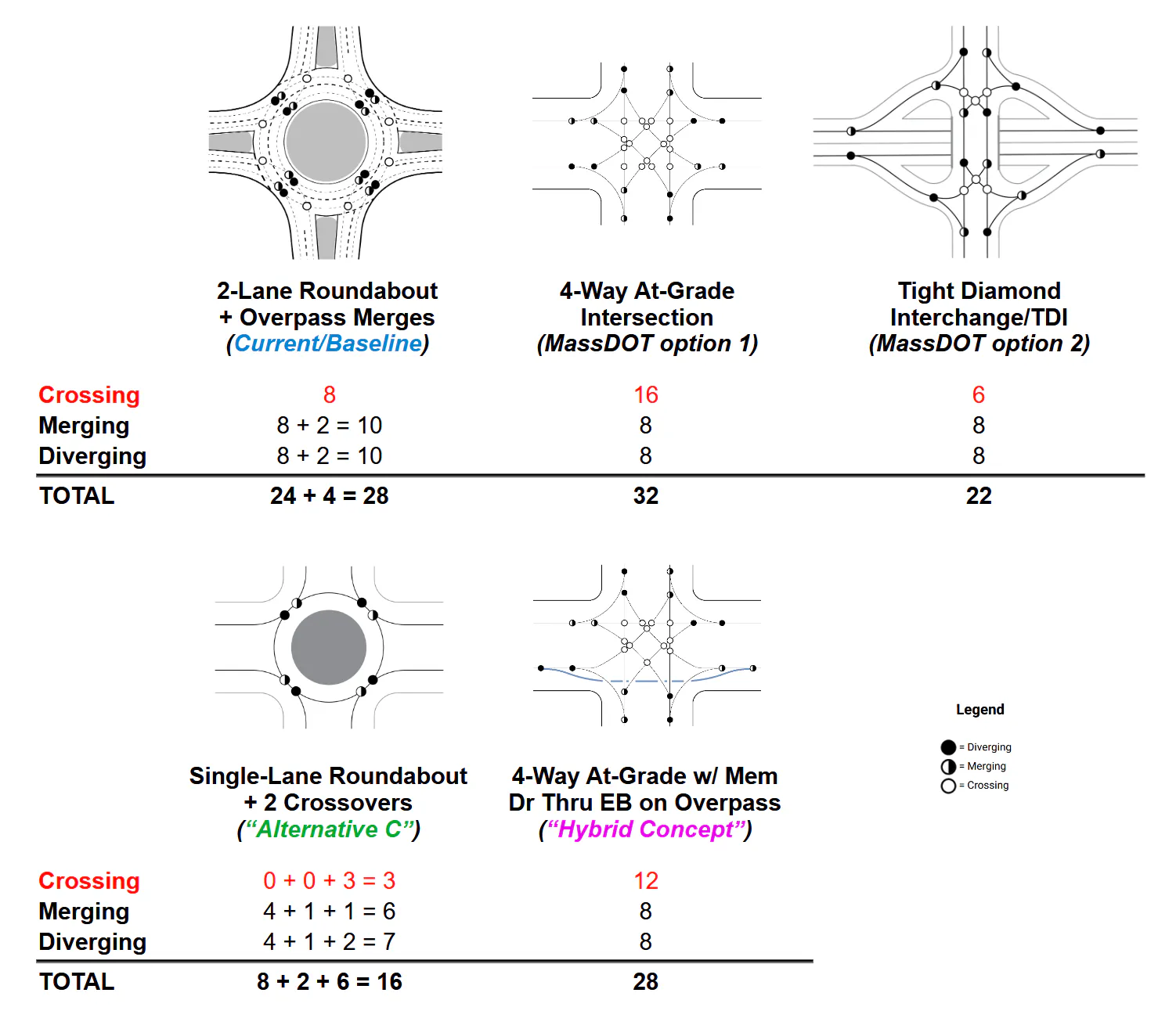
From this we can see that:
- MassDOT’s 4-way at-grade design has the most crossing conflicts of all the designs, specifically twice as many as the current rotary. For reference, crossing conflicts are the most dangerous type, corresponding to angle/T-bone crashes (as opposed to things like sideswipes). And, this design has the most total conflicts as well.
- MassDOT’s TDI option, on the other hand, has slightly fewer conflicts vs. the current rotary.
- The Hybrid Concept lands approximately halfway in between MassDOT’s 2 options when it comes to crossing and total conflicts - which makes sense, since it combines features from both.
- Alternative C still has the fewest crossing conflicts as well as the fewest total conflicts by far.
Next is a visual comparison of the footprint of each design, both looking at the roadway area in red, as well as how much riverfront parkland is reclaimed.
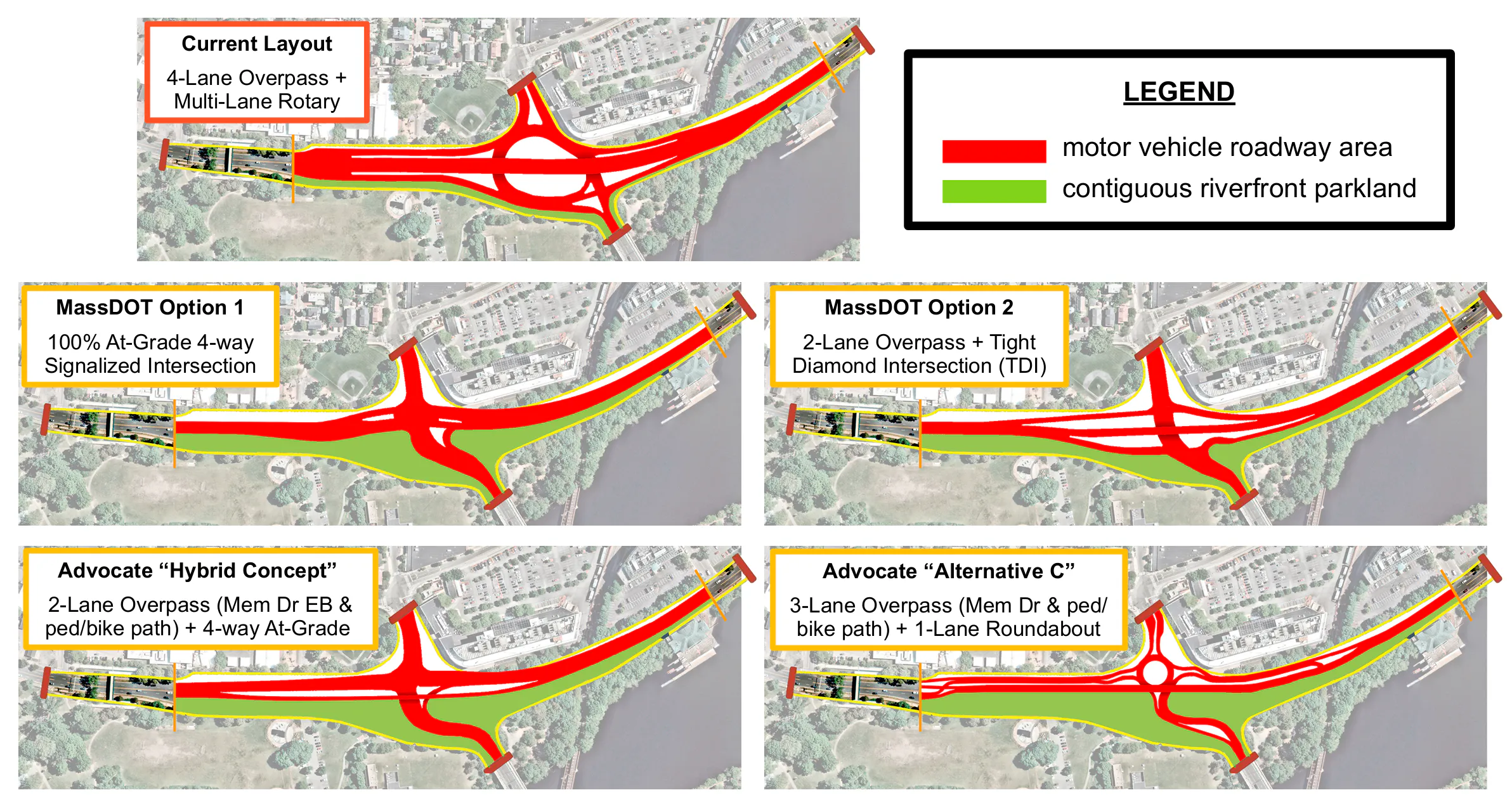
All the options are technically an improvement over existing conditions, but that’s only because the current rotary sets the bar incredibly low, given its 4-lane overpass and oversized circulating lane that basically takes up as much space as physically possible.
That being said, MassDOT’s TDI option clearly fares the worst in terms of parkland, because much of the green space is locked up in medians within the diamond, sandwiched in between roadways and therefore unusable as parkland/for recreation. It’s the same problem that the Mem Drive medians by MIT have - wide green space in a prime riverfront location, yet it only sees meaningful use/any foot traffic on 1 day of the entire year, when Mem Drive gets closed to cars for July 4th fireworks.
MassDOT’s 4-way option actually does reclaim a good amount of riverfront parkland, due to how the intersection has been shifted northward. However, it also has the largest roadway footprint of all the options, as the already-oversized 4-lane cross-section of Memorial Drive swells to 6 lanes at the intersection to accommodate turn lanes.
The Hybrid Concept has similar roadway area to MassDOT’s 2 options, but more riverfront parkland than both.
And again, Alternative C has the least roadway area and the most riverfront green space out of all the options.
The below table summarizes all the above, and includes a few additional quantitative metrics for good measure.
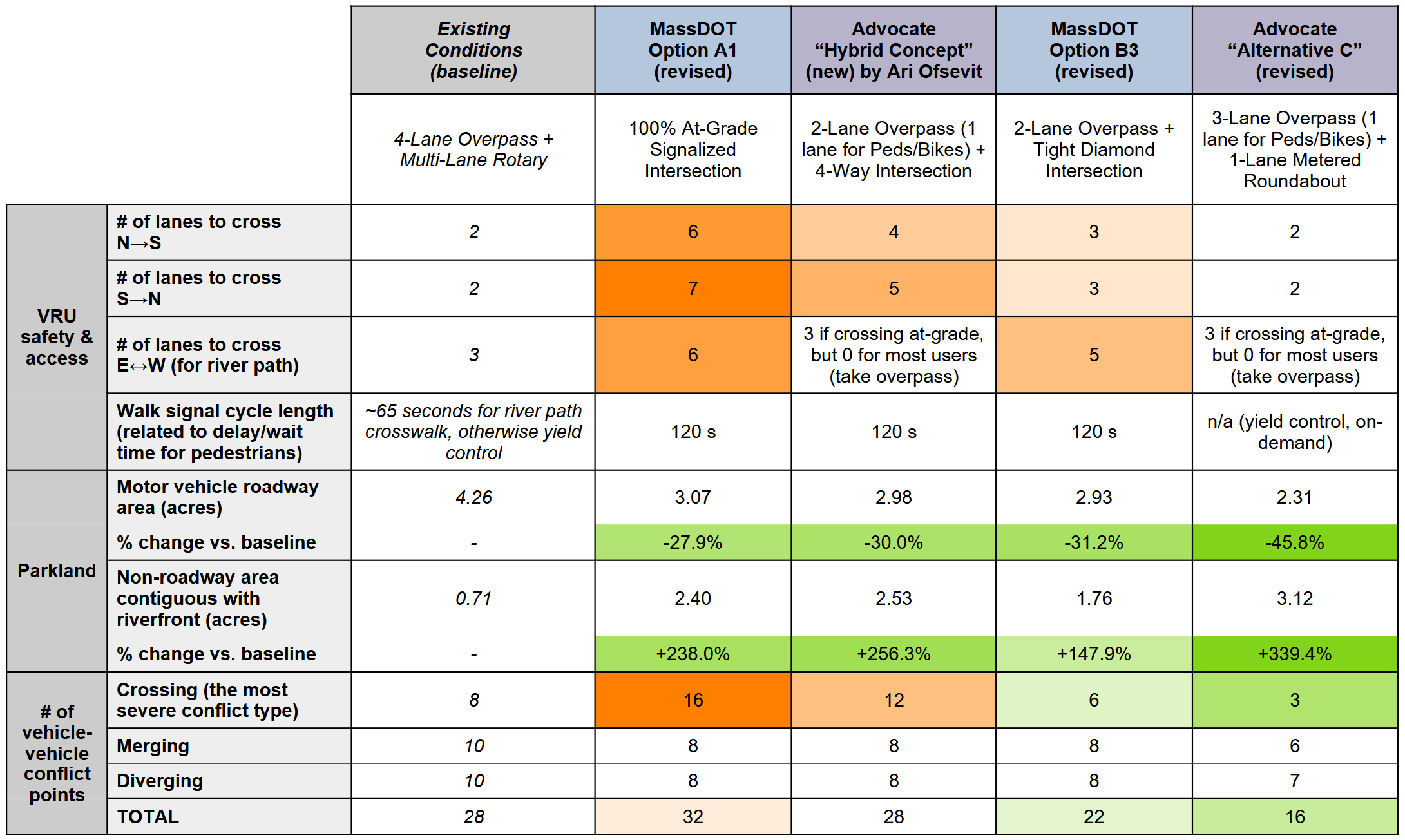
In light of this, I think it’s really hard to call either of MassDOT’s options a real improvement over existing conditions. And that’s even before getting to the really important part: safety issues.
A retreat to familiarity, despite documented danger/dysfunction
Despite how critical I was of MassDOT’s PDLT option, which made it as far as the April workshop before being eliminated, it was at least an attempt to try something new. Meanwhile, the final 2 options MassDOT has settled on ultimately represent a fallback to traditional designs that it is already familiar with. Which by itself isn’t a problem - “don’t mess with success,” right? Except that’s not actually applicable here, because far from being a success, many other nearby intersections with these same designs have a troublingly poor track record of safety.3
If MassDOT insists on using these designs, the burden should be on them to prove that the safety issues at other similar intersections won’t merely be recreated here. As in, they need to demonstrate that they actually understand what’s wrong at those other intersections and outline the measures they are proactively taking in their designs to address them.
Yet instead, advocates are being asked to trust that safety issues will get fixed later once they’ve given their blessing to one of MassDOT’s 2 options. But the public has been given very little reason to grant that trust, given the state’s failure to address long-standing issues at other locations under its jurisdiction, many along this very same corridor.
Now, it’s true that the proposed signal phasing looks great on paper, with almost no conflicts between vehicle movements and ped/bike crossing movements. But anyone who regularly walks or bikes in the area knows that red-light running is ubiquitous, and that “no turn on red” (NTOR) restrictions are routinely ignored.
Here is a video documenting the absolutely abysmal (<50%) signal compliance at the signal-separated right turn from the Mass Ave Bridge onto Memorial Drive. In just one sitting, it captures a constant stream of disregard for and/or confusion around the NTOR restriction, which results in several near misses and one actual crash. Not to mention several prohibited left turn/straight movements onto the Mem Drive on-ramp, as well as other wild behavior - in one instance, someone in the right-turn lane, apparently frustrated by the car in front of them actually stopping to obey the red arrow, uses the bike lane to pass on the right and then continues straight.
And here is another video of a different corner of this same intersection, again showing multiple cars completely ignoring the “no turn on red” signage to drive across an active crosswalk.
This kind of behavior is incredibly common, which is why I’ve personally grown increasingly skeptical of designs that heavily rely on signal separation alone to keep vulnerable road users safe. What steps has MassDOT taken to ensure that these designs won’t suffer from these same issues of poor signal compliance and box blocking? And that the consequences of someone accidentally or purposefully disregarding a signal aren’t deadly?
Simply passing the buck and saying that’s a separate issue for enforcement to deal with is NOT a solution.
Let’s take a look at some precedents. Again, I’m pretty much repeating what I already wrote in March, but since those points still stand I will rehash them here.
100% At-Grade 4-way intersection
This intersection layout is as standard as it gets. As a reminder, the main intersection box has a 5x6-lane footprint. If the BU Bridge > Mem Dr right turn lane is included, then from the perspective of people crossing the intersection is (5-6)x(6-7) lanes.
This is very large. For comparison, the four-way intersections of Mem Dr with Western Ave and River St are 3x4 lanes, and those are already quite unpleasant crossings for river path users. They are also pretty bad in terms of safety:
- The Western Ave currently is a top 200 crash cluster in the entire state, and has been for multiple cycles
- The River St intersection is a top 5% intersection crash cluster in the Boston MPO, and in the past has also been in the top 200 crash clusters
Western Ave (just a half-mile from the project area) is also an example of an intersection next to a bottleneck, and regularly is the site of box blocking, red light running, crosswalk blocking, and failure to yield the right of way to vulnerable road users. This video and this video are just a few examples what river path users have to deal with regularly here.
And all that is despite the fact that both Western and River are one-way streets. Applying this 4-way design to the intersection with 2-way BU Bridge/Brookline St traffic results in an intersection that is even more complex and double the size (including crossing distances) of the Western/River intersections. And yet there won’t be any safety issues with this?
A bit further away from the project area than Western/River, but still on the same corridor and likely more representative of what this four-way proposal would feel like if it was built, is the intersection of Land Blvd/Gilmore Bridge/Route 28. It is nearly the same size at (5-7)x(6-7) lanes, it also sees heavy congestion, and it also is located right next to a significant traffic bottleneck.
See this recent video showing rush-hour conditions at this intersection:
You can see four entire red-light running cars drive through even after the cross traffic got a green light, despite the fact that this intersection’s signals likely have ample red clearance time built in. Also note the multiple box blocking vehicles, including ones blocking the crosswalk and bike lane. The brand-new raised cycle track and bike signals seen in the video, while appreciated, do nothing to fix these kinds of problems that materialize when you apply realistic local driving behavior to signalized intersections.
And finally, this intersection is far from a beacon of safety:
- top 200 crash cluster, state-wide
- top 5% bicycle crash cluster in MPO
- top 5% pedestrian crash cluster in MPO
This is not something we should be emulating by the BU Bridge. Especially since the project area has the added complicating factor of downhill slopes that encourage speeding directly towards the intersection, particularly its crosswalks.
Tight Diamond Intersection/TDI
MassDOT/DCR-operated TDIs similarly have a pretty poor track record in terms of safety. Just a mile downriver from the project area is another TDI: the intersection of Memorial Drive with the Mass Ave Bridge. This intersection has consistently been listed in the top 200 worst intersection crash clusters across the entire state, and ranked #37 in the most recently published version (2019-2021). It is also a top 5% bicycle crash cluster in the MPO. And, the news broke just a few weeks ago that an MIT professor riding his bike recently passed away from injuries sustained in an August 21st crash at this exact location.
To make things worse, the proposed TDI will be even larger and more complex than the Mass Ave TDI:
- instead of Mem Drive passing under the cross street, it will go overhead on a viaduct, which blocks several sightlines
- all 4 possible left turn movements will be allowed (two of them quite heavy, especially Mem Drive WB > BU Bridge SB), whereas at Mass Ave all lefts are prohibited except one
- crossings are larger in size: the river path crossing is 3 lanes at Mass Ave, while MassDOT is proposing 5 lanes across the foot of the BU Bridge
Yet despite these added complications, safety will somehow get better, not worse?
And right across the river, 3 consecutive intersections on Soldiers Field Road (another DCR parkway that, like Memorial Drive, has been co-opted into a highway role) are also TDI variants that all currently are or have recently been in the top 5% high-crash intersections in the Boston MPO:
- Cambridge St/River St Bridge
- Western Ave
- N. Harvard St/Anderson Memorial Bridge/JFK St
Here and here are videos of the frequent red-light running at the SFR/Western TDI.
Again, bad precedents all around.
Outstanding issues/requests
Traffic analysis should use peak hour volumes, NOT peak 15 minutes
This is another thing that advocates have been asking from the beginning, but MassDOT has so far continued to base their traffic analysis on the heaviest 15-minute period in their count data. It is absolutely nonsensical to base the roadway design upon data representing literally 1% of the day, especially if MassDOT is claiming that they are taking a multi-modal approach to this project.
Just on the face of it, 15-minute data is quite noisy. Below is a plot of some of the TMC data at Vassar St, both the raw 15-minute counts as well as the hourly flows for comparison (calculated by summing a moving window of 4 data points).
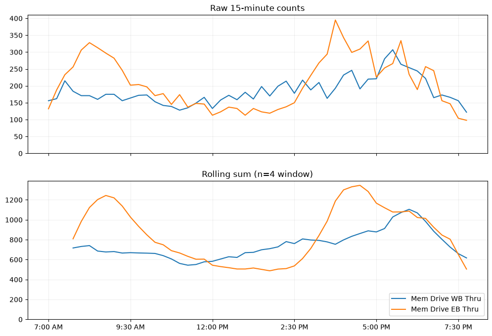
For example, looking at the eastbound volumes - the highest 15-minute count is 395 vehicles. Designing around this data point means the roadway will be built to support at least 395x4 = 1580 vehicles/hour. Yet the actual measured maximum hourly flow is 1346 vehicles/hour. In other words, this choice leads to roadway capacity being significantly overbuilt, in this case by at least 17%. This is incredibly wasteful, especially when that extra capacity is coming at the expense of other critical things like VRU safety and riverfront green space.
In any other discipline besides traffic engineering, taking a single data point from noisy data like this and treating it as representative/basing major design decisions upon it would be unacceptable. It also ignores the day-to-day variation in traffic patterns, as well as the fact that traffic is malleable: drivers can and will seek alternate routes if needed, or start their trips a bit earlier or later.
There are even arguments for going beyond peak hour and using a 24-hour capacity framework to truly understand the tradeoffs being made/whether space is being used efficiently.
Again, this decoupled approach of “traffic first, safety later” is not actually realistic and leads to bad outcomes. By designing the roadway around spikes in traffic, it will be heavily underutilized for the majority of the day, leading to dangerous speeding and all the safety issues that stem from that.
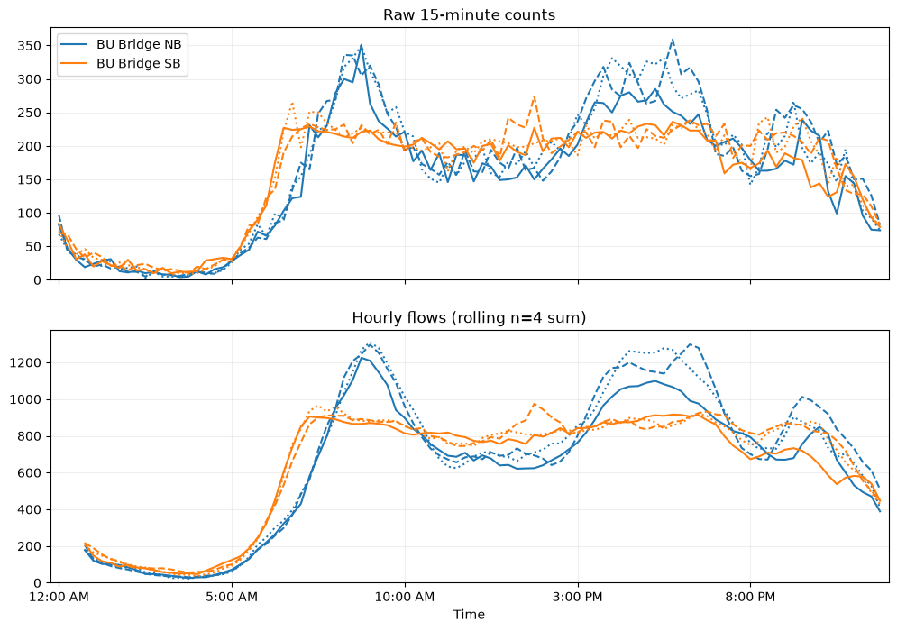
It also cannot be stressed enough that the real limiting factor for traffic is not this intersection, but rather the SB lane of the BU Bridge - the capacity of which is limited by the signals at the Boston side/Comm Ave end of the bridge as per this November 2024 analysis/presentation from local advocate Peter Furth, who is also a civil engineering professor at Northeastern and a traffic signals expert. If his proposals were implemented, the capacity could be slightly increased to 1,074 vph (vehicles per hour)4 - but that’s still not high enough to justify the size of these intersections. The bottleneck effect is still clearly visible in the most recent traffic count data, where the SB flows basically plateau at around 900 vehicles/hour all day, compared to the more peaky NB flows:
Not to mention, the Western Ave intersection acts as yet another downstream bottleneck for Mem Drive WB traffic. In light of these nearby bottlenecks, there is little benefit in padding the intersection capacity here. And the fact that MassDOT’s traffic analysis didn’t even account for neighboring intersections/bottlenecks (that’s reserved for the next stage of analysis) is a major flaw in the selection process which casts serious doubt on whether their final 2 design options really were the best ones.
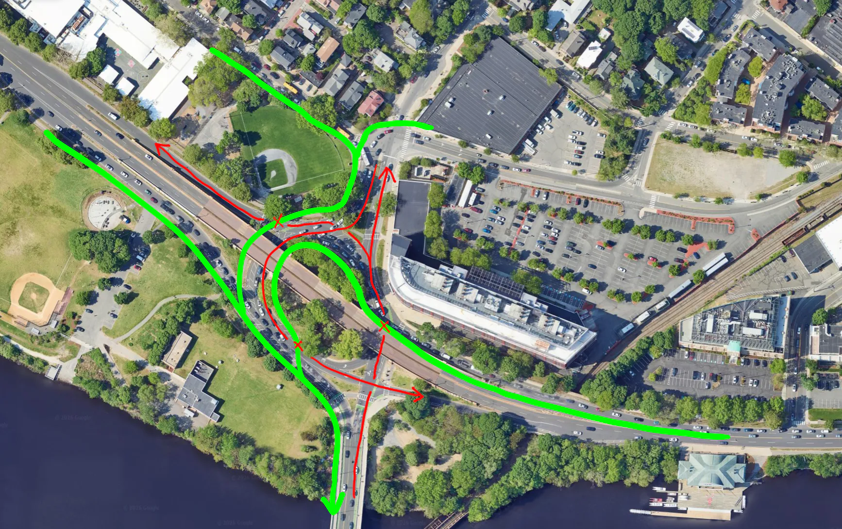
Rather than oversizing the intersection, the focus should instead be more efficiently routing traffic through here in a compact manner, rather than big intersection footprints that merely give the illusion of shorter queues/faster trips when everything is actually headed to the same 1-lane bottleneck anyways. And while some backups during peak periods are inevitable, the key is for queues to mainly form on Mem Drive, which is actually quite well-suited to handle them, as opposed to the current situation where queuing happens:
- in the middle of the intersection blocking other traffic movements, as in the current rotary, and as will happen when box-blocking inevitably occurs with MassDOT’s designs
- and/or in Cambridgeport clogging up neighborhood circulation
Rampant speeding remains unaddressed
Excessive speeds underpin most of the safety issues along Memorial Drive. Higher roadway speeds:
- reduce the rate of yielding to pedestrians
- increase the chances of a crash occurring in the first place
- correspond to crash severity when one does occur
Speeding was almost certainly a contributing factor behind the fatal September 2024 crash where a driver jumped the curb and killed a cyclist riding on the adjacent shared-use path.
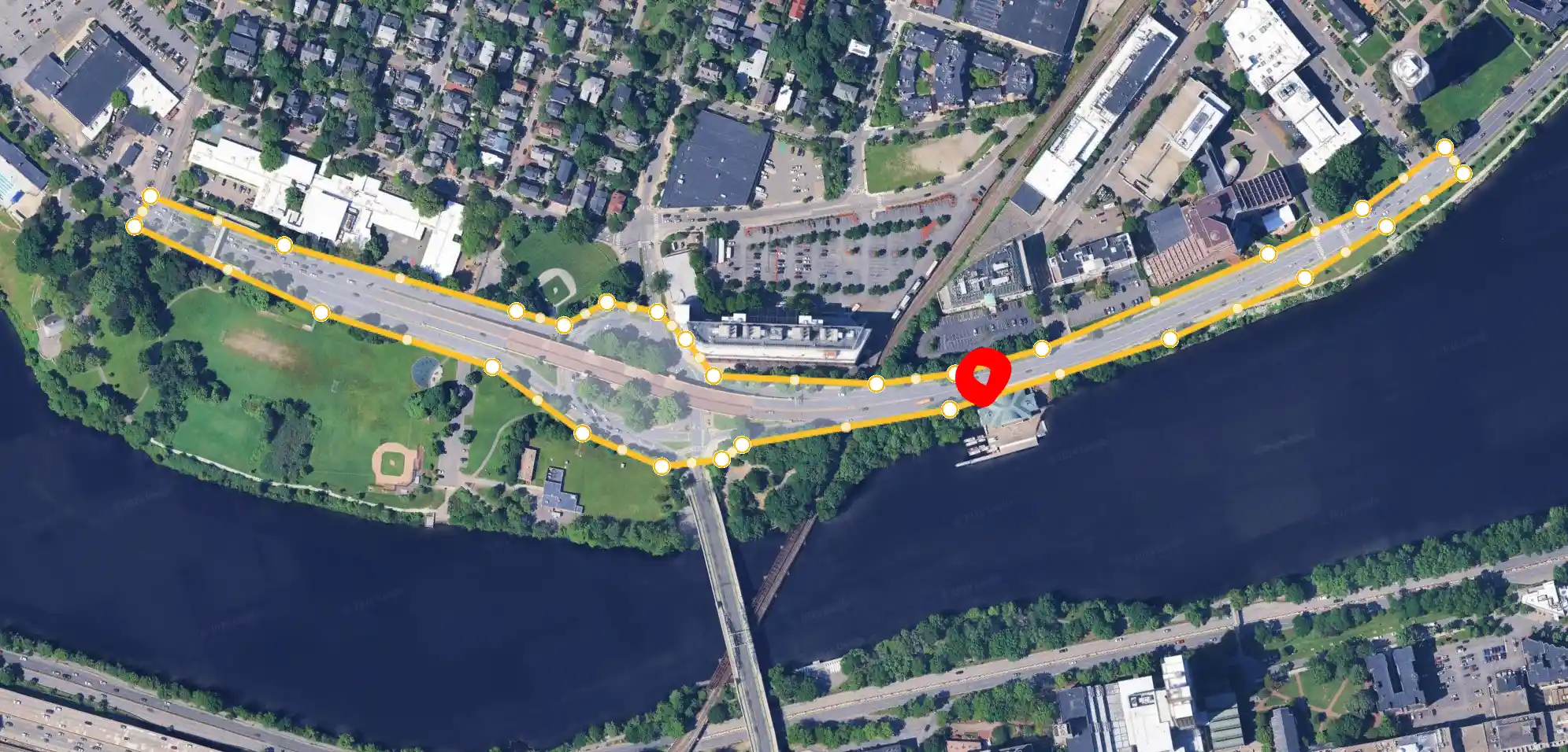
Below is the most recent speed data on Mem Drive by the BU Boathouse, which sits in a 25 mph zone located between Magazine St and Audrey St, while the rest of Mem Drive has a 35 mph speed limit.
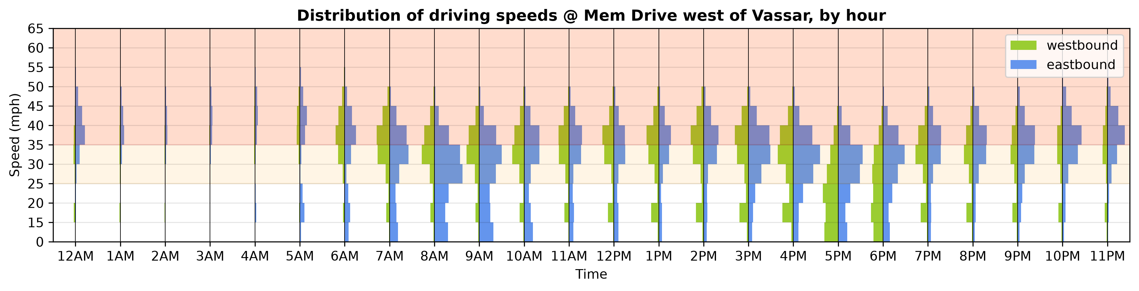
The data confirm what everyone already knows, which is that pretty much everyone on Memorial Drive is driving over the speed limit and that speed limit signs do nothing. Each weekday5 on average:
- 75% of cars were going over the 25 mph speed limit at the measurement location
- 38% of cars were going the 35 mph that is the speed limit on the rest of Mem Drive further from the rotary
- 1,124 cars were going 45 mph or faster
- 236 cars were going 50 mph or faster
- 48 cars were going 55 mph or faster
- 12 cars were going 60 mph or faster - it’s an indictment of the current road design that it is even physically possible for a driver to reach these speeds!
Cross-reference these speeds with the below table (data from IIHS) outlining the risk of serious injury or fatality for pedestrians struck by vehicles of different heights at various speeds:
| Vehicle speed | Median-height car | Median-height pickup |
|---|---|---|
| 20 mph | 16% | 27% |
| 25 mph | 25% | 52% |
| 30 mph | 37% | 75% |
| 35 mph | 52% | 91% |
| 40 mph | 66% | 97% |
| 45 mph | 78% | 99% |
| 50 mph | 86% | 100% |
| 55 mph | 92% | 100% |
| 60 mph | 95% | 100% |
Every day is a game of Russian roulette here. And in fact, these numbers actually understate the problem, because the only drivers NOT going over the speed limit are:
- WB cars coming out of a full red-light stop at the Amesbury traffic signal further downstream (the consistent green blip in the 15-20 mph range)
- EB cars slowing/stopping in the travel lane to take a left onto Vassar St (the blue distribution shifting downwards during rush hours) and/or queues from the Amesbury signal
- briefly, for maybe just ~2 hours of the afternoon, cars queueing in the WB (green) direction as rotary traffic heading for the BU Bridge backs up
Excluding these cases more truly reflects the speed that the current road design actually supports/encourages - which is way too high, with basically half of all traffic going over 35 mph.
The current situation is dangerous and unacceptable. Yet neither of MassDOT’s designs address this, as the roadway on either side of the main intersection are left exactly the same as they are today. Traffic calming is needed beyond just the main intersection itself (which seems to have drawn all the design attention so far).
The terrain worsens this problem
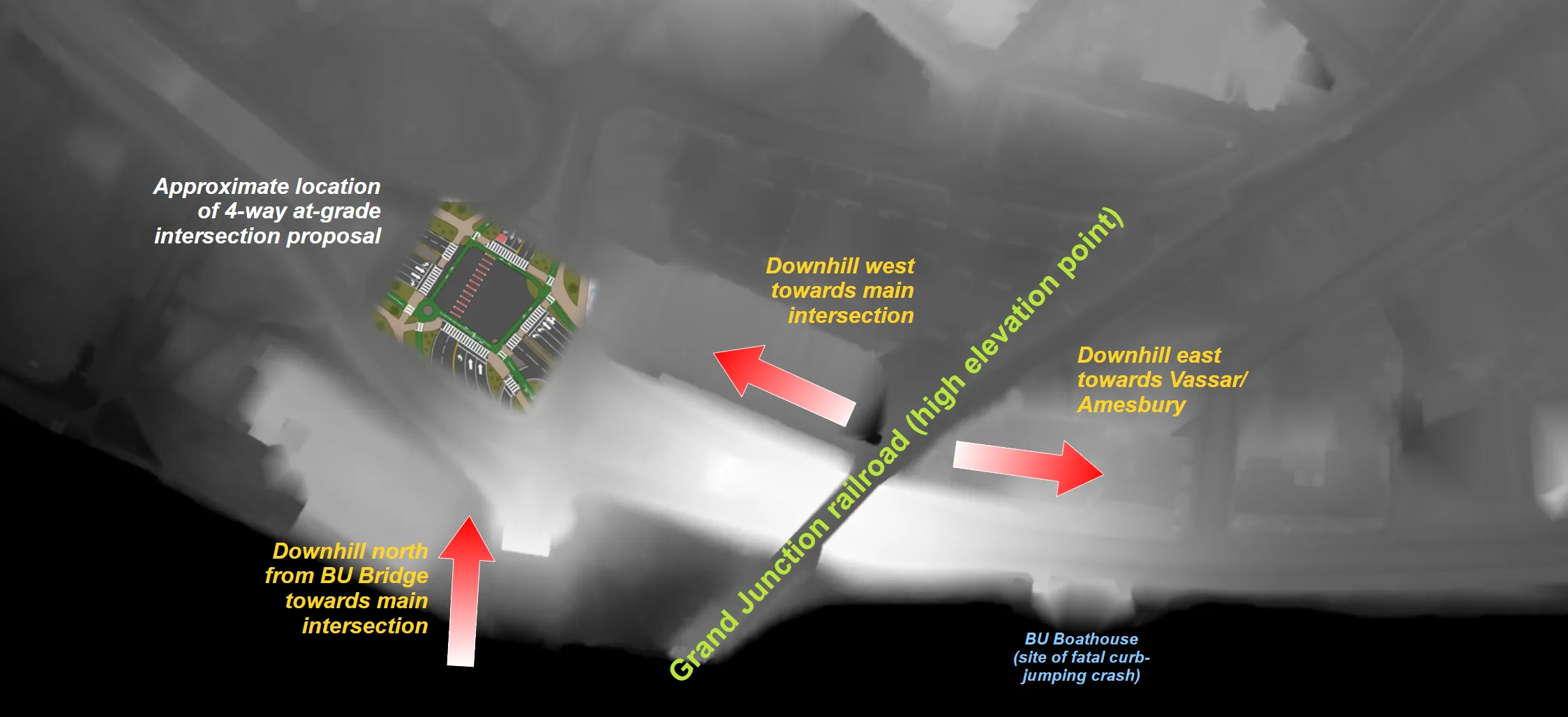
It’s not so obvious from the 2D plans, but there is a lot of hilliness within the project area. Of particular concern are the downhills in either direction from the high elevation point over the Grand Junction railroad tracks, around ~5% grade in terms of steepness and currently consisting of:
- 2 eastbound lanes downhill (out of a wide 4-lane cross section) towards the BU Boathouse, where the curb-jumping fatal crash occurred
- 1 westbound downhill lane in the opposite direction for the rotary on-ramp
Both the 4-way at-grade and TDI options preserve the eastbound configuration exactly as-is. In other words, these new designs would not have done anything to prevent the fatal crash by the BU Boathouse. The roadway remains 4 lanes wide, inducing speeding, and there is still little/no buffer between that high-speed roadway and the adjacent curb-level path.
And in fact, the 4-way at-grade design actually increases the risk, because instead of the current single eastbound downhill lane towards the main intersection, there will be 2 downhill lanes expanding to 4 (an extremely wide open roadway encouraging off-peak speeding)…all aimed towards the heavily used N-S crossing, which will be longer and more exposed in this design (6 lanes).
Other similar local examples, in case it helps people imagine how this would play out here (unfortunately the street view camera lens tends to understate slopes):
- McGrath coming down towards Pearl: https://maps.app.goo.gl/AKN7gZwpqvHfyWbG8
- McGrath coming off the Squires bridge: https://maps.app.goo.gl/hKDa2tenRo6y5XTd7
- Cambridge St Bridge in Allston: https://maps.app.goo.gl/6eChgSjq8HfCZzDj9
A road diet is crucial for safety
Unless MassDOT is willing to install a bunch of speed humps along the full length of Mem Drive, the only way to do something about the aforementioned rampant speeding is by managing the horizontal cross-sections of the roadway. I know this is going to get pushback, so let’s look at why this both necessary and feasible.
Still no crash analysis
In keeping with its “safety later” approach, MassDOT still has not presented any kind of crash analysis here. If they did, maybe they’d think twice about retaining the wide 4-lane downhill east of the intersection. Even a brief, informal examination of the data is troubling…looking east at just the short quarter-mile section between the overpass and Audrey St since 2015:
- 127 crashes in total, 36 of them injury crashes (28%) + 1 fatal crash (cyclist John Corcoran struck on the sidewalk in 2024)
- 35 of them rear-end crashes (23 of them involving EB cars) + 23 same-direction sideswipes - indicates a problem with turning cars having to stop in the middle of the travel lane
- 33 angle crashes at the 3 intersections of Vassar, Amesbury, Audrey - likely a byproduct of all the rushed, unprotected turns
- 10 head-on collisions + 5 opposing sideswipes - indicates need for a median buffer
- Independent of the above categories: overall, 4 drivers hit trees, 1 hit a fence, 3 hit light poles, 2 ran off the road - any of these could have been a repeat of the crash that killed John Corcoran had there been someone on the sidewalk/path at the time.
These statistics are not an indicator of a properly-functioning roadway. It is a well-established fact that 4-lane undivided highways like Memorial Drive are highly unsafe. But this problem has an equally well-known solution: a road diet! See this page from the FHWA (though the parent document appears to have been scrubbed by the current administration) on the many safety and operational benefits of converting a 4-lane highway to a 2-lane configuration with a center median for turns, especially the before-and-after conflict diagrams.
A dedicated left turn lane is needed for Vassar St at minimum
I was looking at the turning movement count data because I was curious about overall traffic flows to/from Cambridgeport, and the various contributions of the turning movements at the Pleasant, Magazine, and Brookline/Granite/Waverly intersections. Perhaps Cambridgeport residents might be able to draw some interesting conclusions from below graph.
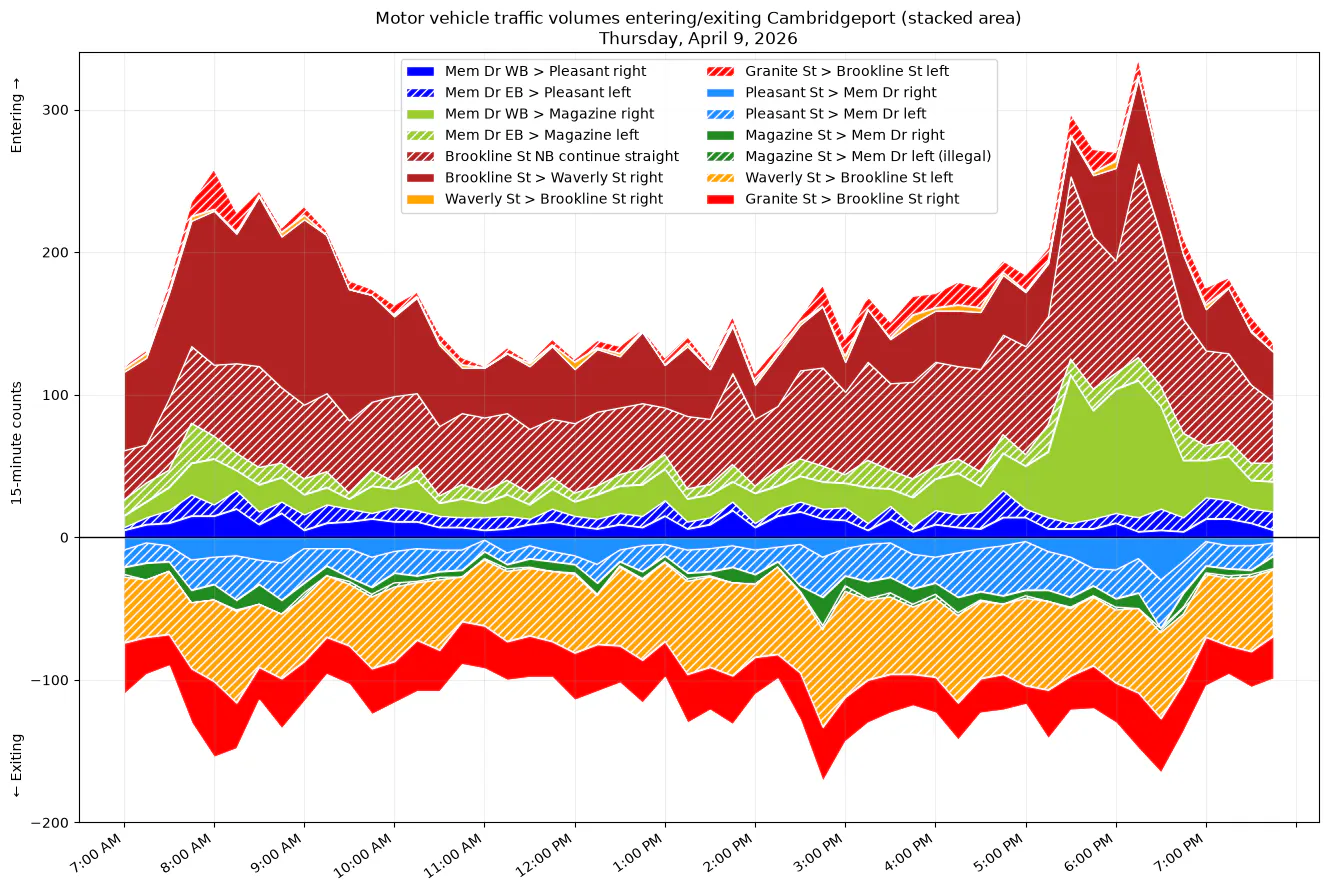
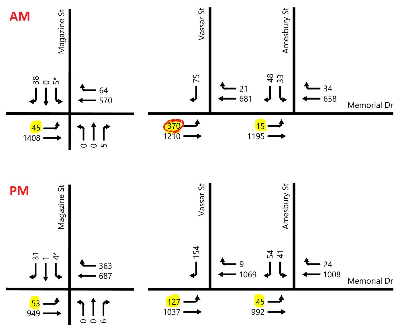
I was particularly struck by the asymmetry of how more cars were entering than exiting via these access points throughout the entire day, rather than flipping between the morning and evening. This made me wonder if flows were being balanced out elsewhere, especially if this traffic was primarily Kendall-bound commuters, so I made a similar plot for Area 2 (Vassar & Amesbury intersections). It does not seem like this is the case, with entering flows more dominant in the AM, and exiting flows more dominant in the PM. However, something else caught my eye: there is a very heavy flow of left turns onto Vassar St.
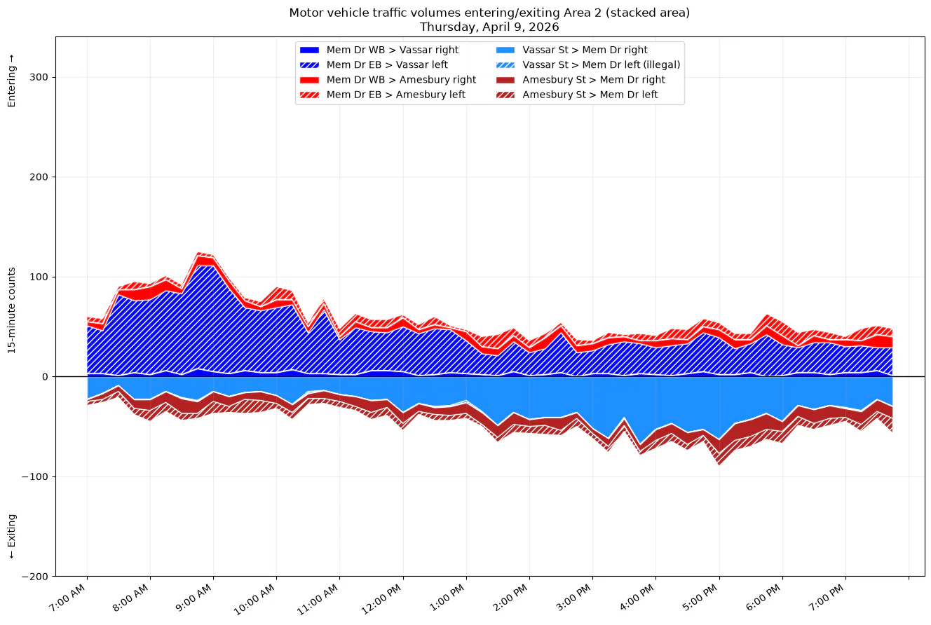
Specifically, the AM peak volume for this movement is 370 vph, which is on par with some of the heaviest movements in the primary project intersection. For comparison:
- Mem Dr EB > BU Bridge right turns: 325 vph
- Mem Dr WB > BU bridge left turns: 357 vph
Yet this left turn has no dedicated left turn lane, and instead cars stop in the middle of the high-speed travel lane! As mentioned above, you can actually see the effect of this in the eastbound speed data. And, it likely is responsible for many of the rear-end and sideswipe crashes in this stretch.
After stopping in the travel lane, these cars then need to make a turn across 2 lanes of high-speed oncoming traffic amounting to 681 vehicles/hour, plus a crosswalk. This is unsafe. Take a look at this video, at the 7:09 mark - 2 EB cars are stopped in the travel, waiting to take a left, but were initially hidden from view by the WB white car ahead of + one lane over from the dashcam driver. And note the jogger that was crossing Vassar, who was likely hidden from the view of the turning driver as well and therefore at risk of getting left-hooked. That turning car was probably under pressure to rush the turn given it was stopped in the travel lane, and needed to catch a gap in traffic - in a situation like this, most drivers aren’t even considering the possibility that there might be someone in the crosswalk (especially since VRUs could come from both directions).
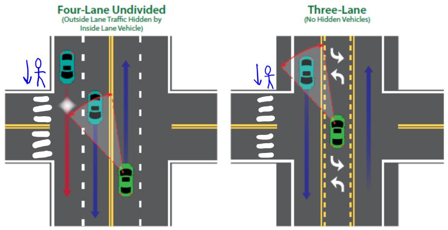
In light of all this, it is incredible that no dedicated left-turn lane is being added here. This 2013 NCHRP report provides the following warrants:
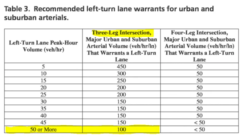
At 370 vph of left turns, and ~340 vph/lane of opposing traffic, conditions are well above the warrant threshold. In fact, all the intersections in the rest of the project area (River St, Pleasant St, Magazine St, and Amesbury St) meet the warrants as well, despite the lower left-turn volumes!
Not to mention, the cross-town 85 bus (formerly the CT2) uses Amesbury St in both directions. Having this bus stop in traffic then try to dart across 2-lanes of heavy high-speed traffic like this is also dangerous.
As part of this project, one of the 4 lanes of Mem Drive absolutely must be converted to a turn lane - meaning that in either the EB or WB direction, thru traffic must be reduced to 1 lane.
Reduction to 3 lanes is feasible outside of the main intersection
However, the lane reduction can go even one step further than that, to 1 thru lane each way + a center median. Below are the volumes of Mem Drive thru traffic during the AM peak hour (8:15-9:15) and the PM peak hour (5:30-6:30):
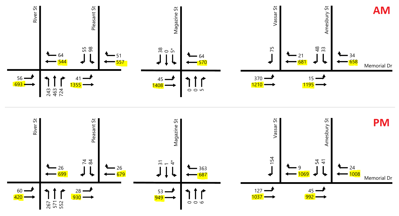
A single lane would be sufficient to handle these flows if they were continuous/uninterrupted. But it gets more complicated when there’s traffic signals along the way, particularly ones where the red for Mem Drive thru traffic is pretty long due to heavy cross traffic. This is why MassDOT’s 4-way design is so big yet difficult to reduce in size (as discussed in more detail later): Mem Drive thru traffic has the green for just 2 out of the 6 signal phases, so more lanes are needed to try and shove through as many cars as possible in that short window6.
However, the minor “satellite” signalized intersections of Pleasant St and Amesbury St are less of a problem, because the ratio of thru traffic to cross traffic means that Mem Drive can have a large enough proportion of the green time to support these flows!
For example, let’s look at the worst-case scenario: Pleasant St during the AM peak hour. Assuming an “ideal saturation flow rate” of ~1900 cars/hour/lane (as per this FHWA page) and giving Mem Drive 80% of the green time, that comes out to 1520 vph, which is higher than the measured 1355 vph. And the short 20% green time given to Pleasant St cars supports 380 vph, which is also sufficient compared to the measured 153 vph - not to mention, the availability of a center turn lane along Mem Drive might even reduce Pleasant St demand, as some drivers may no longer feel the need to use this signal to safely turn left when exiting the Micro Center shopping center.
Of course, this is just back-of-the-envelope math and there’s additional factors to consider like the dead time between signal phases, etc. The point is that a road diet is nowhere near as far-fetched as MassDOT/DCR act like it is.
It’s also important to note that Mem Drive EB basically already functions as 1 thru lane anyways, just with more cars weaving in and out. Cars going to various busy destinations along Mem Drive such as Trader Joe’s/Micro Center stop in the left-hand travel lane before making the turn into the shopping center, forcing thru traffic behind them to either also stop/wait, or merge to the right. Some examples:
- This recent May 2026 video - right at the beginning, the POV driver has to go around a car that is stopped to turn into the shopping center. Then shortly afterwards, you see a car attempting to turn left out of the Shell gas station, but it has to stop (blocking both WB travel lanes) because it misjudged how fast the EB traffic was approaching
- This video from 1984 showing that this definitely is not a new problem - near the end of the video at 2:07, there’s a close call as a car swerves into the right lane to get around cars stopped to take a left at Amesbury
In other words, formalizing an actual turn lane won’t hurt traffic, it’ll simply allow drivers to make the movements they need to without a big unnecessary helping of crash risk.
In between Magazine St and Vassar St, where there aren’t any more cross streets needing a dedicated left turn lane as the BU Bridge intersection approaches, the center median can instead become a 2nd thru lane to organize traffic as it splits up to either continue straight along Memorial Drive, or to one of the turn lanes. And though this is outside the project area, the same can be done west of Pleasant St, with the center median becoming a 2nd WB lane that is functionally an extended left turn lane for westbound cars eventually making a left onto the Western Ave bridge.
If speeds in the project area are well-controlled around 25 mph (which they should be, though whether MassDOT will actually commit to that is unclear), only ~100-150ft is needed for a merge. There is room to do this in both of MassDOT’s designs.
Going beyond “won’t preclude”
Whenever advocates have asked about a road diet, MassDOT’s response is always along the lines of “we will not do anything that precludes a road diet.”
For several months now, sections of Mem Drive on either side of the BU Bridge intersection have been temporarily reduced to one lane each way due to construction work for the Eversource GCEP project (and this will continue for several more months going forward), installing duct banks for a transmission line that will run under Memorial Drive from Ames St all the way to Magazine Beach. You can actually see it in this Google street view:
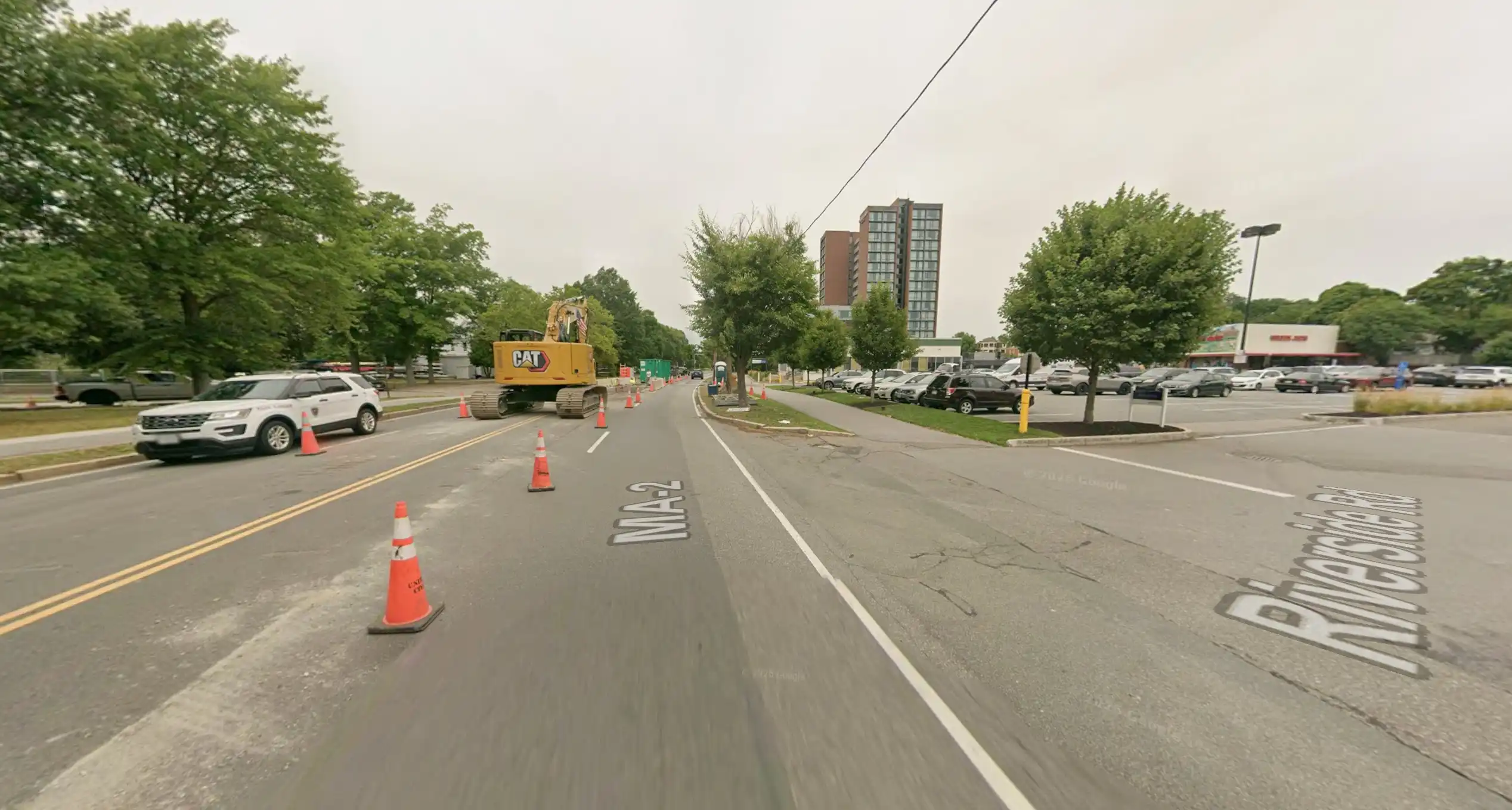
Yet this has not led to a traffic apocalypse! This is real-life evidence that Memorial Drive can function just fine despite a lane reduction. We have proof that this is possible today.
I understand that a broader road diet of Mem Drive is beyond the scope of this project. But rather than simply “won’t preclude”, this project should actually actively “precipitate/prompt/pave the way for” that future road diet, via implementing lane reduction(s) within the project area. At the absolute bare minimum, there should be lane reductions on the BU boathouse side to 1 way each way with a center median for turns/emergency vehicles.
As was mentioned during the advocates’ meeting, Cambridge DOT and DCR have said that they are on board with this. MassDOT can and should use this project as an opportunity to spur that effort. There are too many cases where the multi-jurisdictional nature of a project just means it spins its wheels while different agencies all point to each other as a reason they can’t take action. Enough with the stalling, let’s take that first step!
Any overpass MUST also have ped/bike facilities on it
This was one of the key features of AltC, yet was not acknowledged at all in MassDOT’s response.
If MassDOT is going to spend significant funds and effort to rebuild the overpass, enabling Memorial Drive thru traffic to skip over the messy intersection and avoid delays, that benefit must be extended to everyone, not just drivers. The current TDI design gives cars a shiny, brand-new overpass while pedestrians, cyclists, and other river path users making the exact same trip are faced with long waits/120 second signal cycles and are put in conflict with cars, made to cross 5 traffic lanes all while hoping that:
- drivers in 2 separate lanes reliably obey “no right turn on red” rules (extremely unlikely)
- the crosswalk isn’t already blocked to start with cars from the previous signal phase (heavy left turn from Mem Drive WB onto the BU Bridge, hitting that SB bottleneck and backing up/blocking the box)
- no one blatantly runs a different red light for any of the other movements
This glaring disparity/imbalance in what accommodations and investments are being made for each mode is an indictment of MassDOT’s actual priorities vs. stated values.
Again, the AltC design as well as Ari Ofsevit’s Hybrid Concept both call for overpass paths. But such a path can be integrated into MassDOT’s TDI option as well (an example of how this could be done is shown later). This would make the river path loop feel much closer to a true off-street, car-free recreational experience and also reduce conflicts between N-S and E-W cyclists, as most E-W cyclists could just take the overpass instead.
Better at-grade crossings
Geometry
Traffic signals are only the first line of defense, and often violated. MassDOT needs to seriously consider what can be done to mitigate harm in the inevitable situation where someone runs a red and 2 different road users end up on a collision course - especially if one of them is a VRU like a cyclist. Even if a protected intersection design isn’t exactly implemented, please follow those same underlying principles. Set crossings further back to improve visibility and so that everyone involved has more time to react if something goes wrong.
Organize traffic flows so that everyone’s movements are clear and predictable, defined well in advance. At the existing rotary, the fact that cars in the right-most lane coming off the BU Bridge can go either straight or right creates ambiguity that results in a right-hook risk for bikes. The dedicated right turn lane in the TDI option is helpful for this; the one in the 4-way is somewhat helpful but is rather short (in terms of distance between the crossing and where the right turn lane splits off) if you account for the speeds coming off the BU Bridge downhill, meaning less time to react for a given distance.
Again, speed underpins most safety issues. Harden turns as much as possible to slow vehicles down, and actually go a step further and deploy speed reduction measures on any approach to a crossing/turn as well. Have key crossings be raised crossings, or if that’s not possible, deploy speed humps in advance of the crossing.
Shorter distance and wait times for crossings
This section is primarily directed towards the 4-way at-grade design, where the crossing distances/intersection size is the largest, but may have some relevance to the TDI as well. Again, the 4-way design has a 5x6-lane intersection box that becomes (5-6)x(6-7) lanes from the perspective of people crossing. This is huge. Here is a street view showing a 6-lane crossing with some pedestrians in it for scale:
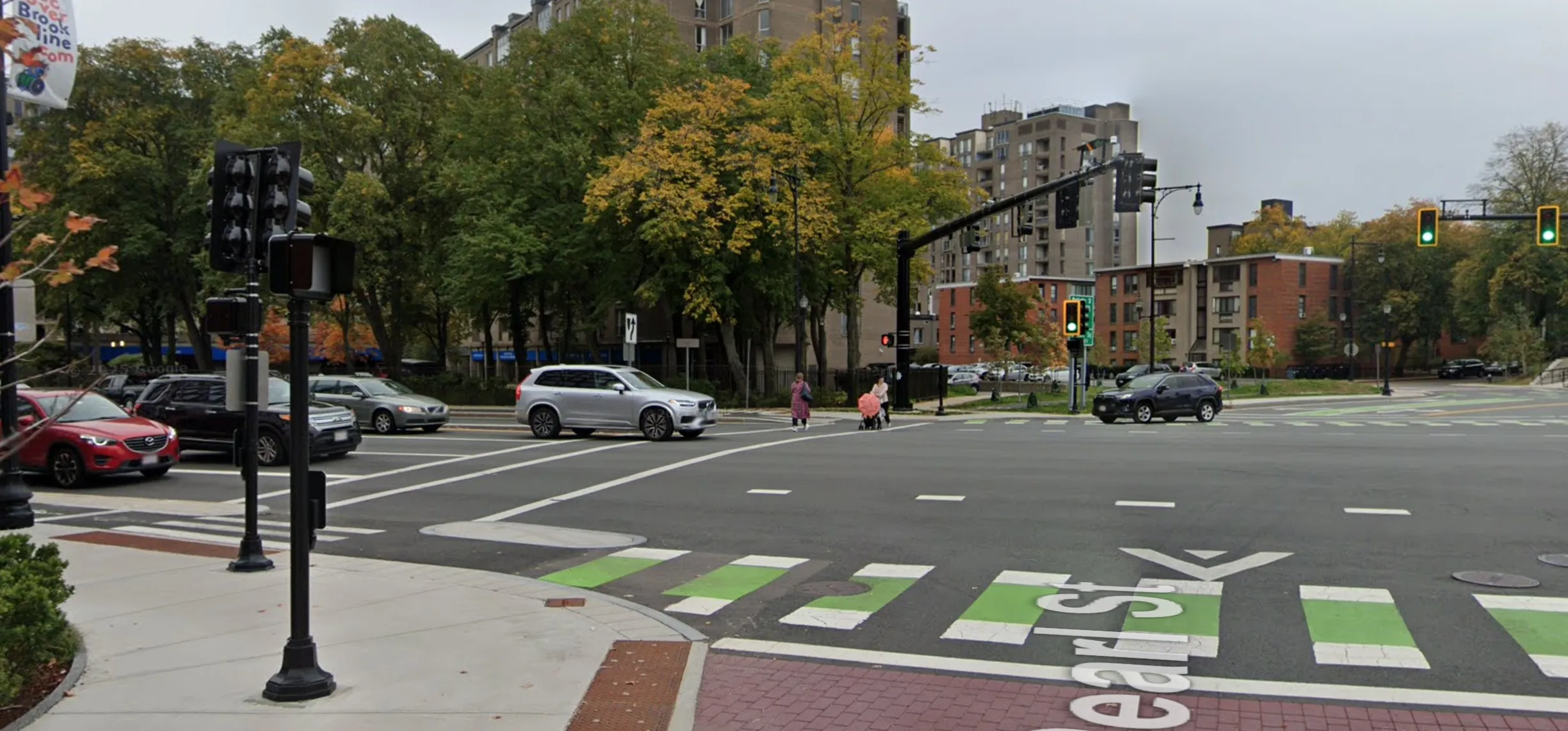
Some other points of comparison in the same size ballpark:
- Standing at the intersection corner by the Morse School field and looking across 6 lanes of Memorial Drive towards Magazine Beach/the river might look something like this street view from Charles St, looking across 6 lanes of Storrow Drive towards Lederman Park/the river.
- This is the reality of the “open vista river opportunity” that MassDOT advertises for the 4-way option.
- If anything, an overpass path could have a vista point at the high point that would actually provide views of the river. You can barely see the water from ground level.
- (4-5)x(6-7) lanes: South St & Arborway, by the Arnold Arboretum/Forest Hills T station, and a potentially very similar situation to this project (an overpass was converted to at-grade facilities)
- Here’s a video showing the POV of someone outside a car.
- 5x6 lanes: Chelsea St x New Rutherford Ave (at the Charlestown end of the Bill Russell Bridge)
- (4-5)x6 lanes: Mass Ave & Mystic St in Arlington Center - Minuteman users should be familiar with this one
- (5-7)x(6-7) lanes: Land Blvd & Gilmore Bridge/Rt 28
- (4-5)x4 lanes: Broadway & Galileo Galilei/Binney
Looking through these, none are layouts I would want to see replicated by the riverfront.
So, is there a way to make things a little bit smaller at least? Looking at the traffic data, there are a few candidates for lane reductions.
While Mem Dr EB thru volumes are too heavy for a reduction from 2 lanes, WB volumes could likely be handled by a single thru lane at the intersection. It’s not 100% certain since exact signal timings haven’t been provided yet, but 855 vph at peak seems doable for 1 lane. Not to mention, the volumes only get that high for 1-2 hours of the entire day. Again, when the cost of oversizing for brief peaks means more dangerous off-peak speeding, longer crossings/more VRU exposure, and less greenspace, it should be very carefully considered. Having queues on Mem Drive sometimes is not the end of the world.
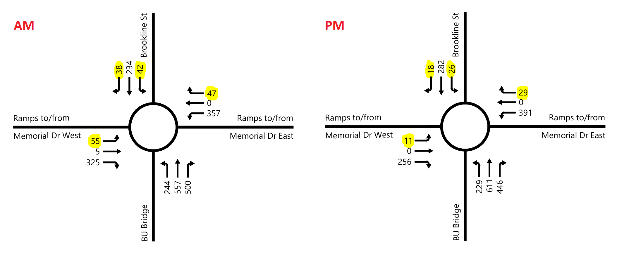
In addition, the left turn from Mem Drive EB > Brookline St is very low volume - just 55 vph at peak, yet it’s given a dedicated turn lane. It could easily be eliminated and its functionality (literally less than 1 car per minute) replaced by an unsignalized left turn lane at Magazine St instead. Of course, this idea should get run by Cambridgeport residents, but I can’t think of any trips that this particular turn facilitates that could not also be done with just a minor detour.
Not only would this shorten the crossing by 1 lane’s width, it would also enable the north and west crosswalks to be active during phase 1 of the 4-way design’s traffic cycle, reducing pedestrian wait times/increasing time to cross. The same could technically be done for the TDI, though since this movement coincides with the lone phase where river path users can cross, it wouldn’t really help simplify/shorten the signal cycle.
The Mem Dr WB > Brookline St right turn is also low-volume. In the at-grade option, this has already been combined with the thru lane, but maybe the right turn lane could be dropped from the TDI as well. This is pretty minor though.
Finally, since the state apparently does control the Brookline/Granite/Waverly signal, I wonder if altering the layout of that intersection is also within the project scope as it could definitely benefit from some shrinking. The N-S crossing of Waverly St is 65 ft long, which is excessive given it’s technically to cross only 3 lanes:
- Get rid of the existing large truck apron and instead set back the Waverly stop line/assume that the occasional oversized vehicle will take an extra-wide turn as needed.
- Eliminate Waverly > Brookline right turns as that is very low-volume (10 vehicles/hour at peak) and can be easily rerouted via Henry St.
- With that, reduce Waverly St WB to just 1 lane. That 2nd turn lane only adds 5-6 vehicles worth of extra storage and really only creates extra chaos, given most of those cars are headed to the same 1-lane bottleneck and need to merge again very soon.
Shrinking the intersection would also reduce the severity of the box-blocking behavior that regularly occurs here. Even if box-blocking happens, it’ll be just be 2-3 cars rather than a dozen and clear out more quickly. This could also facilitate faster signal cycles since less time is needed for the shortened pedestrian crossing.
Overpass width/speeds
Also related to the speeding issue: on the TDI plan diagram, where the cross section of the overpass is shown, MassDOT notes the following:
10’ travel lanes with 2-4’ shoulders (waiver required), 12’ travel lanes with 2-4’ shoulders (preferred).
That “preferred” layout would mean the proposed 2-lane overpass ends up being nearly as wide as the 4-lane overpass that exists today. MassDOT insists the “preferred” layout is due to needing to follow FHWA regulations as this project is receiving federal funding, and said anything less would require a waiver that there’s no guarantee of receiving.
As advocates have repeatedly pointed out:
- Memorial Drive is a parkway, not a highway.
- Large trucks are already prohibited.
- The speed limit in the intersection area is 25 mph.
There is absolutely NO reason for wide 12’ travel lanes, which will only encourage speeding. In addition, having 2 lanes on the bridge means that the 2nd lane can be used for passing in the rare emergency situation, eliminating the need for wide shoulders. Saying “we’re getting highway agency money so we have no choice but to design this like a highway” is not acceptable - rather than a noncommittal “we’ll look into a waiver,” MassDOT should be actively be putting together the strongest possible case for a design exception here.
Direct quote from FHWA guidance on design exceptions (highlights mine):
While FHWA-approved standards apply to all projects on the NHS, we encourage flexibility and a context-sensitive approach which considers the full range of project needs and the impacts to the community and natural and human environment. Design exceptions are a useful tool that may be employed to achieve a balance of project needs and community values.
The community itself has been very clear that a highway-style design is totally inappropriate here. What is less clear is whether MassDOT internally agrees.
Finally, in the worst case scenario that MassDOT insists on wide shoulders, they first need to commit to speed control measures like flexposts or rumble strips/bumps in the shoulder - and it has to be something that’s permanently built in/can’t be removed or backtracked on later by citing operations issues (e.g. snow plowing).
Transit
Inadequate bus queue jump
I appreciate that MassDOT is finally taking steps to address the severe transit delay around this intersection, by adding a bus queue jump for the inbound 47. However, that bus lane needs to extend much further back to have any actual benefit, probably up Granite St until Pearl St at least. The current neighborhood traffic circulation layout means that access to that bus lane will likely be cut off by a long queue on Granite St, as well as cars coming from Waverly St and blocking the box.
Again, take a 360-degree look around this street view, which shows backups that will still exist during peak hours with MassDOT’s designs, as per the project team’s own admission. Note that the right-turn lane from Granite to Brookline is completely empty, because access to it is cut off by the cars waiting to go in the other direction. The same thing would happen with a bus lane that only starts after the Granite St exit. Please keep that street view in mind and think through how a bus lane would actually function here.
Please implement TSP
Whatever the final intersection configuration ends up being, the signals should be capable of transit signal priority to help both the 47 and 85 (formerly CT2) key bus routes which pass through here. This is even more important since it seems unlikely there will be room for bus lanes/queue jumps for the outbound trips of the 47/85, as well as for the inbound 85 as it approaches the intersection via Mem Drive WB.
Confirming Grand Junction future-proofing
It is critical that the new Grand Junction bridge height & width is sufficient for:
- Future electrified transit service
- Ari Ofsevit’s writeup has more specific suggestions regarding the future transit needs
- The April plans have written “18.5’ min clearance” for the Grand Junction (August plans are not hi-res enough to be legible, but assuming it’s the same), which is a slight increase over the existing vertical clearance of 16’2” - but that still seems on the lower end? But others more knowledgeable about trains can weigh in.
- An extension of the long-planned Grand Junction Multi-Use path
- See this sketch I made previously showing how these connections could link the existing paths on both sides of the river, as well as to the new protected bike lanes on Vassar St
- The absolute bare minimum should be a 10’ shared-use path connection on the west side, as that aligns with current Grand Junction path plans. However, the ideal would be 14’ wide path(s) as this would likely be extremely heavily used, given river crossings that are bike-friendly are few and far between.
- In addition, a 2nd path on the east side would allow a direct connection between the Vassar St cycle track and the river crossing. It’s also better situated to continue the connection to cross Storrow Drive and connect with BU, without requiring a new under-bridge tunnel like the west-side path would. Currently, there are no bike-accessible connections across Storrow Drive for a full 1.5 miles, between River St and the Silber Way footbridge (there’s only a pedestrian stairway near the BU Beach).
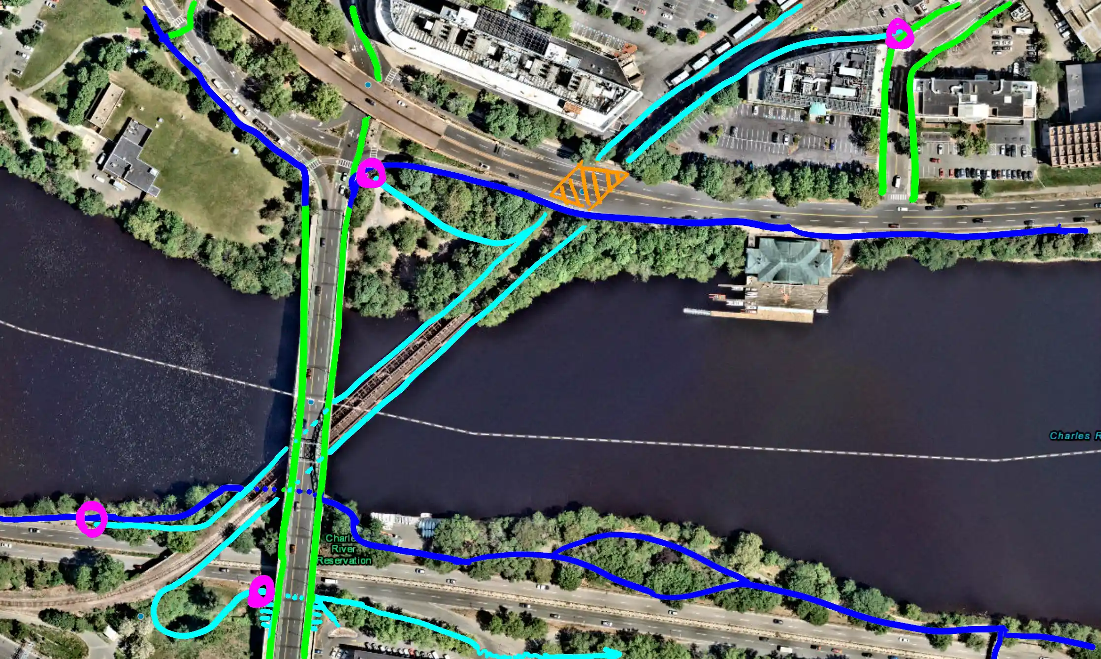
Please share actual specific dimensions with advocates, rather than just getting a checkoff from some person at the MBTA - the MBTA isn’t always on top of future planning either, I’ve found. Again, this is a once-in-a-lifetime opportunity for addressing a critical/major gap in both transit and ped/bike connectivity, facilitating mode shift and serving far more people than expanding any of the existing roadways could do. Let’s not be penny-wise and pound-foolish.
Other notes
This section is a bit of a catch-all for stuff that can likely be hashed out later in the design process rather than being critical for selecting a concept to move forward with - but still noting it here so it does not get lost.
- The revisions so far have made improvements in terms of reducing roadway footprint/impermeable surface area and increasing riverfront area, but needs to go further. Additional lane reductions (as discussed above) and additional geometry adjustments (see below example of how this could be done for the TDI) should still be considered across all designs.
- Peter Furth mentioned adjusting the grades so that the climb to the BU Bridge is not so steep - he noted that the Dutch use a maximum 3% sustained grade on bridge approaches for cyclist comfort. I heartily second this suggestion as someone who struggles with that climb when I’m tired (sometimes I even dismount and use the sidewalk).
- More thought needs to be given to bike routings and potential conflicts between E/W and N/S bike traffic. In particular, I know the bike roundabouts came from an advocate suggestion during the workshop, but again we’re not a monolith and I do not feel that these are appropriate or beneficial here (even though I’m arguing for a roundabout for the main intersection, funnily enough). Also, some of them are alarmingly close to the corner/curb. The better approach for managing conflicts is clearly-marked, well-positioned, sufficiently-spacious waiting areas, together with smart signal phasing.
- Think about broader bike connectivity - someone else brought up having a 2-way bike path segment on the north side to the Trader Joe’s/Micro Center lot so people don’t have to use the Magazine St footbridge. And as mentioned above, please keep future cross-river connections in mind.
Comments on specific designs (including advocate alternatives)
Regarding the “at-grade option as a stepping stone” strategy
It seems more people are leaning towards the TDI, but there’s definitely some who are strongly opposed to any overpass whatsoever. The below comment regarding the lone overpass option at the April advocate’s workshop captures this sentiment in a nutshell:
This design [referring to the TDI] cannot be retrofitted for a multimodal, transit-oriented sustainable future. We will be stuck with car dependency and induced demand for 50+ years.
The argument essentially boils down to “it has to get worse before it can get better”: even though taking down the overpass means we’ll get a huge at-grade intersection for now, which isn’t great, an at-grade intersection is at least easier to reconfigure compared to an overpass that would likely last for close to a century if properly built. Therefore, an at-grade intersection would be more amenable to a future road diet.
However, I believe that this is a really unrealistic approach because it relies on MassDOT being willing to slash traffic capacity to just 25% of today:
- removing the overpass already halves the capacity because Mem Dr thru traffic now needs to stop for cross traffic/sit at a red light for ~half the time
- then a “future road diet” implementing Mem Dr thru lane reduction from 4 > 2 will halve the capacity again
A 50% reduction is possible as Memorial Drive currently is oversized for the amount of traffic it carries, which is exactly why this writeup pushes for a reduction to 2 thru lanes above. But a 25% reduction is something MassDOT will never, ever do in any of our lifetimes, because they would only consider such a change if traffic volumes dropped to well under 25% of Memorial Drive’s current capacity7 - which will never happen on its own. Once a massive at-grade intersection gets built, that is what we’ll be stuck with permanently.
It’s true that there are plenty of cases where overpasses are bad highway-style infrastructure. But if an overpass is narrow and also has a ped/bike path on it, and will not actually create any extra burden for path users due to the existing terrain (more on that here), then it can be a good thing. And regarding the concern about an overpass inducing demand/speeding: at least in the case of the Alternative C design, the crossovers create new stopping points for thru traffic so that it’s not a total free-flow situation. And an overpass does not preclude a broader road diet of Mem Drive; in fact, the AltC sketch shows a 3-lane configuration (2 thru lanes, 1 center turn lane) of Mem Drive on either side of the BU Bridge.
Even in the absolute best-case scenario where MassDOT miraculously agreed to have 1 Mem Drive thru lane in each direction at this intersection, we’re looking at a 4x4 intersection, maybe 4x3 lanes if some lower-volume turn movements were combined with the thru movement. This is on par with the 4x3 Western/River intersections. This doesn’t seem like enough of a benefit to be worth dealing with 6/7-lane crossings for a few decades in the “short” term - I would much rather push for the smallest possible footprint right from the start instead.
A new advocate proposal: the “Hybrid Concept”
The “Reid Overpass Hybrid Concept” is a relatively recent concept that was put forward by local advocate Ari Ofsevit about a week after the August 6 open house. His full writeup of the proposal can be found at https://docs.google.com/document/d/1aA7oSgTyHzi7K_atobhzvPIZl3W03-BMfekmPFPRAiw/edit?tab=t.0
It’s definitely better than either of MassDOT’s options as they currently stand, and is a nice upgrade that seems within reach, a.k.a. not too unusual or complex for MassDOT’s tastes (the author even points to several precedents in the area). However, I still have some reservations:
- Even though it’s technically 1 lane for EB traffic only, MassDOT will certainly require enough width for a vehicle to pass, e.g. emergency response, or if a vehicle breaks down while on the overpass. In other words, there will have to be a wide shoulder that essentially doubles the overpass MV lane width. Whereas a 2-lane overpass as in the TDI or AltC designs doesn’t need large shoulders because the oncoming lane could be used for passing in emergency situations. This would promote speeding on the overpass, so there would need to be a commitment from MassDOT to implement speed reduction measures, like speed bumps in the shoulder area.
- The footprint is still fairly large: take the Western/River 4x3-lane intersections, slightly upsize them to 5x4 lanes, and then put an additional overpass structure next to it carrying a wide additional travel lane. I feel like if we’re going to rebuild an overpass, we should be able to get much more benefit in return when it comes to reducing the size of the at-grade components. Right now, the overall roadway footprint is roughly similar to MassDOT’s options (see the comparison table from earlier).
- While E-W river path users can use the ped/bike lane on overpass, the N>S crossing is 4 lanes while the S>N crossing is 5 lanes. And for the latter, it is a similar configuration to MassDOT’s design: a 2-stage crossing with a sliplane-like geometry that is 100% reliant on signal compliance to be safe. As discussed previously, this is risky.
Overall, I see the primary benefit of this design over MassDOT’s as being better traffic operations from taking one of the heaviest traffic movements (Mem Drive thru EB) out of the intersection. The main ped/bike benefit is the crossing-free river path overpass routing, but otherwise the number of lanes to cross, while fewer than MassDOT’s at-grade option, is still an increase over the existing conditions and over MassDOT’s TDI option (as well as AltC).
That being said, I am a big fan of the transit components of this proposal - those can and should be added into any other proposal as well! And making the Grand Junction extension an early-action item is a great idea that I hope the project team considers when considering construction phasing.
Improvements to the TDI
Again, neither of MassDOT’s options are satisfactory, but if forced to choose I would opt for the TDI over the 4-way. In the event that MassDOT ends up proceeding with the TDI option, there’s some changes that could make it a little better. Below is a very rough sketch of a revised TDI design, with the unmodified MassDOT design next to it for comparison.
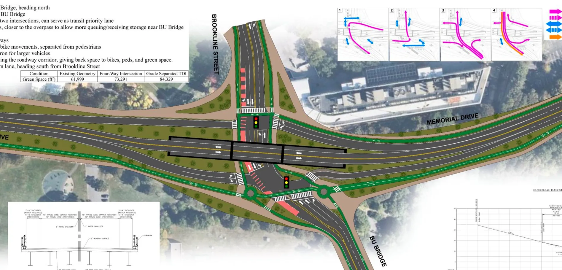
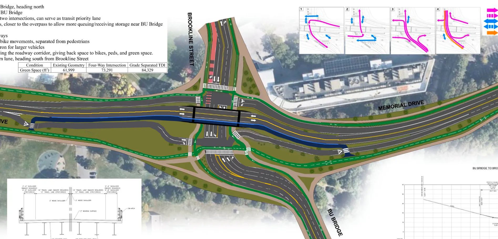
Despite the name, a TDI doesn’t need to be diamond-shaped; in fact, all the other nearby TDI examples mentioned previously have the on/off ramps essentially be parallel to the overpass. The only limitation on how much you can flatten the diamond is the need for some minimum distance/spacing between the 2 traffic signals.
So what the proposed revisions to the TDI do is to make the north-side ramps run right alongside the overpass (similar to the original January design), and on the south side, have the ramps stick close to the overpass for most of the way, but flare out approaching the intersection to provide that minimum signal spacing. This reduces the amount of wasted space in the median, and also adds curvature to the ramps that help moderate vehicle speeds before they reach the ped/bike crossings.
In addition, the overall intersection is shifted as far north as possible (as in the 4-way and AltC designs), increasing the amount of contiguous riverfront green space and lengthening the approach to the BU Bridge, accommodating a longer merge in the southbound direction.
This shift also buys room to tighten the southern intersection box, and in particular to square up the skewed southern crosswalk, shortening it. The extremely shallow >120° angle in MassDOT’s design would allow fast turns for the very high-volume Mem Drive EB > BU Bridge right turn movement, which is a safety issue for people using those 2 crosswalks, so making that corner more of a right angle is important. Note that things are squished pretty aggressively in the sketch, but again I’m just making suggestions here - the people with access to fancy CAD tools for drawing road layouts can figure out how to make things meet the necessary geometric standards/regulations.
And as discussed above, a ped/bike path is added to the overpass. While not as nice as the 100% car free overpass path routings in the Hybrid Concept or AltC, 2 short 1-lane crossings worrying about only 1 vehicle movement at a time is still way better than having to cross 5 lanes where you have to worry about multiple potential conflicts (I would be especially wary of the 2 right turns, with cars violating the NTOR restriction) and also have to wait a long time given the 120s signal cycle. If MassDOT does the right thing and takes real steps to reduce speeds to 25 mph in the project area (so not just more useless speed limit signs), then these crossings will be straightforward to navigate. But they could be made fully raised and further reinforced with RRFBs for extra visibility.
Finally, the sketch incorporates some suggestions that Peter Furth raised during the Zoom meeting a month ago for improving the traffic performance. Basically, the bus queue jump does not really provide much benefit past the first signal, so you can get 2 southbound thru lanes, and extend that to some of the turn lanes feeding into it. Perhaps this could help shorten the cycle length (the team said it’s currently 120 seconds) and reduce how long people have to wait for crossings.
Revisiting Alternative C
Though the previous writeup/pitch for Alternative C8 was shared with MassDOT in April, they did not comment on it until August (2 days before the open house, so after the final decisions had definitely been made already). And their response dismissed AltC for reasons that felt tangential, while the actual key points seemed like they were missed or misunderstood. I wish MassDOT had reached out with their concerns earlier so that I could’ve had a chance to clarify/defend the proposal or update the design in response.
If I had to try to summarize MassDOT’s main objection, it was that the AltC design was too “complex.” This was partly my fault for burying the lede9 as the original writeup tried to address a ton of different problems, some of which MassDOT considers beyond the scope of this project, such as:
- rerouting of the inbound 47 bus to a bus-only left turn on Magazine St to bypass rotary traffic
- Cambridgeport street directionality changes to address how a chunk of the neighborhood gets funneled towards backed-up rotary traffic on Granite St with no escape, even if their destination doesn’t involve the rotary at all - according to this article, some neighbors have started a petition about this issue
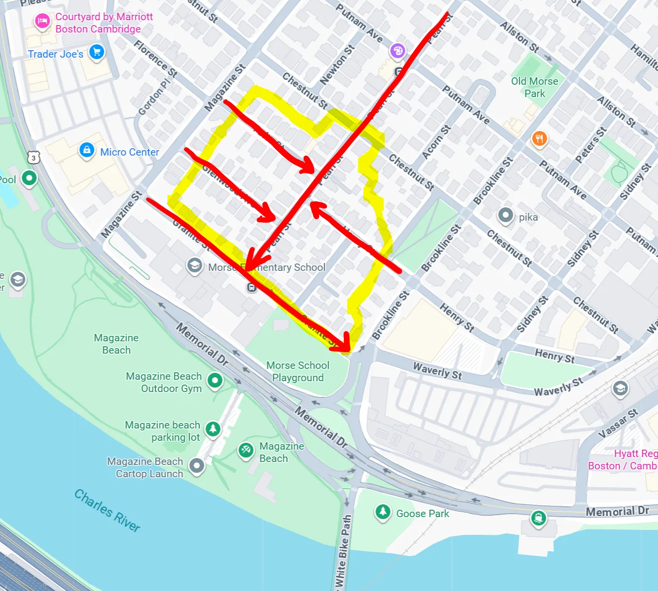
But because I didn’t make it clear which things were the core components necessary for AltC to function vs. the “bonus” features, I think the whole thing came off as too complicated.
I have updated/simplified the AltC sketch a bit (the original can be viewed here, the specific changes are described later) and will try to explain things more clearly this time, because it actually is not complicated at all. In addition, an analysis using the latest traffic count data further bolsters the feasibility of AltC.
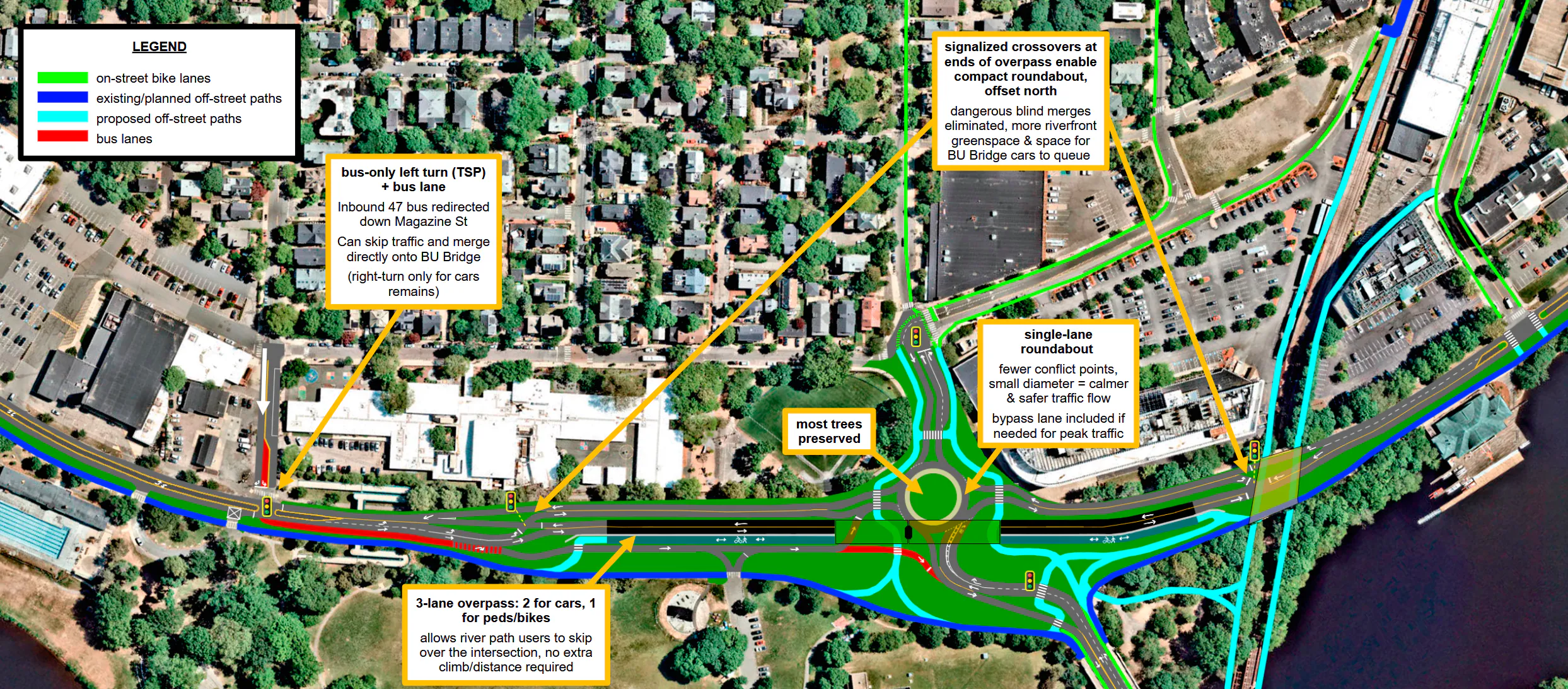
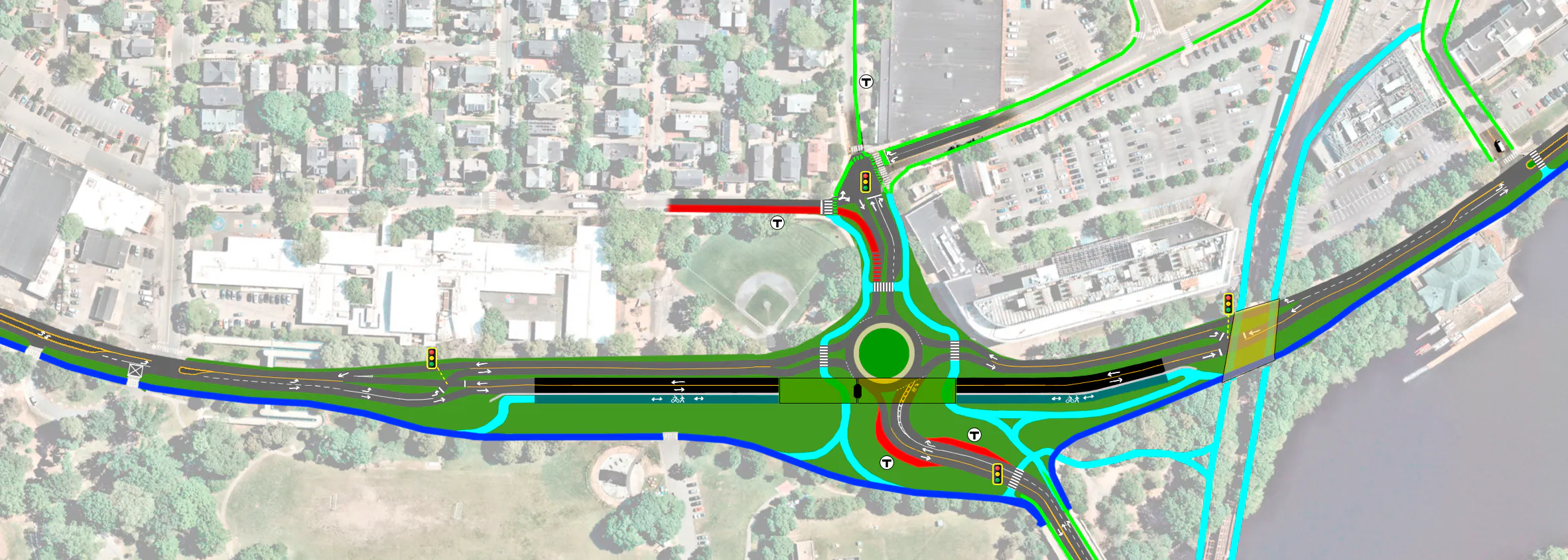
The core concept: safety first
The very core aim of the Alternative C design is to have the safest possible intersection layout, which is a compact single-lane roundabout.
Studies have repeatedly shown that properly designed roundabouts (very different from the disorganized, oversized, high-speed multi-lane rotary we have today) are significantly safer than conventional signalized intersections, with conversions from the latter to the former resulting in large reductions in crashes, particularly injury crashes. MassDOT’s own roundabouts page states:
Converting an intersection with traffic signals to a roundabout can reduce property-damage-only crashes by 48% and fatal and injury crashes by 78%.
This is a result of having far fewer potential conflict points, particularly dangerous crossing conflicts, and the tight curvature (the sketch shows a circle with 120 ft diameter, but could reduce to 90 ft if MassDOT was willing) which keeps vehicle speeds to slow and safe levels that also greatly increase the rates of yielding to pedestrians.
The rest of the design might look complicated, but really just boils down to features that make it feasible to deploy this safe single-lane roundabout design here:
- a 2-lane overpass keeps heavy Mem Drive thru traffic out of the intersection, reducing roundabout traffic volumes to manageable levels
- shifting the roundabout north of the overpass (rather than having the overpass sit centered in between the roundabout entry/exit points) allows it to remain compact and therefore retain the appropriate tight geometry that keeps vehicle speeds low
- 2 crossovers are needed on either side to facilitate this northward shift - but these are extremely simple 2-phase intersections
This layout in turn lends itself to additional beneficial features. First, because the proposal includes an overpass, a ped/bike overpass path becomes an easy add-on (whereas MassDOT would be very unlikely to spring for a standalone ped/bike bridge), allowing river path users to skip over this intersection entirely with no long waits and conflicts with cars like there are at the Western Ave, River St, and Mass Ave crossings.
Additionally, the presence of the crossovers enables roundabout metering, which makes this layout resilient and flexible for a variety of different situations (see slides 12-16 of the old AltC summary for more detail/diagrams):
- Preventing gridlock during unusual/non-routine spikes in traffic, e.g. Red Sox games at Fenway
- Purposeful balancing of local vs. regional flows, by creating gaps in upstream traffic that provide more chances for drivers exiting Cambridgeport to merge in when things start backing up into the neighborhood
- Transit priority for buses + signal preemption for emergency vehicles - as a priority vehicle approaches the intersection, the corresponding entry leg can be given a green while all other entries get a red, clearing out any queues in advance. This also clears out the roundabout exit lanes so that emergency vehicles can use the opposing lane if needed.
The metering concept itself is not that complex either. Basically, if one of the roundabout legs starts backing up, reduce the flow of cars entering the roundabout via the other 3 legs (particularly the Memorial Drive ones) until that resolves.
Some additional benefits
Roundabouts aren’t just safer, they are highly space-efficient overall. It might seem counter-intuitive, but the slow and steady traffic flow in a roundabout is more efficient than for a signalized intersection, where traffic necessarily needs to be stopped half the time to let the cross street traffic proceed. This reduction in green time is typically compensated by increasing the number of lanes at the intersection to still get the same number of cars through each cycle. This is why even though MassDOT’s TDI design has a 2-lane overpass to handle Mem Drive thru traffic, their at-grade design still has 4 lanes for that exact same thru traffic.
Roundabouts also don’t need separate dedicated lanes for every possible turning movement at an intersection, e.g. as mentioned above, MassDOT’s designs have dedicated turn lanes even for low-volume movements, including ones with just 1 car every 1-2 minutes. This is yet another reason why MassDOT’s at-grade designs all ended up so big.
The result is that with a roundabout design, crossing distances are kept short and a lot of riverfront space is reclaimed, as the comparison table numbers show.
The northward shift also extends the effective “length” of the BU Bridge, adding ~300+ ft to the short 1000 ft current length10, which provides more space for vehicles to queue in an orderly manner instead of overflowing into the intersections at either end. The added length also has curves and brings cars to a flatter area before they enter the intersection, which helps them slow down from the BU Bridge downhill speeds.
It’s really not that unusual
Roundabouts are proven safe intersection topology, common elsewhere in the world and in a few concentrated locations in the U.S. (Carmel, Indiana being a frequently-cited example). However, they are relatively uncommon in the Boston area, though we’ve got plenty of high-speed rotaries, so there seems to be a knee-jerk reaction of “that would never work here” even before doing any kind of analysis.
MassDOT does list a few examples of relatively new modern roundabouts in the other parts of the state on their informational webpage on roundabouts. But closer to Boston, there just weren’t many good examples to point to, other than one in Somerville (Powderhouse Circle) which had certain limitations because it was quick-build only.
That is, until now: the city of Boston recently completed a project to completely rebuild a 1-mile stretch of Cummins Highway, giving it a road diet from 4 to 2 lanes and reallocating that reclaimed roadway space for over 100 new trees and better facilities for pedestrians and cyclists. Peter Furth proposed the original design, as per this 2019 post I ran across after the fact. His proposal included a roundabout to deal with a tricky 5-leg intersection on the corridor.
There’s quite a few similarities:
- Cummins Highway used to be a dangerous 4-lane
speedwayroad with traffic volumes of ~18k vehicles/day, peak hour volumes of 900-1000 EB/500-600 WB) - not too far off from Mem Drive - the roundabout is compact, approximately 90-100 ft in diameter
- MBTA buses go through here
The roundabout is so new that it’s not reflected in the satellite view yet (though here is the Google Maps link to the location), but it was captured in this video someone took riding through the recently-completed project area (he approaches the roundabout around 52 seconds into the video), providing a good preview of what this could look/feel like. Notice how the cars that initially speed past have to slow down before entering the roundabout. And here is a 2nd video (sped up) showing the same effect in the opposite direction - at 2:42 a car very quickly overtakes the cyclist, but then slows down entering the roundabout and does not catch up to the cyclist again until 2:52. That’s really effective speed control in action that’s inherently part of the road design, consistent and effective 24/7 unlike signage or enforcement. Also note that some of the crossings are raised, which is the ideal and provides additional speed reductions before cars enter neighborhood streets.
Traffic feasibility
Again, it might seem unlikely that a roundabout could handle the heavy traffic here. But one of the key things is that the heaviest exit (to BU Bridge SB) is right before the heaviest entry (from BU Bridge NB), meaning there’s tons of gaps and therefore very little conflict/delay for those BU Bridge NB cars. In addition, the design as sketched has a bypass lane for the right turn movement from BU Bridge NB to Mem Drive EB, which helps during the brief peak periods where things get close to operational limits.
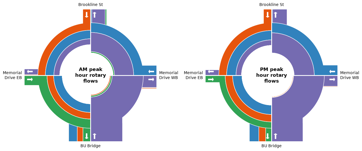
Plugging in AM and PM peak hour MV + ped + bike volumes into this roundabout analysis tool11 shows that a single-lane roundabout with a bypass lane for BU Bridge > Mem Drive EB right turns has a peak hour LOS of C, which is better than the LOS of E for either of MassDOT’s options12.
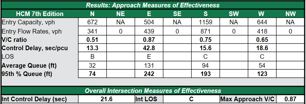
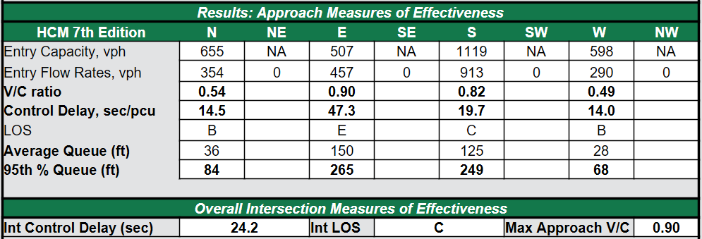
For the 4 individual roundabout legs, the worst-case LOS is B/E/C/C. Now this was just a quick check - I did not touch GDOT’s default settings (for things like peak hour factor, % heavy vehicles) - so that could have some impact on the results. But the point is that Alternative C is feasible enough to merit more detailed traffic analysis by the team.
I also plotted continuous hourly flows across the entire day (taking the sum of a rolling window of four 15-minute counts) for all 4 roundabout entries, and overlaid the data on the NCHRP guidance for the maximum capacity of a roundabout entry. The plot also shows peak hour volumes taken directly from the diagrams provided by MassDOT, in case they don’t trust my math13.
Three of the entries are comfortably below the capacity threshold. Only the southern entry from the BU Bridge gets close to the limit (grey data points), and even that is just for 1-2 hours out of the entire day. And once a bypass lane is added, that entry goes from mostly fine to definitely fine (blue data points).
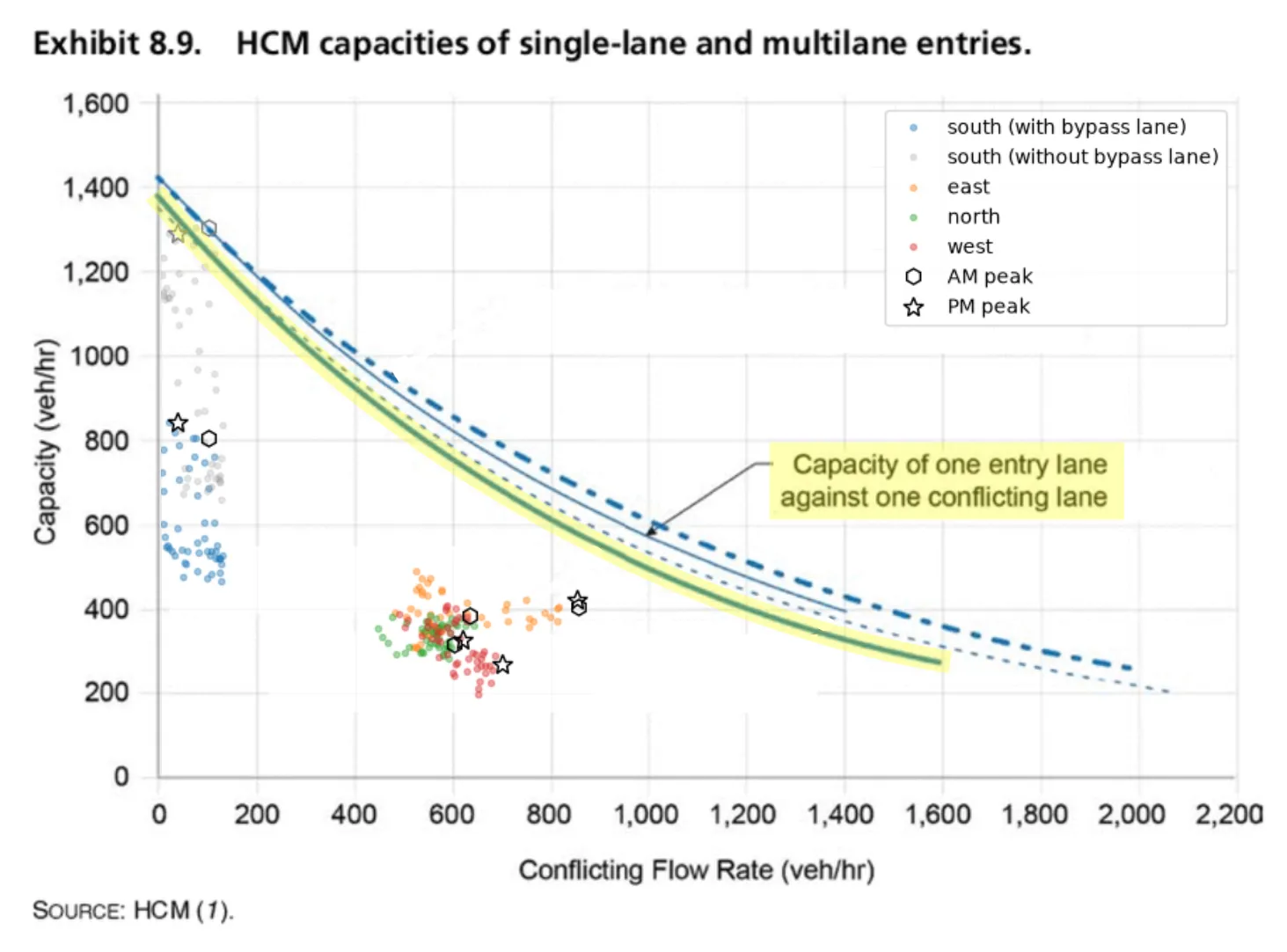
Of course, there’s also the crossover intersections to consider. But these also seem pretty feasible, because they are extremely simple 2-phase intersections. Below are the western and eastern crossovers with AM and PM peak hour volumes overlaid on the relevant segments.
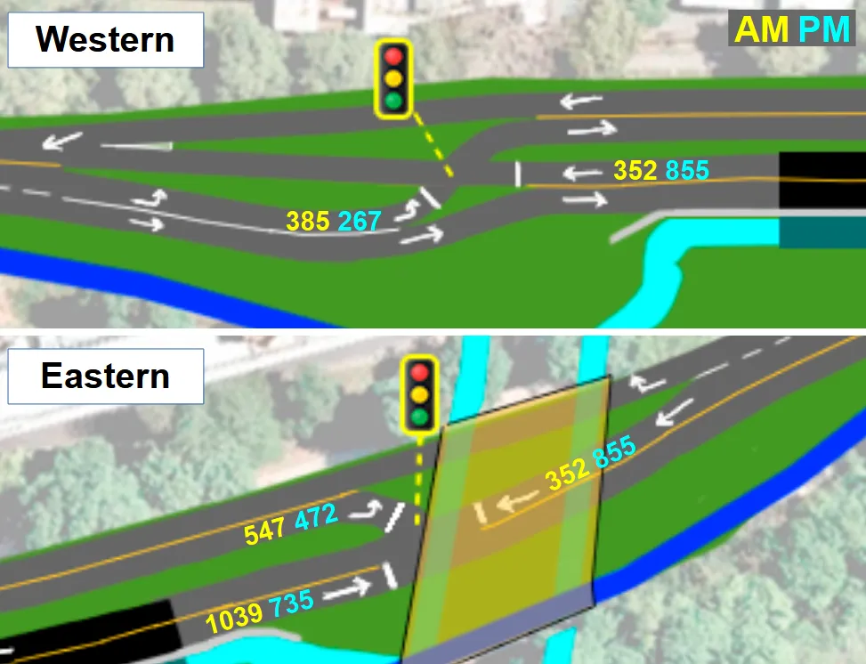
The eastern crossover is definitely the trickier one: first, it has higher volumes, with the worst case scenario being the AM peak where 1039 & 352 vph of overpass traffic conflicts with 547 vph of traffic from one of the roundabout exit legs. In addition, it’s important that the queue on that exit leg does not get too long, so that it does not overflow into the roundabout circulating lane causing it to lock up.
Once again doing some back-of-the-envelope math similar to the previous road diet discussion: if 2/3 of the crossover signal’s green time is given to overpass thru traffic & 1/3 to the roundabout outflow left turn, and using an ideal saturation flow rate value of ~1900 cars/hour/lane, that yields a capacity of 1266 & 633 vph, respectively. Which is higher than the measured peak volumes shown above (to be exact, the counts are 86% and 82% of these rough capacity numbers, respectively), so the crossovers seem feasible as well. In the worst case scenario, a queue might form on Mem Drive EB for a few minutes, but that’s hardly the end of the world. Again, traffic is not set in stone and if the queues get long enough, drivers will opt for one the many alternative routes in the area.
As mentioned above, we obviously don’t want the exit leg to back up into the roundabout. As currently drawn there is about ~400 ft between the roundabout lane and the eastern crossover, fitting maybe ~20 cars, so the red light for the exit leg at the crossover can’t be too long. The eastern roundabout outflow at its heaviest (AM peak) is 547 vph, meaning a 20-car queue would take ~131 seconds to pile up. So the signal cycle length should be shorter than that.
As for the western crossover, the worst case scenario is in the PM peak, with 265 vph eastbound towards the roundabout conflicting with 855 vph westbound coming off the overpass. This is significantly lower than the eastern crossover, so definitely feasible.
Of course there are more detailed considerations (all-red signal time, startup loss, etc.), and there will be interactions between the roundabout, the crossovers, and the neighboring intersections that can only be captured through traffic simulations. But again, I’m just trying to show there is a strong-enough case for actually trying to run that evaluation/simulation, rather than prematurely dismissing the proposal on minor grounds.
Finally, the AltC sketch includes the aforementioned road diet of Mem Drive from 4 to 3 lanes. Once again, this is not necessary for AltC to function (in case MassDOT treats this like a dealbreaker for the core proposal), but it is in keeping with the goals that drove the AltC design. It reclaims riverfront space in spots that MassDOT’s proposals neglect, particularly some of the worst river path bottlenecks, which are by the BU Boathouse and by the Magazine Beach park (again, both MassDOT designs maintain the 4-lane Mem Drive cross section on either side of the BU Bridge intersection). This also creates more of a buffer between the path and roadway so that if a car jumps the curb again, it might buy a little more time for people to react and avoid a deadly collision.
One potential concern with having a shorter 2-lane section on the intersection approach, rather than 2 lanes throughout, is that one of the lanes might back up and cut off access to the other (I believe the applicable technical terms are “queue spillback” and “demand starvation”). However, this doesn’t seem like it will be a major issue, based on the ratio of traffic headed to the overpass vs. the rotary from each direction, which shows that during the peak hours, most traffic is overpass-bound.
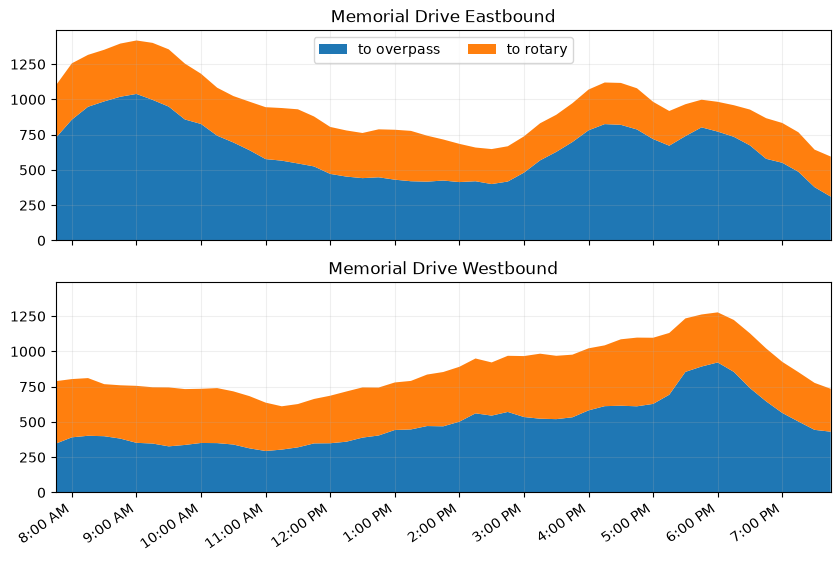
Modifications to the design
To address some of MassDOT’s comments, I have modified/simplified the proposal a bit. This is not because I think the original version was bad; rather, the goal was to make the design more palatable to MassDOT so that even if some features get left out, the most important core safety benefits can still be achieved.
- Removed the 47 bus bypass via Magazine St. I still think this would provide the most transit benefit, but MassDOT seems to consider anything touching neighborhood traffic circulation beyond the scope of this project, and does not seem eager for the kind of close collaboration with the Cambridge DOT and the MBTA this would require. So for now, I just replaced it with a queue jump on Brookline St to mirror MassDOT’s designs.
- Note: this change also means an access lane for the Magazine Beach parking lot is missing - but I left it out for now since none of the other options drew in that access either. The routing can easily be figured out later once the main intersection layout is finalized.
- Depending on how that access lane is routed, the overpass bridge span can likely be shortened as well.
- BU Bridge at-grade crossing changed back into single-stage crossing rather than split. The rationale of the split crossing was to reduce delays - both so that cars did not back up into the roundabout, and so that path users could get more frequent crossing opportunities/a faster signal cycle. However, MassDOT raised concerns about the yield-control crossing on the single exit lane. They are right that this is one of the higher-volume car movements (a car every ~4 seconds at peak) but I still think that it would be fine with an RRFB and the proper geometry to ensure slow speeds on the approach, since it’s speed more than volume that’s the problem for yielding. However, this is not a critical feature of AltC so changing it back is not an issue. The reduced crossing frequency given most river path users will take the overpass + increased distance of the crossing from the roundabout mean a single 3-lane crossing would not be as much of a problem as it is today. All I ask is that MassDOT does NOT install a HAWK signal here…
And I didn't have time to draw this yet, but there’s several options for modifying the crossovers to address MassDOT’s emergency vehicle access concerns. They did not actually specify what their concerns were (they only said they had them), so this is a bit of a stab in the dark. If they provided more detail I would be happy to come up with other solutions. But basically, the traffic islands at the crossovers can be modified (sections converted to paint + flexposts) so that there is always a way to get around onto the oncoming lane. In combination with emergency signal preemption, this would ensure unimpeded emergency access. There’s also always the brute-force option of adding wide shoulders to all the roundabout legs, though I didn’t draw this out because this is not my preferred approach (again, wide roadways encourage speeding).
Also, as mentioned above I really liked the transit components of the Ari Ofesevit’s proposal, particularly the addition of stops for the 85 bus (a key cross-town bus route, was formerly the CT2) to address a large ~0.7 mile gap between stops14 which would make this route significantly more accessible to Cambridgeport residents. This idea should be incorporated into whatever design concept proceeds to the next stage, and I’ve modified the sketch to show how this could be done for the AltC design by adding bus bays on either side of the southern/BU Bridge leg of the roundabout (stopping in the lane works too but I assumed MassDOT would have concerns about that causing delays for drivers).
A note about crossings
The south crossing (the BU Bridge leg) will be signalized and also has the overpass alternative, while the north crossing sees low usage. The main crossings of concern are the east and west crossings, serving north-south foot/bike traffic.
Both of these are yield-controlled crossings of 2 lanes with an island in the middle, so people can negotiate a single lane/direction of traffic at a time, and there is no risk of double-threat crashes (see this section from the old writeup for an explanation). The maximum traffic flow is at the east crossing, specifically the exit lane towards Mem Dr EB at 547 vehicles/hour (during the AM peak) which translates to a car every 6-7 seconds. This is still pretty manageable. Again the key is keeping vehicle speeds low to get good yield rates, which can be achieved with geometry on the approach - tight curves, narrowed roadway width, good sightlines for path users in parallel, and so on (basically, do the exact opposite of this awful slip lane crossing example). In addition, the crossing should be set back enough so that for the entry lane, a car can wait ahead of the crossing rather than blocking it, while for the exit lane, people crossing have enough time to judge whether a car is continuing to circulate vs. exiting towards their leg. RRFBs can be added to further boost pedestrian visibility.
As discussed previously, the east/S>N crossing is a major weak point of MassDOT’s designs. But in Alternative C, cars will slow down to enter the roundabout due to the geometry, but also because they need to watch out for already-circulating cars - drivers are most likely to be extra careful and attentive when there’s an element of self-preservation involved. Only after that first slowdown do they approach the ped/bike crossing, so they will be traveling at reduced speeds that make them likely to yield. Whereas in the other designs, that same crossing is approached by cars coming straight off the BU Bridge downhill at high speeds, with the only thing “stopping” them not being anything physical, but just a red light - which not everyone will obey.
Footnotes
-
At the April workshop, advocates did not press upon that point as strongly as they might have otherwise: at the start of the meeting, the project team stressed that the large intersection footprints in the workshop designs were due to them being conservative/avoiding over-promising until they completed a traffic analysis with the latest April 2026 count data. So advocates withheld judgement and focused their feedback on other aspects of the designs instead. ↩︎
-
Below is the full list of reasons why MassDOT had previously ruled out this option, text taken straight from slide 30 of their January presentation:
Critical Limitations:
- Cycling/pedestrian crossings long
- Opportunities for accessible greenspace are limited
- Introduction of Memorial Drive traffic overloads the intersection:
- Poor overall operations
- Extremely long queues which do not clear during peak hours
- Opportunities for the box blocking we observe today
- Increase fuel consumption and emissions as compared to today
- Lends itself to off-peak speeding
- Out of keeping with the community’s goal for safer, multimodal and context-sensitive design nor the city’s vision of progressive infrastructure
-
Just along Mem Drive alone, crash clusters flagged in the state’s HSIP program include:
- Memorial Drive/JFK Street (a 4x3-lane four-way at-grade intersection)
- used to be in the top 5% bicycle crash clusters in MPO
- Memorial Drive/Flagg St (a 4x2-lane three-way T intersection)
- top 5% intersection crash cluster in MPO
- Memorial Drive/River St (a 4x3-lane four-way at-grade intersection)
- top 5% intersection crash cluster in MPO
- has also been in the state-wide top 200 in past published clusters
- Memorial Drive/Western Ave (a 4x3-lane four-way at-grade intersection)
- top 200 crash cluster, state-wide
- Memorial Drive/Mass Ave (a TDI that’s simpler that MassDOT’s TDI design, and the site of a recent fatal cyclist crash)
- top 200 crash cluster, state-wide
- top 5% bicycle crash cluster in MPO
- Land Blvd/Gilmore Bridge/Route 28 (a four-way at-grade intersection that is 5-7 x 6-7 lanes, so just 1 lane bigger than MassDOT’s four-way at-grade design)
- top 200 crash cluster, state-wide
- top 5% bicycle crash cluster in MPO
- top 5% pedestrian crash cluster in MPO
And on the opposite riverbank along Soldier’s Field Road, which is also a DCR parkway like Memorial Drive, 3 consecutive intersections (Cambridge St/River St bridge, Western Ave, N. Harvard St/Anderson Memorial Bridge/JFK St) are TDI variants that all currently are or have recently been in the top 5% high-crash intersections in the Boston MPO. ↩︎
- Memorial Drive/JFK Street (a 4x3-lane four-way at-grade intersection)
-
The proposal was actually first put forward in 2023, by Furth and the BU Bridge Safety Alliance. There were some changes implemented at the Comm Ave intersection in 2025 by MassDOT & the city of Boston’s Transportation Department that appear to align with Furth’s proposal, though I am not sure how closely the exact timing recommendations were followed. But it seems safe to say that this bottleneck is now maxed-out, or at least cannot be increased further without making tradeoffs impacting Comm Ave (not just motor vehicles, but Green Line trains and crossing pedestrians as well) ↩︎
-
The speed data in this graph were collected on 3 weekdays in April 2026 (Tuesday 4/7 through Thursday 4/9). ↩︎
-
Note that this also means a LOT of storage space is needed for cars to line up during the red. ↩︎
-
Some might point to MassDOT’s McGrath Boulevard project as a precedent, but that’s not an equivalent situation to Memorial Drive. McGrath traffic had already dropped to ~50% of the historical peak, with volumes initially cratering after the completion of the Big Dig shifted a bunch of traffic to I-93, from a previous peak volume of 46k vehicles/day to 32-33k. Then volumes continued to drop from there, to ~23k in 2023. But even with data in hand showing that 50% drop, it still took a considerable advocacy push to reduce capacity to 66% (a 6 to 4 lane reduction) - not to mention MassDOT is still planning on very wide intersections. But as Storrow Drive and the Pike already exist, there is nothing that could organically produce a similar dramatic drop in Mem Drive traffic volumes. Now, if MassDOT proactively took steps to reduce VMT as per the state’s environmental goals/commitments, rather than just waiting for it to happen, it would be a different story - but we all know what the chances of that are. ↩︎
-
In the January presentation, MassDOT labeled their at-grade designs with A1, A2 etc., while designs with a rebuilt bridge/overpass were labeled with B1, B2, etc. I didn’t like any of those oversized layouts, hence a “compact” alternative C proposal. ↩︎
-
I also might have spent too long going over all the options for preventing roundabout lockups. I had assumed that MassDOT was most likely to object to AltC on the basis of traffic capacity, so I was trying to proactively address that - but guess it backfired 😅 ↩︎
-
This northward shift is also something that MassDOT’s 4-way at-grade design does, based on the at-grade advocate proposal from Peter Furth. This is the one aspect of the at-grade proposal that has improved since January. Ari Ofsevit’s Hybrid Concept also does this. ↩︎
-
This tool was developed by the GDOT (the Georgia state DOT) based on NCHRP guidelines and research reports. Traffic volume inputs were taken directly from the AM & PM peak hour flow diagrams that the project team shared (rather than calculated from the raw count data). Pedestrian and cyclist counts were combined and entered into the GDOT tool in the fields for ”# of pedestrians” crossing each leg. The counts were the worst-case scenario counts assuming no one uses the overpass ped/bike path, which is very unlikely to be the case. ↩︎
-
During MassDOT’s most recent Zoom meeting with advocates, the project team said the 4-way at-grade design has LOS E, and that the TDI design was the same or worse. ↩︎
-
The rolling hourly sums do not perfectly align with MassDOT’s peak hour flows, as they made some minor adjustments between going from raw count data to their peak flow diagrams, which I don’t have the details of to replicate. But they are pretty close. Note: there was a brief anomaly around the PM peak when calculating the circulating flow at the south leg (east leg circulating + entering flows, then subtracting flows exiting at the south leg), with 4 negative data points. My guess is this is due to sensor count error thanks to the chaotic last-minute merging that happens at this spot when things are congested. As a quick fix, these negative values were made zero before rolling hourly sums were calculated. But the effect of this is very minor and would not alter any conclusions. ↩︎
-
The MBTA’s official bus stop design guide recommends bus stop spacing of around a quarter-mile, but the 85 bus has nothing between the Vassar/Amesbury stops in Cambridge and the Mountfort/Comm Ave stops in Boston, leading to a ~0.7 mile gap surrounding the BU Bridge. So even though the 85 goes through the rotary and passes right by Cambridgeport, Cambridgeport residents need to walk ~0.4 miles (as measured from the Granite/Brookline intersection) to the nearest stop. ↩︎